
-
Federal
Global Reservoir and Dam Database, Version 1 (GRanDv1): Dams, Revision 01
National Aeronautics and Space Administration —
The Global Reservoir and Dam Database, Version 1, Revision 01 (v1.01) contains 6,862 records of reservoirs and their associated dams with a cumulative storage... -
Federal
GLDAS Noah Land Surface Model L4 monthly 0.25 x 0.25 degree V2.0 (GLDAS_NOAH025_M) at GES DISC
National Aeronautics and Space Administration —
NASA Global Land Data Assimilation System Version 2 (GLDAS-2) has three components: GLDAS-2.0, GLDAS-2.1, and GLDAS-2.2. GLDAS-2.0 is forced entirely with the... -
Federal
15 Minute Stream Flow Data: USGS (FIFE)
National Aeronautics and Space Administration —
USGS 15 minute stream flow data for Kings Creek on the Konza Prairie -
Federal
GLDAS Catchment Land Surface Model L4 daily 0.25 x 0.25 degree V2.0 (GLDAS_CLSM025_D) at GES DISC
National Aeronautics and Space Administration —
NASA Global Land Data Assimilation System Version 2 (GLDAS-2) has three components: GLDAS-2.0, GLDAS-2.1, and GLDAS-2.2. GLDAS-2.0 is forced entirely with the... -
Federal
RADARSAT-1_LEVEL1
National Aeronautics and Space Administration —
RADARSAT-1 Level 1 Amplitude Images -
Federal
CLPX-Model: Land Data Assimilation System (LDAS) Data, Version 1
National Aeronautics and Space Administration —
The LDAS data set contains 43 model and observation-based fields produced by the LDAS uncoupled modeling system at the NASA Goddard Space Flight Center using the... -
Federal
CLPX-Model: Rapid Update Cycle 40km (RUC-40) Model Output Reduced Data, Version 1
National Aeronautics and Space Administration —
The Rapid Update Cycle, version 2 at 40km (RUC-2, known to the Cold Land Processes community as RUC40) model is a Mesoscale Analysis and Prediction System (MAPS) data... -
Federal
GLDAS VIC Land Surface Model L4 monthly 1.0 x 1.0 degree Early Product V2.1 (GLDAS_VIC10_M_EP) at GES DISC
National Aeronautics and Space Administration —
NASA Global Land Data Assimilation System Version 2 (GLDAS-2) has three components: GLDAS-2.0, GLDAS-2.1, and GLDAS-2.2. GLDAS-2.0 is forced entirely with the... -
Federal
GLDAS Noah Land Surface Model L4 monthly 0.25 x 0.25 degree V2.1 (GLDAS_NOAH025_M) at GES DISC
National Aeronautics and Space Administration —
NASA Global Land Data Assimilation System Version 2 (GLDAS-2) has three components: GLDAS-2.0, GLDAS-2.1, and GLDAS-2.2. GLDAS-2.0 is forced entirely with the... -
Federal
SWOT Level 2 Lake Single-Pass Vector Data Product, Version 2.0
National Aeronautics and Space Administration —
The SWOT Level 2 Lake Single-Pass Vector Data Product from the Surface Water Ocean Topography (SWOT) mission provides water surface elevation, area, storage change... -
County
Lake County Wetland Inventory
Lake County, Illinois —
Download In State Plane Projection Here The Lake County Wetland Inventory (LCWI) maps natural and artificial wetlands meeting definitions established by the federal... -
Federal
Monthly Historical Water Balance Products for the CONUS
National Aeronautics and Space Administration —
This dataset provides daily historical Water Balance Model outputs from a Thornthwaite-type, single bucket model. Climate inputs to the model are from GridMet daily... -
Federal
Merged Sentinel-3A and Sentinel-3B OLCI Global Binned Cyanobacteria Index (CI) Data, version 5.0
National Aeronautics and Space Administration —
Cyanobacteria Assessment Network (CyAN) is a multi-agency project among EPA, the National Aeronautics and Space Administration (NASA), the National Oceanic and... -
Federal
Sea Ice in the Belcher Islands, Nunavut, Canada, Version 1
National Aeronautics and Space Administration —
This data set contains interviews of three hunters from Sanikiliaq, Belcher Islands, in the territory of Nunavut, Canada. The hunters describe their observations of... -
Federal
FLDAS Noah Land Surface Model L4 Global Monthly 0.1 x 0.1 degree (MERRA-2 and CHIRPS) V001 (FLDAS_NOAH01_C_GL_M) at GES DISC
National Aeronautics and Space Administration —
This dataset contains a series of land surface parameters simulated from the Noah 3.6.1 model in the Famine Early Warning Systems Network (FEWS NET) Land Data... -
Federal
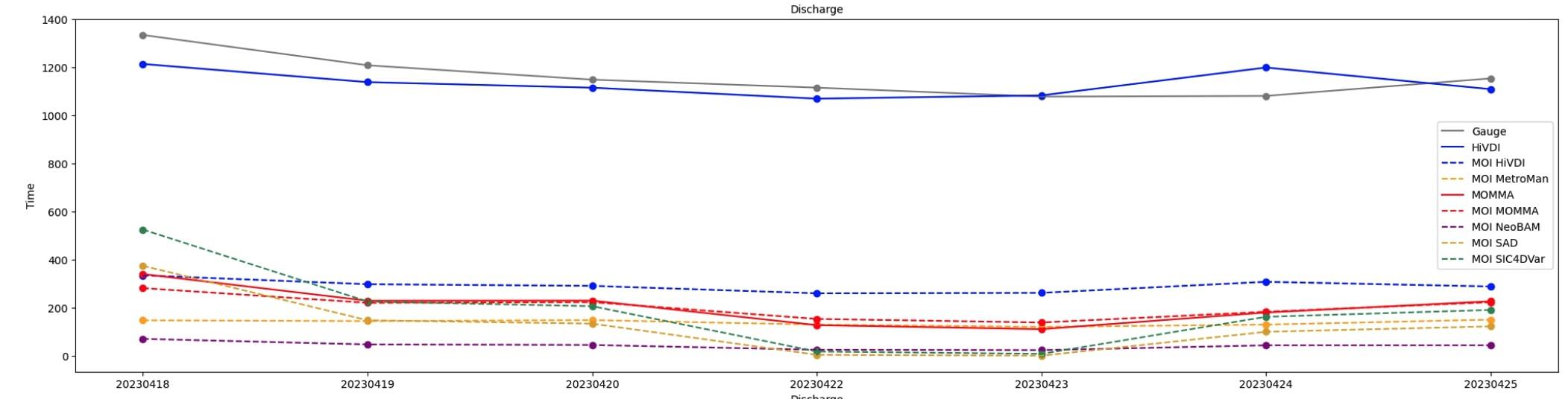
SWOT Sword of Science River Discharge Products Version 1
National Aeronautics and Space Administration —
This dataset contains estimates of river discharge generated from hydrology observations taken by the Surface Water and Ocean Topography (SWOT) satellite. Data... -
Federal
GLDAS Catchment Land Surface Model L4 daily 0.25 x 0.25 degree GRACE-DA1 V2.2 (GLDAS_CLSM025_DA1_D) at GES DISC
National Aeronautics and Space Administration —
NASA Global Land Data Assimilation System Version 2 (GLDAS-2) has three components: GLDAS-2.0, GLDAS-2.1, and GLDAS-2.2. GLDAS-2.0 is forced entirely with the... -
Federal
USGS Digital Orthophoto Quadrangles
National Aeronautics and Space Administration —
A Digital Orthophoto Quadrangle (DOQ) is a computer-generated image of an aerial photograph in which the image displacement caused by terrain relief and camera tilt... -
Federal
LBA-ECO CD-06 Amazon River Basin Land and Stream Drainage Direction Maps
National Aeronautics and Space Administration —
This data set provides high-resolution (~500 m) gridded land and stream drainage direction maps for the Amazon River basin, excluding the Rio Tocantins basin. These... -
Federal
GLDAS CLM Land Surface Model L4 3 hourly 1.0 x 1.0 degree Subsetted V001 (GLDAS_CLM10SUBP_3H) at GES DISC
National Aeronautics and Space Administration —
With the upgraded Land Surface Models (LSMs) and updated forcing data sets, the GLDAS version 2.1 (GLDAS-2.1) production stream serves as a replacement for GLDAS-001....

Official websites use .gov
A
.gov website belongs to an official government
organization in the United States.
Secure .gov websites use HTTPS
A
lock (
) or https:// means you’ve safely connected to
the .gov website. Share sensitive information only on official,
secure websites.