

55 datasets found
-
Federal
Crop response and changes in soil properties as affected by soil erosion, topsoil replacement, and application of anaerobically digested dairy manure solids in a Mollisol landform
Department of Agriculture —
These data provide field measurements of plant and soil at a geographical site as affected by (a) tillage and water erosion (b) replacement of translocated topsoil... -
Federal
Fire Island National Seashore bathymetry survey, 2024
Department of the Interior —
Multibeam sonar data collected with an EchoBoat 160 (Seafloor Systems, Inc.) autonomous surface vessel (ASV) equipped with an iWBMSe multibeam sonar (NORBIT). Data... -
Federal
Charles M. Russell National Wildlife Refuge Fire History GIS Feature Classes
Department of the Interior —
Summary This feature class documents the fire history on CMR from 1964 - present. This is 1 of 2 feature classes, a polygon and a point. This data has a variety of... -
Federal
Tuxedni Channel bathymetric survey 2024-2025, Lake Clark National Park and Preserve
Department of the Interior —
Multibeam sonar data collected with an EchoBoat 160 (Seafloor Systems, Inc.) autonomous surface vessel (ASV) equipped with an iWBMSe multibeam sonar (NORBIT). Data... -
Federal
Ocean Currents (U, V, W) and temperature time-series measurements collected from two ADCP ocean moorings (5-month summer and 8-month winter) at long-term Mooring Site M2 on the southeastern Bering Sea shelf, Alaska, by the EcoFOCI group at NOAA, PMEL, 2018-05-02 to 2019-04-24 (NCEI Accession 0311368)
National Oceanic and Atmospheric Administration, Department of Commerce —
M2 - These time-series sets consist of data from two Acoustic Doppler Current Profiler (ADCP) moorings at the long-term mooring site "M2" on the southeastern Bering... -
Federal
Cape Cod National Seashore bathymetry survey, September 2023
Department of the Interior —
Multibeam sonar data collected with an EchoBoat 160 (Seafloor Systems, Inc.) autonomous surface vessel (ASV) equipped with an iWBMSe multibeam sonar (Norbit). Data... -
Federal
Data from: Spatial and temporal features of snow water equivalent across a headwater catchment in the Sierra Nevada
Department of Agriculture —
Accompanying dataset for: “Spatial and Temporal Features of Snow Water Equivalent Across a Headwater Catchment in the Sierra Nevada”Abstract:Here, we present the... -
Federal
Data and Code: Increasing global risk of khapra beetle invasion forecasted under diverse environmental conditions
Department of Agriculture —
The khapra beetle, Trogoderma granarium, is a stored product pest of global concern. The pest is readily transported with cargo and has been reported in over 60... -
Federal
UARS Cryogenic Limb Array Etalon Spectrometer (CLAES) Level 3AL V009 (UARCL3AL) at GES DISC
National Aeronautics and Space Administration —
The Cryogenic Limb Array Etalon Spectrometer (CLAES) Level 3AL data product consists of daily, 4 degree increment latitude-ordered vertical profiles of temperature... -
Federal
2010 NOAA/USGS Lidar: French Frigate Shoals, NWHI
National Oceanic and Atmospheric Administration, Department of Commerce —
The U.S. Geological Survey (USGS) contracted with Hawaii-based Aerial Surveying, Inc. to collect lidar-derived elevation data over the low-lying areas within the... -
Federal
Sagebrush Steppe Ecological Resilience and Invasion Resistance Geodatabase for Parashant National Monument
Department of the Interior —
Geospatial database of soils, vegetation, and related information that supports mapping and assessment of potential ecological resilience to fire and resistance to... -
Federal
<b>Soil, crop, and weed communities as affected by soil erosion and topsoil replacement in a Mollisol landform (a six-year soil-landscape rehabilitation study)</b>
Department of Agriculture —
These data provide field measurements at two geographical sites of plant and soil as affected by (a) tillage and water erosion and (b) replacement of translocated... -
Federal
UARS Correlative UKMO Daily Gridded Stratospheric Assimilated Data V001 (UARZCUKM) at GES DISC
National Aeronautics and Space Administration —
The UARS Correlative assimilation data from the U.K. Meteorological Office (UKMO) consists of daily model runs at 12:00 GMT as a means of providing an independent... -
Federal
Sagebrush Steppe Ecological Resilience and Invasion Resistance Geodatabase for Big Hole National Battlefield
Department of the Interior —
Geospatial database of soils, vegetation, and related information that supports mapping and assessment of potential ecological resilience to fire and resistance to... -
Federal
Water Monitoring Data - Geospatial Data - Cumulative Watersheds
Department of the Interior —
GIS shapefiles of cumulative watersheds models based on NETN's long-term water quality monitoring stations. Holdings include step-by-step instructions on how they... -
Federal
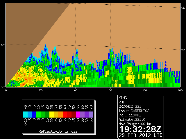
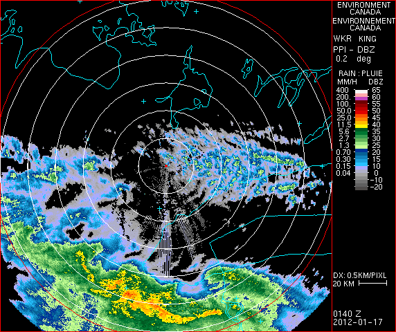
GPM GROUND VALIDATION DUAL POLARIZED C-BAND DOPPLER RADAR KING CITY GCPEX V1
National Aeronautics and Space Administration —
The GPM Ground Validation Dual Polarized C-Band Doppler Radar King City GCPEx dataset has special Range Height Indicator (RHI) and sector scans of several dual... -
Federal
UARS High Resolution Doppler Imager (HRDI) Level 3AL V011 (UARHR3AL) at GES DISC
National Aeronautics and Space Administration —
The High Resolution Doppler Imager (HRDI) Level 3AL data product consists of daily, 4 degree increment latitude-ordered vertical profiles of meridional and zonal wind... -
Federal
Sagebrush Steppe Ecological Resilience and Invasion Resistance Geodatabase for the Hagerman Fossil Beds National Monument
Department of the Interior —
Geospatial database of soils, vegetation, and related information that supports mapping and assessment of potential ecological resilience to fire and resistance to...
55 datasets found