
-
Federal
TRMM Precipitation Radar Rainfall Rate and Profile L2 1.5 hours V7 (TRMM_2A25) at GES DISC
National Aeronautics and Space Administration —
The new version of these data is in GPM-like format (consistent with the GPM Dual-frequency Radar data format), and can be found under the name GPM_2APR. The TRMM... -
Federal
SatCORPS CERES GEO Edition 4 GOES-15 Southern Hemisphere Version 1.0
National Aeronautics and Space Administration —
CER_GEO_Ed4_GOE15_SH_V01 is the Satellite Cloud and Radiation Property retrieval System (SatCORPS) Clouds and the Earth's Radiant Energy System (CERES) Geostationary... -
Federal
NOAA/WDS Paleoclimatology - Yao fire data from Mengkeshan, Daxing'an Mountain, Heilongjiang, China - IMPD CNMKS001
National Oceanic and Atmospheric Administration, Department of Commerce —
This archived Paleoclimatology Study is available from the NOAA National Centers for Environmental Information (NCEI), under the World Data Service (WDS) for... -
Federal
ADVANCED MICROWAVE SOUNDING UNIT-A (AMSU-A) SWATH FROM NOAA-16 V1
National Aeronautics and Space Administration —
AMSU-A, the Advanced Microwave Sounding Unit, is a 15-channel passive microwave radiometer used to profile atmospheric temperature and moisture from the earth's... -
Federal
GPM GROUND VALIDATION DUAL-FREQUENCY DUAL-POLARIZED DOPPLER RADAR (D3R) GCPEX V1
National Aeronautics and Space Administration —
The GPM Ground Validation Dual-frequency Dual-polarized Doppler Radar (D3R) GCPEx and IFloodS data sets contain radar reflectivity and doppler velocity measurements.... -
Federal
TRMM Precipitation Radar Rain Characteristics L2 1.5 hours V7 (TRMM_2A23) at GES DISC
National Aeronautics and Space Administration —
The new version of these data is in GPM-like format (consistent with the GPM Dual-frequency Radar data format), and can be found under the name GPM_2APR. The TRMM... -
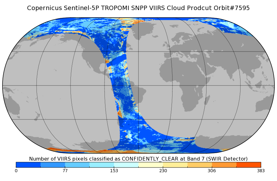
Federal
Sentinel-5P TROPOMI SNPP cloud product band 7 (SWIR detector) 1-Orbit L2 7km x 7km V1 (S5P_L2__NP_BD7) at GES DISC
National Aeronautics and Space Administration —
Starting from August 6th in 2019, Sentinel-5P TROPOMI along-track high spatial resolution (~5.5km at nadir) has been implemented. For data after August 6th of 2019,... -
Federal
JPSS-2 CrIS IMG_COL: Array indices for collocated VIIRS observations V3.0 (SNDRJ2CrISL1BIMGC) at GES DISC
National Aeronautics and Space Administration —
The Cross-track Infrared Sounder (CrIS) Level 1B Full Spectral Resolution (FSR) data files contain radiance measurements along with ancillary spacecraft, instrument,... -
Federal
TOVS GLA 5 DAY GRIDS from NOAA-11 V01 (TOVSA5NH) at GES DISC
National Aeronautics and Space Administration —
This dataset (TOVSA5NH) contains the TIROS Operational Vertical Sounder (TOVS) level 3 geophysical parameters derived using data from NOAA-11 and the physical... -
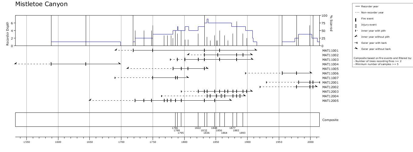
Federal
NOAA/WDS Paleoclimatology - Azpeleta Tarancón fire data from Mistletoe Canyon, south central New Mexico - IMPD USMC-001
National Oceanic and Atmospheric Administration, Department of Commerce —
This archived Paleoclimatology Study is available from the NOAA National Centers for Environmental Information (NCEI), under the World Data Service (WDS) for... -
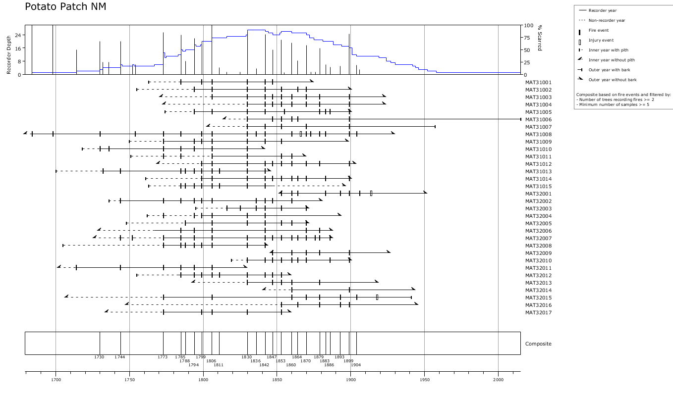
Federal
NOAA/WDS Paleoclimatology - Azpeleta Tarancón fire data from Potato Patch NM, south central New Mexico - IMPD USPP-002
National Oceanic and Atmospheric Administration, Department of Commerce —
This archived Paleoclimatology Study is available from the NOAA National Centers for Environmental Information (NCEI), under the World Data Service (WDS) for... -
Federal
NOAA/WDS Paleoclimatology - Sherriff fire data from Hells Hole West - IMPD USHHW001
National Oceanic and Atmospheric Administration, Department of Commerce —
This archived Paleoclimatology Study is available from the NOAA National Centers for Environmental Information (NCEI), under the World Data Service (WDS) for... -
Federal
NOAA/WDS Paleoclimatology - Everett fire data from Twenty Mile Aspect Polygon 12 - IMPD USTWM012
National Oceanic and Atmospheric Administration, Department of Commerce —
This archived Paleoclimatology Study is available from the NOAA National Centers for Environmental Information (NCEI), under the World Data Service (WDS) for... -
Federal
NOAA/WDS Paleoclimatology - Everett fire data from Quartzite Aspect Polygon 5 - IMPD USQZT005
National Oceanic and Atmospheric Administration, Department of Commerce —
This archived Paleoclimatology Study is available from the NOAA National Centers for Environmental Information (NCEI), under the World Data Service (WDS) for... -
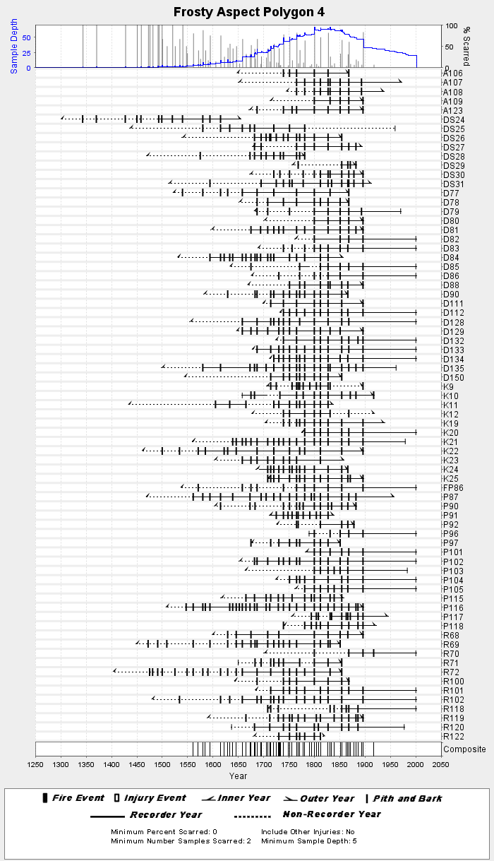
Federal
NOAA/WDS Paleoclimatology - Everett fire data from Frosty Aspect Polygon 4 - IMPD USFRS004
National Oceanic and Atmospheric Administration, Department of Commerce —
This archived Paleoclimatology Study is available from the NOAA National Centers for Environmental Information (NCEI), under the World Data Service (WDS) for... -
Federal
NOAA/WDS Paleoclimatology - Fulé fire data from Rainbow Plateau - IMPD USRP_001
National Oceanic and Atmospheric Administration, Department of Commerce —
This archived Paleoclimatology Study is available from the NOAA National Centers for Environmental Information (NCEI), under the World Data Service (WDS) for... -
Federal
NOAA/WDS Paleoclimatology - Veblen fire data from East Rio Limay - IMPD ARELI001
National Oceanic and Atmospheric Administration, Department of Commerce —
This archived Paleoclimatology Study is available from the NOAA National Centers for Environmental Information (NCEI), under the World Data Service (WDS) for... -
Federal
NOAA/WDS Paleoclimatology - Bakker fire data from Kellett Bluff, Northwest Washington - IMPD USWKB001
National Oceanic and Atmospheric Administration, Department of Commerce —
This archived Paleoclimatology Study is available from the NOAA National Centers for Environmental Information (NCEI), under the World Data Service (WDS) for... -
Federal
FLASHFlux Daily Gridded TOA and Surfaces/Clouds data Version 4C
National Aeronautics and Space Administration —
FLASH_TISA_Terra-NOAA20_Version4C is the Fast Longwave And SHortwave Fluxes (FLASHFlux) Daily Gridded Top-of-Atmosphere (TOA) and Surfaces/Clouds Version 4C data... -
Federal
ADVANCED MICROWAVE SOUNDING UNIT-A (AMSU-A) SWATH FROM NOAA-15 V1
National Aeronautics and Space Administration —
AMSU-A, the Advanced Microwave Sounding Unit, is a 15-channel passive microwave radiometer used to profile atmospheric temperature and moisture from the earth's...

Official websites use .gov
A
.gov website belongs to an official government
organization in the United States.
Secure .gov websites use HTTPS
A
lock (
) or https:// means you’ve safely connected to
the .gov website. Share sensitive information only on official,
secure websites.