
-
Federal
LIMS/Nimbus-7 Level 1 Radiance Data V001 (LIMSN7L1PROFILER) at GES DISC
National Aeronautics and Space Administration —
LIMSN7L1PROFILER is the Nimbus-7 Limb Infrared Monitor of the Stratosphere (LIMS) Level-1 Profiles of Radiance Data product and contains selected daily vertical... -
Federal
High Resolution Empirical Tide Prediction Software Version 14
National Aeronautics and Space Administration —
This dataset provides sea surface height and ocean surface currents associated with the predictable astronomical tide at the M2, S2, N2, K1, and O1 frequencies. The... -
Federal
Sentinel-1 Interferograms (BETA)
National Aeronautics and Space Administration —
Sentinel-1 SLC interferometric products generated by JPL using ISCE v2.0.0, delivered by ASF -
Federal
Sounder SIPS: AQUA AIRS IR MW Level 3 CLIMCAPS : Specific Quality Control Gridded Daily V2 at GES DISC
National Aeronautics and Space Administration —
WARNING: Users of the derived product “co_mmr_midtrop” (carbon monoxide mass mixing ratio to dry air [kg/kg] at ~500 hPa). This variable has a significant bias due to... -
Federal
JPSS-2 CrIS Level 1B Beta Full Spectral Resolution V3 (SNDRJ2CrISL1B) at GES DISC
National Aeronautics and Space Administration —
The goal of creating this product is to allow users to begin working with data from the CrIS instrument on-board the recently launched NOAA-21 / JPSS-2 (J2)... -
Federal
GOES-R PLT Lightning Instrument Package (LIP) V1
National Aeronautics and Space Administration —
The GOES-R PLT Lightning Instrument Package (LIP) dataset consists of electrical field measurements of lightning and navigation data collected by the Lightning... -
Federal
Sentinel-5P TROPOMI Methane CH4 1-Orbit L2 7km x 7km V1 (S5P_L2__CH4___) at GES DISC
National Aeronautics and Space Administration —
Starting from August 6th in 2019, Sentinel-5P TROPOMI along-track high spatial resolution (~5.5km at nadir) has been implemented. For data after August 6th of 2019,... -
Federal
GPM GROUND VALIDATION DUAL-FREQUENCY DUAL-POLARIZED DOPPLER RADAR (D3R) GCPEX V1
National Aeronautics and Space Administration —
The GPM Ground Validation Dual-frequency Dual-polarized Doppler Radar (D3R) GCPEx and IFloodS data sets contain radar reflectivity and doppler velocity measurements.... -
Federal
BUV/Nimbus-4 Level 2 High-Density Ozone Data V005 (BUVN4L2HDBUV) at GES DISC
National Aeronautics and Space Administration —
The Nimbus-4 BUV Level 2 High-Density Ozone Data collection contains the vertical distribtuion and total column amount of ozone, as well as the full set of ancillary... -
Federal
SatCORPS CERES GEO Edition 4 Meteosat-8 Northern Hemisphere Version 1.0
National Aeronautics and Space Administration —
CER_GEO_Ed4_MET08_NH_V01 is the Satellite Cloud and Radiation Property retrieval System (SatCORPS) Clouds and the Earth's Radiant Energy System (CERES) Geostationary... -
Federal
Sentinel-1 Interferograms - Amplitude (BETA)
National Aeronautics and Space Administration —
Sentinel-1 SLC interferometric products generated by JPL using ISCE v2.0.0, delivered by ASF -
Federal
TRMM Microwave Imager Hydrometeor Profile L2 1.5 hours V7 (TRMM_2A12) at GES DISC
National Aeronautics and Space Administration —
The new version of these data is in GPM-like format and can be found under the name GPM_2AGPROFTRMMTMI_CLIM. This dataset, 2A12, ”TMI Profiling”, generates surface... -
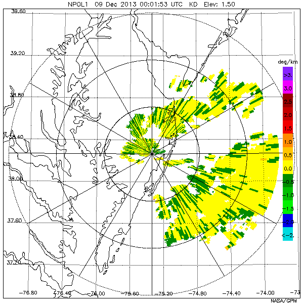
Federal
GPM Ground Validation NASA S-Band Dual Polarimetric (NPOL) Doppler Radar Wallops Flight Facility (WFF) V1
National Aeronautics and Space Administration —
The GPM Ground Validation NASA S-Band Dual-Polarimetric (NPOL) Doppler Radar Wallops Flight Facility (WFF) dataset consists of rain rate, reflectivity, Doppler... -
Federal
NOAA/WDS Paleoclimatology - Everett fire data from Quartzite Aspect Polygon 5 - IMPD USQZT005
National Oceanic and Atmospheric Administration, Department of Commerce —
This archived Paleoclimatology Study is available from the NOAA National Centers for Environmental Information (NCEI), under the World Data Service (WDS) for... -
Federal
NOAA/WDS Paleoclimatology - Everett fire data from Twenty Mile Aspect Polygon 12 - IMPD USTWM012
National Oceanic and Atmospheric Administration, Department of Commerce —
This archived Paleoclimatology Study is available from the NOAA National Centers for Environmental Information (NCEI), under the World Data Service (WDS) for... -
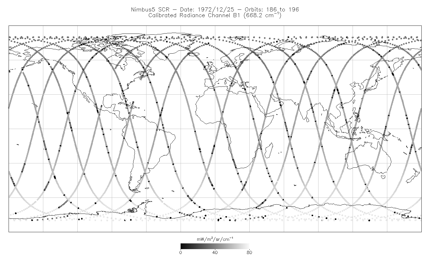
Federal
SCR/Nimbus-5 Level 1 Calibrated Radiances V001 (SCRN5L1RAD) at GES DISC
National Aeronautics and Space Administration —
SCRN5L1RAD is the Nimbus-5 Selective Chopper Radiometer (SCR) Level 1 Calibrated Radiances data product. The calibrated radiances are measured at 16 channels from 2.3... -
Federal
Sentinel-5P TROPOMI Near-Real-Time (NRT) Sulphur Dioxide SO2 1-Orbit L2 5.5km x 3.5km V2 (S5P_L2__SO2____HiR_NRT) at GES DISC
National Aeronautics and Space Administration —
The Sentinel-5P TROPOMI Near Real Time (NRT) Sulphur Dioxide SO2 1-Orbit L2 5.5km x 3.5km V2 (S5P_L2__SO2_HiRNRT) at GES DISC is the near real time version of the... -
Federal
Sounder SIPS: AQUA AIRS IR + MW Level 3 CLIMCAPS : Comprehensive Quality Control Gridded Daily V2 at GES DISC
National Aeronautics and Space Administration —
WARNING: To users of the derived product “co_mmr_midtrop” (carbon monoxide mass mixing ratio to dry air [kg/kg] at ~500 hPa). This variable has a significant bias due... -
Federal
New York State Mesonet IMPACTS V1
National Aeronautics and Space Administration —
The New York State Mesonet IMPACTS dataset is a browse-only dataset and consists of temperature, wind, wind direction, mean sea level pressure, precipitation, and...

Official websites use .gov
A
.gov website belongs to an official government
organization in the United States.
Secure .gov websites use HTTPS
A
lock (
) or https:// means you’ve safely connected to
the .gov website. Share sensitive information only on official,
secure websites.