
-
Federal
OCO-2 Level 2 geolocated XCO2 retrievals results, physical model V11.2 (OCO2_L2_Standard) at GES DISC
National Aeronautics and Space Administration —
Version 11.2 is the current version of the data set. Older versions will no longer be available and are superseded by Version 11.2. The Orbiting Carbon Observatory is... -
Federal
UARS Improved Stratospheric and Mesospheric Sounder (ISAMS) Level 3AL V010 (UARIS3AL) at GES DISC
National Aeronautics and Space Administration —
The Improved Stratospheric and Mesospheric Sounder (ISAMS) Level 3AL data product consists of daily, 4 degree increment latitude-ordered vertical profiles of... -
Federal
Sentinel-1 Interferograms - Coherence (BETA)
National Aeronautics and Space Administration —
Sentinel-1 SLC interferometric products generated by JPL using ISCE v2.0.0, delivered by ASF -
Federal
Sentinel-5P TROPOMI Tropospheric NO2 1-Orbit L2 7km x 3.5km V1 (S5P_L2__NO2___) at GES DISC
National Aeronautics and Space Administration —
Starting from August 6th in 2019, Sentinel-5P TROPOMI along-track high spatial resolution (~5.5km at nadir) has been implemented. For data after August 6th of 2019,... -
Federal
UARS Cryogenic Limb Array Etalon Spectrometer (CLAES) Level 3AL V009 (UARCL3AL) at GES DISC
National Aeronautics and Space Administration —
The Cryogenic Limb Array Etalon Spectrometer (CLAES) Level 3AL data product consists of daily, 4 degree increment latitude-ordered vertical profiles of temperature... -
Federal
Sentinel-1 Interferograms (BETA)
National Aeronautics and Space Administration —
Sentinel-1 SLC interferometric products generated by JPL using ISCE v2.0.0, delivered by ASF -
Federal
High Resolution Empirical Tide Prediction Software Version 14
National Aeronautics and Space Administration —
This dataset provides sea surface height and ocean surface currents associated with the predictable astronomical tide at the M2, S2, N2, K1, and O1 frequencies. The... -
Federal
TROPICS06 L2A Unified Resolution Brightness Temperatures V1.0
National Aeronautics and Space Administration —
The "Time-Resolved Observations of Precipitation structure and storm Intensity with a Constellation of Smallsats" (TROPICS) mission has a goal of providing nearly... -
Federal
OPERA Dynamic Surface Water Extent from Harmonized Landsat Sentinel-2 provisional product (Version 1)
National Aeronautics and Space Administration —
This dataset contains Level-3 Dynamic OPERA provisional surface water extent product version 1. The data are provisional surface water extent observations beginning... -
Federal
TRMM Precipitation Radar Rain Characteristics L2 1.5 hours V7 (TRMM_2A23) at GES DISC
National Aeronautics and Space Administration —
The new version of these data is in GPM-like format (consistent with the GPM Dual-frequency Radar data format), and can be found under the name GPM_2APR. The TRMM... -
Federal
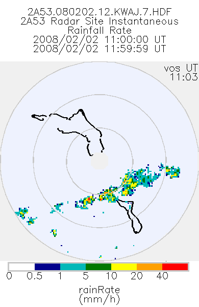
TRMM Ground Validation Radar Site Rain Rate Map L2 1 hour 2 km V7 (TRMM_2A53UW) at GES DISC
National Aeronautics and Space Administration —
This dataset is part of the University of Washington TRMM Ground Validation products. Instantaneous rain rate cartesian grid based on baseUW and 2A54UW. Units are... -
Federal
Landsat Level-2 Surface Reflectance Collection 2
National Aeronautics and Space Administration —
Landsat Level-2 Surface Reflectance Collection 2 products contain atmospherically corrected spectral reflectance data derived from Level-1 products and are available... -
Federal
TROPICS03 L2A Unified Resolution Brightness Temperatures V1.0
National Aeronautics and Space Administration —
The "Time-Resolved Observations of Precipitation structure and storm Intensity with a Constellation of Smallsats" (TROPICS) mission has a goal of providing nearly... -
Federal
TRMM Microwave Imager Precipitation Profile L3 1 month 0.5 degree x 0.5 degree V7 (TRMM_3A12) at GES DISC
National Aeronautics and Space Administration —
The new equivalent for this dataset should be searched for as "GPM_3GPROFTRMMTMI_CLIM". This product contains global monthly means of surface precipitation rate, rain... -
Federal
Legates Surface and Ship Observations of Precipitation Climatology 0.5 x 0.5 degree V1 (RAIN_LEGATES) at GES DISC
National Aeronautics and Space Administration —
The Legates Surface and Shipboard Rain Gauge Observations data set consists of a global climatology of monthly mean precipitation values. A global climatology of mean... -
Federal
TROPICS05 L1B Orbital Geolocated Native-Resolution Brightness Temperatures V0.2
National Aeronautics and Space Administration —
The "Time-Resolved Observations of Precipitation structure and storm Intensity with a Constellation of Smallsats" (TROPICS) mission has a goal of providing nearly... -
Federal
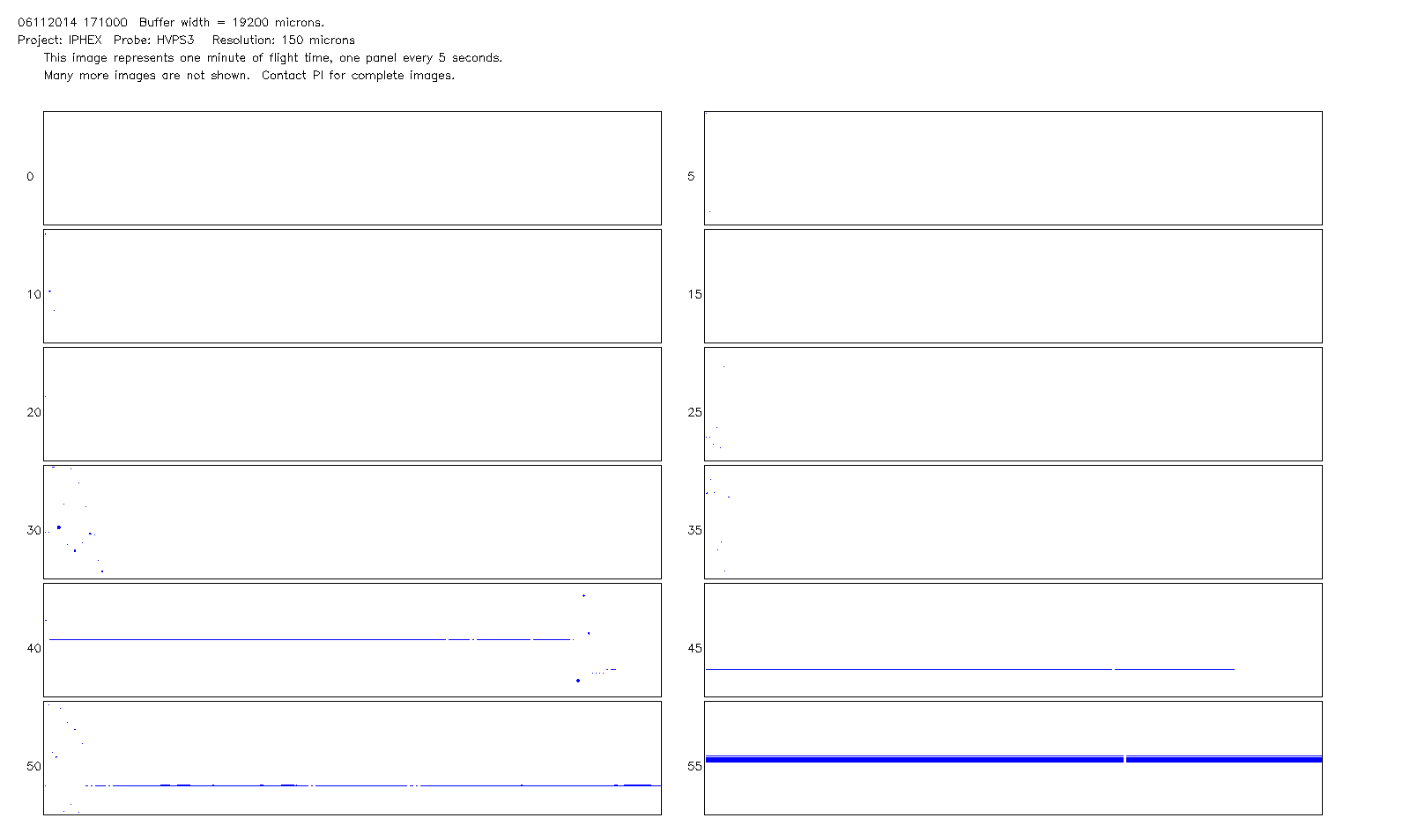
GPM Ground Validation NCAR Particle Probes IPHEx V1
National Aeronautics and Space Administration —
The GPM Ground Validation NCAR Particle Probes IPHEx dataset consists of Ice Water Content (IWC), particle number concentration normalized by bin width, and total... -
Federal
Sentinel-5P TROPOMI Methane CH4 1-Orbit L2 7km x 7km V1 (S5P_L2__CH4___) at GES DISC
National Aeronautics and Space Administration —
Starting from August 6th in 2019, Sentinel-5P TROPOMI along-track high spatial resolution (~5.5km at nadir) has been implemented. For data after August 6th of 2019,... -
Federal
THIR/Nimbus-7 Images of Daytime and Nighttime Brightness Temperature on 70 mm Film V001 (THIRN7IM) at GES DISC
National Aeronautics and Space Administration —
THIRN7IM is the Nimbus-7 Temperature-Humidity Infrared Radiometer (THIR) data product consisting of daily montages of brightness temperatures measured at 6.7 and 11.5... -
Federal
TROPESS Chemical Reanalysis Ozone 6-Hourly 3-dimensional Product V1 (TRPSCRO36H3D) at GES DISC
National Aeronautics and Space Administration —
The TROPESS Chemical Reanalysis O3 6-Hourly 3-dimensional Product contains vertical concentrations of ozone. The data are part of the Tropospheric Chemical Reanalysis...

Official websites use .gov
A
.gov website belongs to an official government
organization in the United States.
Secure .gov websites use HTTPS
A
lock (
) or https:// means you’ve safely connected to
the .gov website. Share sensitive information only on official,
secure websites.