
-
University
2012 Whitewater Baldy Post Fire, Negrito Mountain NE SW, RGB
Earth Data Analysis Center, University of New Mexico —
This dataset contains imagery for the Gila National Forest, Catron and Grant County, New Mexico. The imagery was flown to provide coverage after the 2012 Whitewater-... -
Federal
Physical Solar Model version 3 Global Horizontal Irradiance Multi-year Annual Average
Department of Energy —
This data provides annual average daily total solar resource averaged over surface cells of 0.038 degrees in both latitude and longitude, or nominally 4 km in size.... -
University
2011 Las Conchas Post Fire, h435106_nw_nw, CIR
Earth Data Analysis Center, University of New Mexico —
Wilson and Company collected and processed multi-spectral (red, green, blue, near-infrared) digital aerial imagery of the Las Conchas Fire that burned in the Santa Fe... -
University
2011 Las Conchas Post Fire, h435106_se_sw, CIR
Earth Data Analysis Center, University of New Mexico —
Wilson and Company collected and processed multi-spectral (red, green, blue, near-infrared) digital aerial imagery of the Las Conchas Fire that burned in the Santa Fe... -
University
2011 Las Conchas Post Fire, h635106_se_se, CIR
Earth Data Analysis Center, University of New Mexico —
Wilson and Company collected and processed multi-spectral (red, green, blue, near-infrared) digital aerial imagery of the Las Conchas Fire that burned in the Santa Fe... -
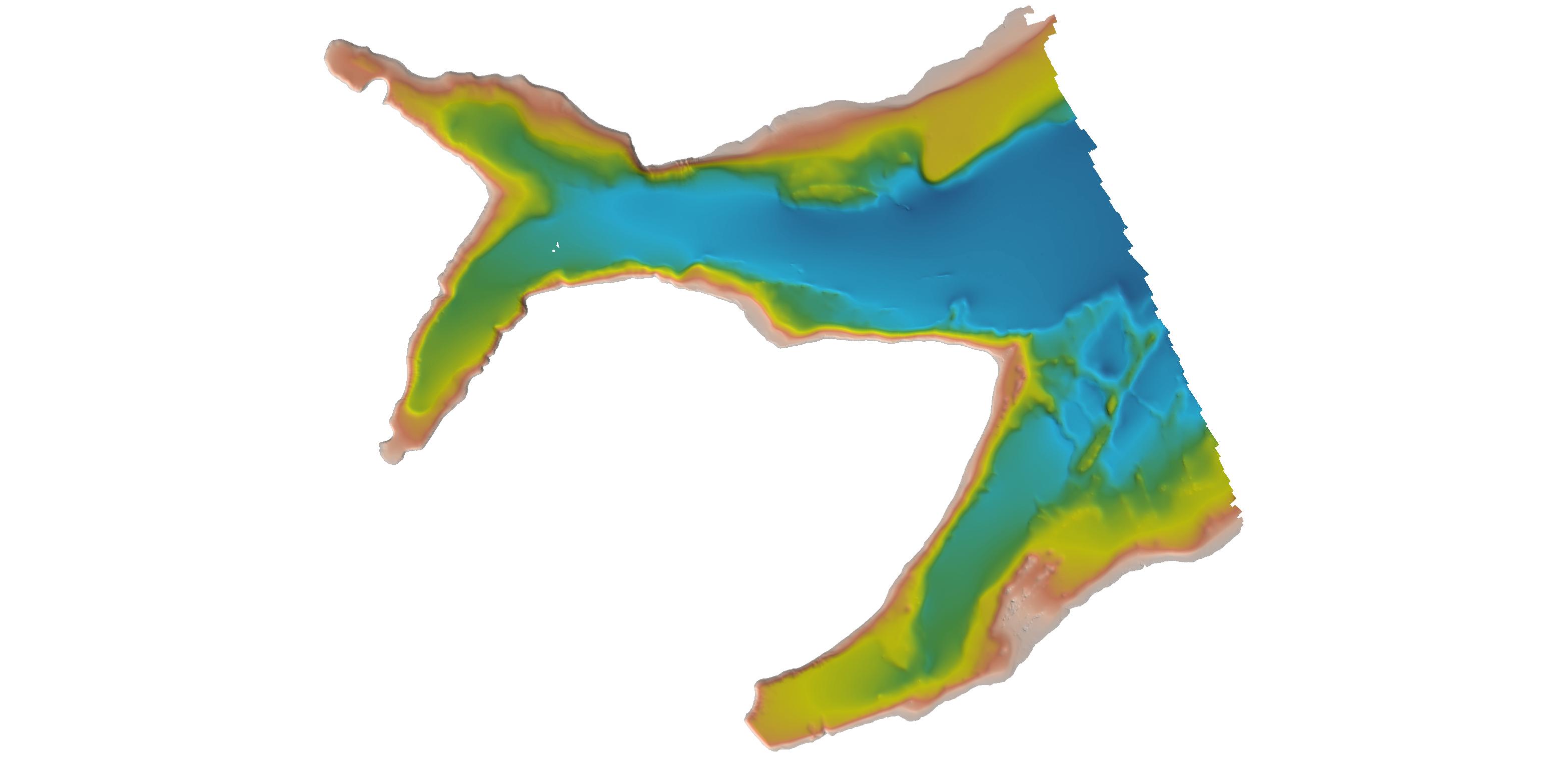
Federal
F00473D: NOS Hydrographic Survey , San Diego Bay, California, 2001-04-13
National Oceanic and Atmospheric Administration, Department of Commerce —
The National Oceanic and Atmospheric Administration (NOAA) has the statutory mandate to collect hydrographic data in support of nautical chart compilation for safe... -
Federal
H11195: NOS Hydrographic Survey , Southwest Alaska Peninsula, Alaska, 2003-06-06
National Oceanic and Atmospheric Administration, Department of Commerce —
The National Oceanic and Atmospheric Administration (NOAA) has the statutory mandate to collect hydrographic data in support of nautical chart compilation for safe... -
Federal
H13449: NOS Hydrographic Survey , 2021-07-21
National Oceanic and Atmospheric Administration, Department of Commerce —
The National Oceanic and Atmospheric Administration (NOAA) has the statutory mandate to collect hydrographic data in support of nautical chart compilation for safe... -
Federal
Wind Integration National Dataset (WIND) Toolkit - Multi-year Annual Average - Mexico
Department of Energy —
This data provides modeled annual average wind speed for Mexico and surrounding areas both onshore and offshore for the period 2007–2013. This dataset was derived... -
University
2012 Whitewater Baldy Post Fire, Rice Ranch SE NE, CIR
Earth Data Analysis Center, University of New Mexico —
This dataset contains imagery for the Gila National Forest, Catron and Grant County, New Mexico. The imagery was flown to provide coverage after the 2012 Whitewater-... -
Federal
H00133A: NOS Hydrographic Survey , 1841-10-19
National Oceanic and Atmospheric Administration, Department of Commerce —
The National Oceanic and Atmospheric Administration (NOAA) has the statutory mandate to collect hydrographic data in support of nautical chart compilation for safe... -
Federal
H00092: NOS Hydrographic Survey , 1839-10-03
National Oceanic and Atmospheric Administration, Department of Commerce —
The National Oceanic and Atmospheric Administration (NOAA) has the statutory mandate to collect hydrographic data in support of nautical chart compilation for safe... -
Federal
H13474: NOS Hydrographic Survey , 2021-10-07
National Oceanic and Atmospheric Administration, Department of Commerce —
The National Oceanic and Atmospheric Administration (NOAA) has the statutory mandate to collect hydrographic data in support of nautical chart compilation for safe... -
Federal
H13092: NOS Hydrographic Survey , 2017-11-09
National Oceanic and Atmospheric Administration, Department of Commerce —
The National Oceanic and Atmospheric Administration (NOAA) has the statutory mandate to collect hydrographic data in support of nautical chart compilation for safe... -
Federal
H04831: NOS Hydrographic Survey , 1927-12-31
National Oceanic and Atmospheric Administration, Department of Commerce —
The National Oceanic and Atmospheric Administration (NOAA) has the statutory mandate to collect hydrographic data in support of nautical chart compilation for safe... -
University
2011 Mayhill Post Fire Imagery, Mayhill SW NE, CIR
Earth Data Analysis Center, University of New Mexico —
This dataset contains imagery for the Lincoln National Forest. The imagery was flown to provide coverage after the 2011 Mayhill Fire. -
University
2011 Mayhill Post Fire Imagery, Mayhill NW NE, CIR
Earth Data Analysis Center, University of New Mexico —
This dataset contains imagery for the Lincoln National Forest. The imagery was flown to provide coverage after the 2011 Mayhill Fire. -
Federal
H01331A: NOS Hydrographic Survey , 1876-12-31
National Oceanic and Atmospheric Administration, Department of Commerce —
The National Oceanic and Atmospheric Administration (NOAA) has the statutory mandate to collect hydrographic data in support of nautical chart compilation for safe... -
Federal
2012 USDA Plant Hardiness Zone Map Mean Annual Extreme Low Temperature Rasters
Department of Agriculture —
These rasters provide the local mean annual extreme low temperature from 1976 to 2005 in an 800m x 800m grid covering the USA (including Puerto Rico) based on... -
Federal
Physical Solar Model version 3 Global Horizontal Irradiance Multi-year Monthly Average
Department of Energy —
This data provides monthly average daily total solar resource averaged over surface cells of 0.038 degrees in both latitude and longitude, or nominally 4 km in size....

Official websites use .gov
A
.gov website belongs to an official government
organization in the United States.
Secure .gov websites use HTTPS
A
lock (
) or https:// means you’ve safely connected to
the .gov website. Share sensitive information only on official,
secure websites.
.jpg)