
-
Federal
AIRSAR_TOPSAR_C-BAND_DEM_AND_STOKES
National Aeronautics and Space Administration —
AIRSAR topographic SAR digital elevation model C_Stokes product -
University
Coal Mine Permit Boundaries
Earth Data Analysis Center, University of New Mexico —
ESRI ArcView shapefile depicting New Mexico coal mines permitted under the Surface Mining Control and Reclamation Act of 1977 (SMCRA), by either the NM Mining &... -
Federal
AIRSAR_TOPSAR_DEM
National Aeronautics and Space Administration —
AIRSAR topographic SAR digital elevation model product -
Federal
BLM OR Mineral Stipulations Polygon Hub
Department of the Interior —
MINSTIP_POLY: This dataset applies to BLM-administered lands containing valuable minerals and categorized in the U.S Code of Federal Regulations or by official U.S.... -
Federal
BLM Idaho SW Montana Greater SageGrouse FINAL EIS Sagebrush Focal Areas 2015ROD Poly
Department of the Interior —
Sagebrush Focal Areas (SFAs) are a refinement of Greater Sage Grouse habitat delineating the most valuable habitat to the Greater Sage Grouse (Centrocercus... -
Federal
BLM Idaho SW Montana Greater SageGrouse FINAL EIS Winter Habitat
Department of the Interior —
Greater Sage-Grouse (Centrocercus urophasianus) Winter Habitat as mapped by the Idaho Department of Fish and Game (IDFG) for the Idaho and Southwestern Montana... -
Federal
Mining Camp, AK
National Oceanic and Atmospheric Administration, Department of Commerce —
Timeseries data from 'Mining Camp, AK' (noaa_nos_co_ops_9457671) -
Federal
Unpublished Digital Surficial Geologic-GIS Map of the Sandy Hook and Longbranch Quadrangles and Vicinity, New Jersey (NPS, GRD, GRI, GATE, SHSF digital map) adapted from a New Jersey Geological Survey Open-file Maps by Stanford, S.D. (1995, 1999, 2000, 2002)
Department of the Interior —
The Unpublished Digital Surficial Geologic-GIS Map of the Sandy Hook and Longbranch Quadrangles and Vicinity, New Jersey is composed of GIS data layers and GIS tables... -
Federal
AIRSAR_TOPSAR_DEM_C
National Aeronautics and Space Administration —
AIRSAR topographic SAR digital elevation model CTIF product -
Federal
BLM Idaho Greater SageGrouse Final EIS WAFWA Poly
Department of the Interior —
This data set depicts a preliminary version of the management zone boundaries for Greater and Gunnison sage-grouse in the western United States and Canada. These... -
Federal
H02770A: NOS Hydrographic Survey
National Oceanic and Atmospheric Administration, Department of Commerce —
The National Oceanic and Atmospheric Administration (NOAA) has the statutory mandate to collect hydrographic data in support of nautical chart compilation for safe... -
Federal
H12523: NOS Hydrographic Survey , 2013-08-22
National Oceanic and Atmospheric Administration, Department of Commerce —
The National Oceanic and Atmospheric Administration (NOAA) has the statutory mandate to collect hydrographic data in support of nautical chart compilation for safe... -
Federal
Pfaff Mine
National Oceanic and Atmospheric Administration, Department of Commerce —
Timeseries data from 'Pfaff Mine' (raws_akapfa) -
Federal
GREENS C AT GREENS CREEK MINE NR JUNEAU AK (USGS 15101490)
National Oceanic and Atmospheric Administration, Department of Commerce —
Timeseries data from 'GREENS C AT GREENS CREEK MINE NR JUNEAU AK (USGS 15101490)' (gov_usgs_nwis_15101490) -
Federal
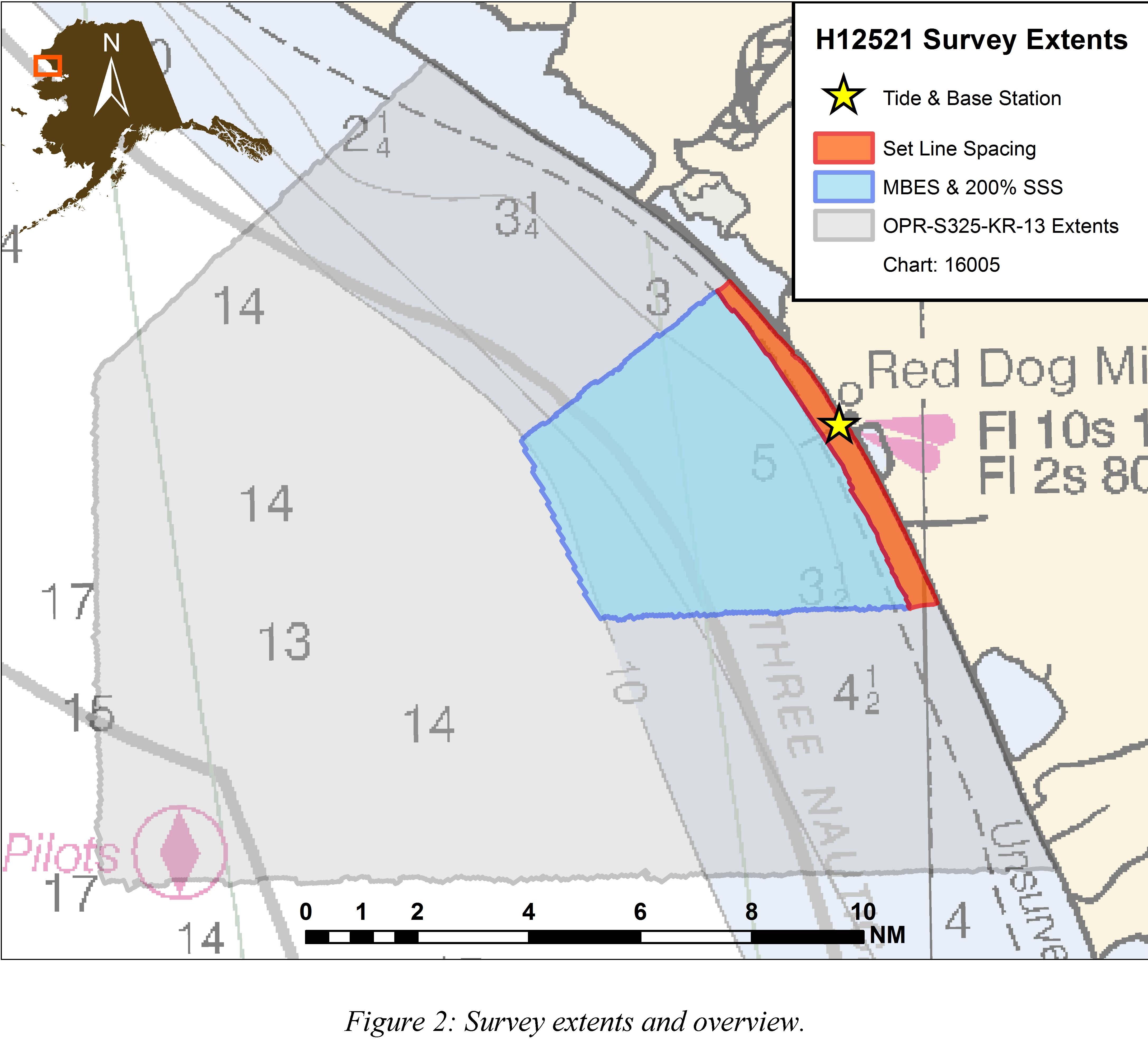
H12521: NOS Hydrographic Survey , 2013-08-22
National Oceanic and Atmospheric Administration, Department of Commerce —
The National Oceanic and Atmospheric Administration (NOAA) has the statutory mandate to collect hydrographic data in support of nautical chart compilation for safe... -
Federal
AIRSAR_TOPSAR_DEM_P
National Aeronautics and Space Administration —
AIRSAR topographic SAR digital elevation model PTIF product -
Federal
AIRSAR_TOPSAR_DEM_L
National Aeronautics and Space Administration —
AIRSAR topographic SAR digital elevation model LTIF product -
Federal
H02770: NOS Hydrographic Survey
National Oceanic and Atmospheric Administration, Department of Commerce —
The National Oceanic and Atmospheric Administration (NOAA) has the statutory mandate to collect hydrographic data in support of nautical chart compilation for safe... -
Federal
Ikalukrok Creek near Red Dog Mine
National Oceanic and Atmospheric Administration, Department of Commerce —
Timeseries data from 'Ikalukrok Creek near Red Dog Mine' (gov_noaa_water_ikaa2) -
Federal
CONTWOYTO LAKE AT LUPIN MINE
National Oceanic and Atmospheric Administration, Department of Commerce —
Timeseries data from 'CONTWOYTO LAKE AT LUPIN MINE' (ca_hydro_10QC003)

Official websites use .gov
A
.gov website belongs to an official government
organization in the United States.
Secure .gov websites use HTTPS
A
lock (
) or https:// means you’ve safely connected to
the .gov website. Share sensitive information only on official,
secure websites.