
-
Federal
F00595: NOS Hydrographic Survey , NW Approach to Key West, Florida, 2010-08-23
National Oceanic and Atmospheric Administration, Department of Commerce —
The National Oceanic and Atmospheric Administration (NOAA) has the statutory mandate to collect hydrographic data in support of nautical chart compilation for safe... -
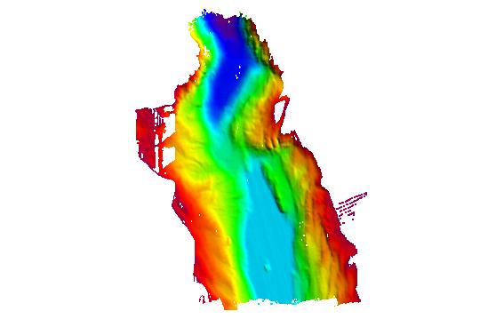
Federal
H12110: NOS Hydrographic Survey , San Fransisco Bay, California, 2009-08-03
National Oceanic and Atmospheric Administration, Department of Commerce —
The National Oceanic and Atmospheric Administration (NOAA) has the statutory mandate to collect hydrographic data in support of nautical chart compilation for safe... -
Federal
EnviroAtlas - Water Balance and Surficial Groundwater by 12-digit HUC for the Conterminous United States
U.S. Environmental Protection Agency —
This EnviroAtlas dataset summarizes several U.S. Geological Survey (USGS) water budget and surficial groundwater datasets by 12-digit HUC. It includes average rates... -
Federal
NLCD 2016 Land Cover Reference Data, Conterminous United States NGDA
U.S. Environmental Protection Agency —
The U.S. Geological Survey (USGS), in partnership with several federal agencies, has developed and released five National Land Cover Database (NLCD) products over the... -
Federal
H11517: NOS Hydrographic Survey , Southwestern Alaskan Peninsula, Alaska, 2006-06-15
National Oceanic and Atmospheric Administration, Department of Commerce —
The National Oceanic and Atmospheric Administration (NOAA) has the statutory mandate to collect hydrographic data in support of nautical chart compilation for safe... -
Federal
H11697: NOS Hydrographic Survey , Chatham Strait, Alaska, 2007-09-04
National Oceanic and Atmospheric Administration, Department of Commerce —
The National Oceanic and Atmospheric Administration (NOAA) has the statutory mandate to collect hydrographic data in support of nautical chart compilation for safe... -
Federal
H11873: NOS Hydrographic Survey , Mid-Atlantic Corridor, Maryland, 2008-12-18
National Oceanic and Atmospheric Administration, Department of Commerce —
The National Oceanic and Atmospheric Administration (NOAA) has the statutory mandate to collect hydrographic data in support of nautical chart compilation for safe... -
Federal
H11494: NOS Hydrographic Survey , Prince William Sound, Alaska, 2005-09-22
National Oceanic and Atmospheric Administration, Department of Commerce —
The National Oceanic and Atmospheric Administration (NOAA) has the statutory mandate to collect hydrographic data in support of nautical chart compilation for safe... -
City
Louisville KY HUD Grant Neighborhoods from 1979 (Urban Neighborhoods)
Louisville Metro Government —
The Louisville Neighborhoods layer consists of polygons representing approximate boundaries and extents of historical and cultural neighborhoods within the pre-... -
Federal
D00149: NOS Hydrographic Survey , Chatham Harbor and Approaches, Massachusetts, 2009-09-30
National Oceanic and Atmospheric Administration, Department of Commerce —
The National Oceanic and Atmospheric Administration (NOAA) has the statutory mandate to collect hydrographic data in support of nautical chart compilation for safe... -
University
GNIS: Buildings (2013)
Earth Data Analysis Center, University of New Mexico —
The Geographic Names Information System (GNIS) is the Federal standard for geographic nomenclature. The U.S. Geological Survey developed the GNIS for the U.S. Board... -
State
2D Building Footprints
State of Connecticut —
Connecticut Statewide Building footprints were created during the CT Statewide GIS Services lidar project. Building footprints are reviewed against lidar intensity... -
Federal
D00191: NOS Hydrographic Survey , 2014-05-03
National Oceanic and Atmospheric Administration, Department of Commerce —
The National Oceanic and Atmospheric Administration (NOAA) has the statutory mandate to collect hydrographic data in support of nautical chart compilation for safe... -
Federal
H11587: NOS Hydrographic Survey , Southwest Alaska Peninsula, Alaska, 2006-08-30
National Oceanic and Atmospheric Administration, Department of Commerce —
The National Oceanic and Atmospheric Administration (NOAA) has the statutory mandate to collect hydrographic data in support of nautical chart compilation for safe... -
Federal
D00183: NOS Hydrographic Survey , 2013-07-09
National Oceanic and Atmospheric Administration, Department of Commerce —
The National Oceanic and Atmospheric Administration (NOAA) has the statutory mandate to collect hydrographic data in support of nautical chart compilation for safe... -
Federal
H11738: NOS Hydrographic Survey , Northern California Coast, California, 2007-04-04
National Oceanic and Atmospheric Administration, Department of Commerce —
The National Oceanic and Atmospheric Administration (NOAA) has the statutory mandate to collect hydrographic data in support of nautical chart compilation for safe... -
County
Address Points
Lake County, Illinois —
Download In State Plane Projection Here. These address points were developed for a myriad of uses including general public geocoding in Lake County web sites and... -
Federal
W00155: NOS Hydrographic Survey , Outside Source Data Surveys - 2009, 2003-09-12
National Oceanic and Atmospheric Administration, Department of Commerce —
The National Oceanic and Atmospheric Administration (NOAA) has the statutory mandate to collect hydrographic data in support of nautical chart compilation for safe... -
Federal
F00793: NOS Hydrographic Survey , 2021-06-02
National Oceanic and Atmospheric Administration, Department of Commerce —
The National Oceanic and Atmospheric Administration (NOAA) has the statutory mandate to collect hydrographic data in support of nautical chart compilation for safe... -
University
Soil Survey Geographic (SSURGO) database for Cabezon Area, New Mexico (Sandoval County, New Mexico)
Earth Data Analysis Center, University of New Mexico —
This data set is a digital soil survey and generally is the most detailed level of soil geographic data developed by the National Cooperative Soil Survey. The...

Official websites use .gov
A
.gov website belongs to an official government
organization in the United States.
Secure .gov websites use HTTPS
A
lock (
) or https:// means you’ve safely connected to
the .gov website. Share sensitive information only on official,
secure websites.
.jpg)