
-
Federal
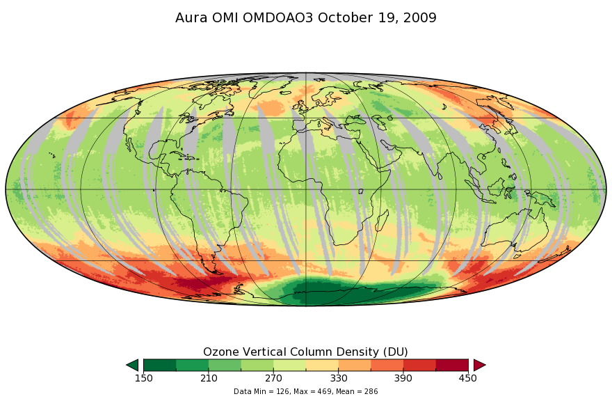
OMI/Aura Ozone (O3) DOAS Total Column Daily L3 1 day 0.25 degree x 0.25 degree V3 (OMDOAO3e) at GES DISC recent views
National Aeronautics and Space Administration —
The OMI science team produces this Level-3 Aura/OMI Global OMDOAO3e Data Products (0.25deg Lat/Lon grids). This Level-3 global total column ozone product is derived... -
Federal
NCEP/CPC L3 Half Hourly 4km Global (60S - 60N) Merged IR V1 (GPM_MERGIR) at GES DISC recent views
National Aeronautics and Space Administration —
These data originate from NOAA/NCEP. The NOAA Climate Prediction Center/NCEP/NWS is making the data available originally in binary format, in a weekly rotating... -
Federal
GEOS-5 FP-IT 3D Time-Averaged Model-Layer Assimilated Data Geo-Colocated to OMI/Aura UV2 1-Orbit L2 Swath 13x24km V4 (OMUFPMET) at GES DISC recent views
National Aeronautics and Space Administration —
The GEOS-5 FP-IT 3D Time-Averaged Model-Layer Assimilated Data Geo-Colocated to OMI/Aura UV2 1-Orbit L2 Swath 13x24km (OMUFPMET) product provides selected... -
Federal
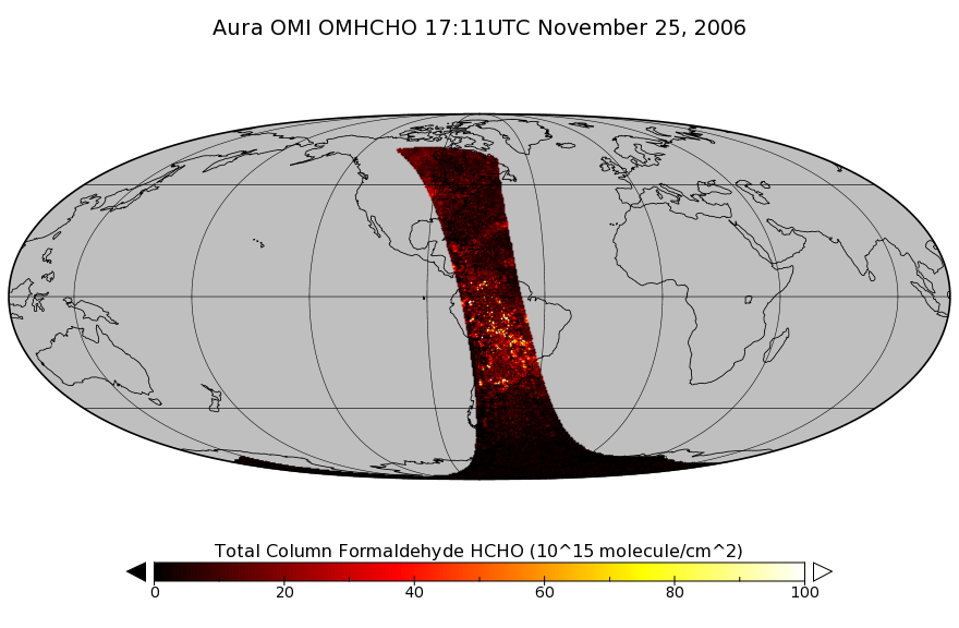
OMI/Aura Formaldehyde (HCHO) Total Column 1-orbit L2 Swath 13x24 km V003 (OMHCHO) at GES DISC recent views
National Aeronautics and Space Administration —
The Aura Ozone Monitoring Instrument (OMI) Version-3 Formaldehyde Product OMHCHO is now available from the NASA Goddard Earth Sciences Data and Information Services... -
Federal
OMI/Aura and MODIS/Aqua Merged Cloud Product 1-Orbit L2 Swath 13x24 km V003 (OMMYDCLD) at GES DISC NGDA recent views
National Aeronautics and Space Administration —
The OMI/Aura and MODIS/Aqua Merged Cloud Product 1-Orbit L2 Swath 13x24 km (OMMYDCLD) is a Level-2 orbital product that combines cloud parameters retrieved by the... -
Federal
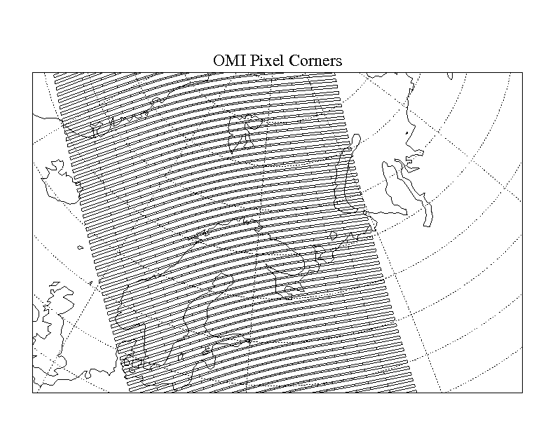
OMI/Aura Global Ground Pixel Corners 1-Orbit L2 Swath 13x24km V003 (OMPIXCOR) at GES DISC recent views
National Aeronautics and Space Administration —
The Version-3 Aura Ozone Monitoring Instrument (OMI) Pixel Corner Product, OMPIXCOR, is now available from the NASA Goddard Earth Sciences Data and Information... -
Federal
GEOS-5 FP-IT 3D Time-Averaged Model-Layer Assimilated Data Geo-Colocated to OMI/Aura VIS 1-Orbit L2 Swath 13x24km V4 (OMVFPMET) at GES DISC recent views
National Aeronautics and Space Administration —
The GEOS-5 FP-IT 3D Time-Averaged Model-Layer Assimilated Data Geo-Colocated to OMI/Aura VIS 1-Orbit L2 Swath 13x24km (OMVFPMET) product provides selected... -
Federal
HAQAST Sentinel-5P TROPOMI Nitrogen Dioxide (NO2) CONUS Monthly Level 3 0.01 x 0.01 Degree Gridded Data V2.4 (HAQ_TROPOMI_NO2_CONUS_M_L3) at GES DISC recent views
National Aeronautics and Space Administration —
This product provides level 3 monthly averages of tropospheric Nitrogen dioxide (NO2) vertical column density derived from the level 2 Tropospheric Monitoring... -
Federal
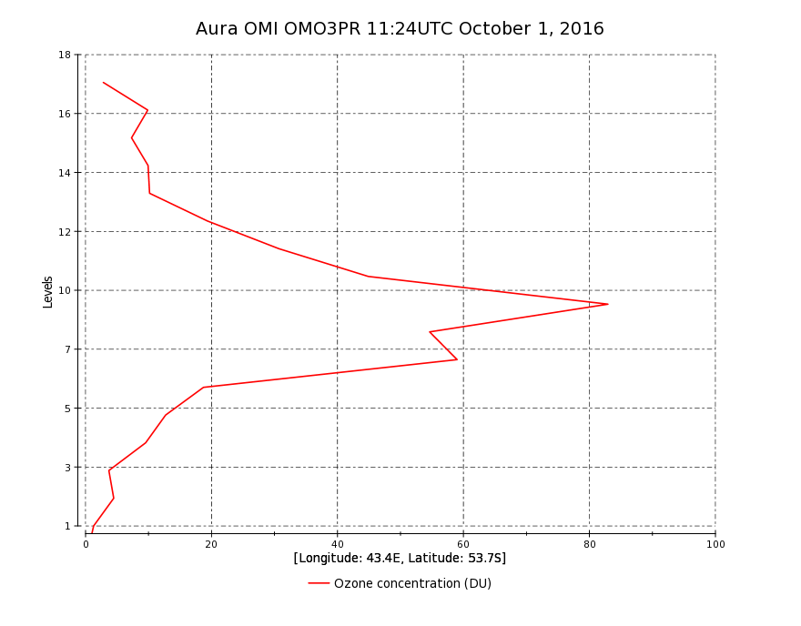
OMI/Aura Ozone (O3) Profile 1-Orbit L2 Swath 13x48km V003 (OMO3PR) at GES DISC recent views
National Aeronautics and Space Administration —
The Aura Ozone Monitoring Instrument Level-2 Ozone Profile data product OMO3PR (Version 003) is now available from the NASA Goddard Earth Sciences Data and... -
Federal
LPJ-PROSAIL L2 Global Simulated Dynamic Surface Reflectance V001 recent views
National Aeronautics and Space Administration —
LPJ-PROSAIL simulated data products are produced through the coupling of the Lund-Potsdam-Jena dynamic global vegetation model (LPJ) and PROSAIL, a radiative transfer... -
Federal
GEOS-5 FP-IT 3D Time-Averaged Single-Level Diagnostics Geo-Colocated to OMI/Aura VIS 1-Orbit L2 Swath 13x24km V4 (OMVFPSLV) at GES DISC recent views
National Aeronautics and Space Administration —
The GEOS-5 FP-IT 3D Time-Averaged Single-Level Diagnostics Geo-Colocated to OMI/Aura VIS 1-Orbit L2 Swath 13x24km (OMVFPSLV) provides selected parameters from GEOS-5... -
Federal
OMI/Aura Level 1B VIS Global Geolocated Earth Shine Radiances 1-orbit L2 Swath 13x24 km V003 (OML1BRVG) at GES DISC recent views
National Aeronautics and Space Administration —
The Aura Ozone Monitoring Instrument (OMI) Level-1B (L1B) Geo-located Earth View VIS Radiance, Global-Mode (OML1BRVG) Version-3 product contains geo-located Earth... -
Federal
OMI/Aura Zoom-in Ground Pixel Corners 1-Orbit L2 Swath 13x12km V003 (OMPIXCORZ) at GES DISC recent views
National Aeronautics and Space Administration —
The Version-3 Aura Ozone Monitoring Instrument (OMI) Pixel Corner Product in zoom-in mode, OMPIXCORZ, is now available from the NASA Goddard Earth Sciences Data and... -
Federal
HAQAST Sentinel-5P TROPOMI Nitrogen Dioxide (NO2) CONUS Seasonal Level 3 0.01 x 0.01 Degree Gridded Data V2.4 (HAQ_TROPOMI_NO2_CONUS_S_L3) at GES DISC recent views
National Aeronautics and Space Administration —
This product provides level 3 seasonal averages of tropospheric Nitrogen dioxide (NO2) vertical column density derived from the level 2 Tropospheric Monitoring... -
Federal
OMI/Aura Ozone(O3) Total Column 1-Orbit L2 Swath 13x24 km V003 (OMTO3) at GES DISC recent views
National Aeronautics and Space Administration —
The Aura Ozone Monitoring Instrument (OMI) Level-2 Total Column Ozone Data Product OMTO3 (Version 003) is available from the NASA Goddard Earth Sciences Data and... -
Federal
OMI/Aura Sulphur Dioxide (SO2) Total Column 1-orbit L2 Swath 13x24 km V003 (OMSO2) at GES DISC recent views
National Aeronautics and Space Administration —
The Aura Ozone Monitoring Instrument (OMI) level 2 sulphur dioxide (SO2) total column product (OMSO2) has been updated with a principal component analysis (PCA)-based... -
Federal
ISLSCP II Ecosystem Rooting Depths NGDA recent views
National Aeronautics and Space Administration —
The goal of this study was to predict the global distribution of plant rooting depths based on data about global aboveground vegetation structure and climate.... -
Federal
HAQAST Sentinel-5P TROPOMI Nitrogen Dioxide (NO2) GLOBAL Monthly Level 3 0.1 x 0.1 Degree Gridded Data Version 2.4 (HAQ_TROPOMI_NO2_GLOBAL_M_L3) at GES DISC recent views
National Aeronautics and Space Administration —
This product provides level 3 monthly averages of tropospheric Nitrogen dioxide (NO2) vertical column density derived from the level 2 Tropospheric Monitoring... -
Federal
HAQAST Sentinel-5P TROPOMI Nitrogen Dioxide (NO2) CONUS Annual Level 3 0.01 x 0.01 Degree Gridded Data V2.4 (HAQ_TROPOMI_NO2_CONUS_A_L3) at GES DISC recent views
National Aeronautics and Space Administration —
This product provides level 3 annual averages of tropospheric Nitrogen dioxide (NO2) vertical column density derived from the level 2 Tropospheric Monitoring... -
Federal
LBA Regional Carbon in Live Vegetation, 0.5-degree (Olson) recent views
National Aeronautics and Space Administration —
This data set is a subset of Olson et al. (1985, 2000) "Major World Ecosystem Complexes Ranked by Carbon in Live Vegetation." This subset was created for the study...

Official websites use .gov
A
.gov website belongs to an official government
organization in the United States.
Secure .gov websites use HTTPS
A
lock (
) or https:// means you’ve safely connected to
the .gov website. Share sensitive information only on official,
secure websites.