
-
Federal
NCEI/WDS Global Historical Tsunami Database, 2100 BC to Present
National Oceanic and Atmospheric Administration, Department of Commerce —
The Global Historical Tsunami Database provides information on over 2,400 tsunamis from 2100 BC to the present in the the Atlantic, Indian, and Pacific Oceans; and... -
Federal
Deep-Ocean Assessment and Reporting of Tsunamis (DART(R))
National Oceanic and Atmospheric Administration, Department of Commerce —
As part of the U.S. National Tsunami Hazard Mitigation Program (NTHMP), the Deep Ocean Assessment and Reporting of Tsunamis (DART(R)) Project is an ongoing effort to... -
Federal
Global Earthquake Proportional Economic Loss Risk Deciles
National Aeronautics and Space Administration —
The Global Earthquake Proportional Economic Loss Risk Deciles is a 2.5 minute grid of earthquake hazard economic loss as proportions of Gross Domestic Product (GDP)... -
Federal
Archival and Discovery of April 1, 1946 Tsunami Event on Marigrams
National Oceanic and Atmospheric Administration, Department of Commerce —
NOAA National Centers for Environmental Information have more than 3,000 tsunami marigram (tide gauge) records in both image and paper format. The majority of these... -
Federal
Archival and Discovery of May 16, 1968 Tsunami Event on Marigrams
National Oceanic and Atmospheric Administration, Department of Commerce —
NOAA National Centers for Environmental Information have more than 3,000 tsunami marigram (tide gauge) records in both image and paper format. The majority of these... -
Federal
Archival and Discovery of March 2, 1933 Tsunami Event on Marigrams
National Oceanic and Atmospheric Administration, Department of Commerce —
NOAA National Centers for Environmental Information have more than 3,000 tsunami marigram (tide gauge) records in both image and paper format. The majority of these... -
Federal
Archival and Discovery of November 27, 1945 Tsunami Event on Marigrams
National Oceanic and Atmospheric Administration, Department of Commerce —
These water level data were digitized from a scanned marigram image associated with the tsunami event of 1945-11-27 at a tide gauge located at Karachi, Pakistan, and... -
Federal
Archival and Discovery of December 23, 1854 Tsunami Event on Marigrams
National Oceanic and Atmospheric Administration, Department of Commerce —
NOAA National Centers for Environmental Information have more than 3,000 tsunami marigram (tide gauge) records in both image and paper format. The majority of these... -
Federal
Archival and Discovery of June 15, 1896 Tsunami Event on Marigrams
National Oceanic and Atmospheric Administration, Department of Commerce —
NOAA National Centers for Environmental Information have more than 3,000 tsunami marigram (tide gauge) records in both image and paper format. The majority of these... -
Federal
Archival and Discovery of August 27, 1883 Tsunami Event on Marigrams
National Oceanic and Atmospheric Administration, Department of Commerce —
NOAA National Centers for Environmental Information have more than 3,000 tsunami marigram (tide gauge) records in both image and paper format. The majority of these... -
Federal
CDDIS SESES MEaSUREs products seismodetic for M>6 earthquakes
National Aeronautics and Space Administration —
Making Earth System Data Records for Use in Research Environments (MEaSUREs) empowers the research community to participate in developing and generating data products... -
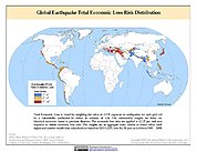
Federal
Global Earthquake Total Economic Loss Risk Deciles
National Aeronautics and Space Administration —
The Global Earthquake Total Economic Loss Risk Deciles is a 2.5 minute grid of global earthquake total economic loss risks. A process of spatially allocating Gross...

Official websites use .gov
A
.gov website belongs to an official government
organization in the United States.
Secure .gov websites use HTTPS
A
lock (
) or https:// means you’ve safely connected to
the .gov website. Share sensitive information only on official,
secure websites.