
-
Federal
NOAA Electronic Navigational Charts (ENC) NGDA
National Oceanic and Atmospheric Administration, Department of Commerce —
The Office of Coast Survey (OCS) has been involved in the development of a NOAA Electronic Navigational Chart (NOAA ENC) suite to support the marine transportation... -
Federal
Deep-Ocean Assessment and Reporting of Tsunamis (DART(R))
National Oceanic and Atmospheric Administration, Department of Commerce —
As part of the U.S. National Tsunami Hazard Mitigation Program (NTHMP), the Deep Ocean Assessment and Reporting of Tsunamis (DART(R)) Project is an ongoing effort to... -
City
National Flood Hazard - Cross Sections
Louisville Metro Government —
Normally, any FIRM that has associated flood profiles has cross sections. The S_XS table contains information about cross section lines. These lines usually... -
Federal
Refugio Marine Mammal Survey (June 3, 2015)
National Oceanic and Atmospheric Administration, Department of Commerce —
On May 19, 2015, a pipeline owned ruptured in Santa Barbara County, California, near Refugio State Beach. An estimated 21,000 gallons of the oil flowed overland from... -
Food Waste Drop Off
District of Columbia —
The locations of farmers' markets and unstaffed Smart Bin participating in the Department of Public Works' (DPW) Food Waste Drop-Off program. District residents may... -
Federal
NOAA Next Generation Radar (NEXRAD) Level 3 Products
National Oceanic and Atmospheric Administration, Department of Commerce —
This dataset consists of Level 3 weather radar products collected from Next-Generation Radar (NEXRAD) stations located in the contiguous United States, Alaska,... -
City
National Flood Hazard - FIRM Panels
Louisville Metro Government —
The S_FIRM_Pan table contains information about the FIRM panel area. A spatial file with location information also corresponds with this data table. The spatial... -
Federal
EPA RE-Powering Mapper Large Scale
U.S. Environmental Protection Agency —
The U.S. Environmental Protection Agency (EPA) Office of Land and Emergency Management (OLEM) Office of Communications, Partnerships and Analysis (OCPA) initiated the... -
State
Landfills
Vermont Center for Geographic Information —
This data set defines both current and historic landfills/waste disposal storage sites for the State of Vermont. Historic landfills were identified with the... -
Federal
Cleanups In My Community (CIMC) - Hazardous Waste Corrective Actions, National Layer
U.S. Environmental Protection Agency —
This data layer provides access to Hazardous Waste Corrective Action sites as part of the CIMC web service. Hazardous waste is waste that is dangerous or potentially... -
City
National Flood Hazard - Letter of Map Revision (LOMR)
Louisville Metro Government —
The S_LOMR feature class should contain at least one record for each Letter of Map Revision incorporated into the NFHL. Multipart polygons are not allowed. The... -
Federal
Cleanups In My Community (CIMC) - Federal Facility RCRA Sites, National Layer
U.S. Environmental Protection Agency —
Federal facilities are properties owned by the federal government. This data layer provides access to Federal facilities that are Resource Conservation and Recovery... -
Federal
Cleanups In My Community (CIMC) - Superfund National Priority List (NPL) Sites, National Layer
U.S. Environmental Protection Agency —
This data layer provides access to Superfund National Priority List Sites as part of the CIMC web service. Superfund is a program administered by the EPA to locate,... -
Federal
Near-real-time surface ocean velocities derived from HF-radar stations located along coastal waters of North Slope Alaska, Gulf of Alaska, Puerto Rico/Virgin Islands, eastern U.S./Gulf of America, Hawaii, Great Lakes, and western U.S.
National Oceanic and Atmospheric Administration, Department of Commerce —
This dataset contains near-real-time ocean surface velocities, also known as total vector velocities, derived from high-frequency (HF) radar stations. The velocities... -
Federal
Terrestrial Condition Assessment (TCA) Insect and Disease Hazard
Department of Agriculture —
Direct Download (Raster Data Gateway)Objective: Identify areas with unhealthy forest conditions as evidenced by a combination of stand and environmental... -
Trash and Recycling Collection Points
District of Columbia —
The DPW Point of Collection datasets provide comprehensive information essential for managing waste and recycling services. These datasets include detailed geographic... -
State
Hazardous Materials Storage Sites
State of Oregon —
This dataset contains lat/long mapping coordinates to verify addresses for the Oregon State Fire Marshal (OSFM) – Community Right to Know (CR2K), CHS Manager... -
Federal
Refugio Marine Mammal Survey (June 5, 2015)
National Oceanic and Atmospheric Administration, Department of Commerce —
On May 19, 2015, a pipeline owned ruptured in Santa Barbara County, California, near Refugio State Beach. An estimated 21,000 gallons of the oil flowed overland from... -
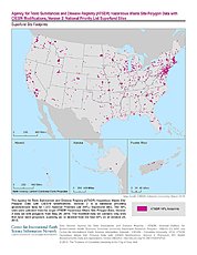
Federal
ATSDR Hazardous Waste Site Polygon Data with CIESIN Modifications, Version 2
National Aeronautics and Space Administration —
The Agency for Toxic Substances and Disease Registry (ATSDR) Hazardous Waste Site Polygon Data with CIESIN Modifications, Version 2 is a database providing...

Official websites use .gov
A
.gov website belongs to an official government
organization in the United States.
Secure .gov websites use HTTPS
A
lock (
) or https:// means you’ve safely connected to
the .gov website. Share sensitive information only on official,
secure websites.