

7 datasets found for "Deforestation"
-
Federal
NCCOS Assessment: Prescribed Fire in Coastal Alabama and Mississippi, 1992-01-01 to 2022-12-31
National Oceanic and Atmospheric Administration, Department of Commerce —
This dataset includes smoke and prescribed fire density from the National Centers for Coastal Ocean Science (NCCOS) Social Science team's Prescribed Fire project in... -
Federal
Spaceborne Imaging Radar-C Precision
National Aeronautics and Space Administration —
Spaceborne Imaging Radar-C/X-band Synthetic Aperture Radar (SIR-C/X-SAR) is a joint project of the National Aeronautics and Space Administration (NASA), the German... -
Federal
Millennium Ecosystem Assessment: MA Rapid Land Cover Change
National Aeronautics and Space Administration —
The Millennium Ecosystem Assessment: MA Rapid Land Cover Change provides data and information on global and regional land cover change in raster format for... -
Federal
NASA Landsat Data Collection
National Aeronautics and Space Administration —
The NASA Landsat Data Collection (NLDC) is a compilation of Landsat multispectral scanner (MSS) scenes and Landsat thematic mapper (TM) scenes. This compilation of... -
Federal
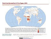
Global Fire Emissions Indicators, Country-Level Tabular Data: 1997-2015
National Aeronautics and Space Administration —
The Global Fire Emissions Indicators, Country-Level Tabular Data: 1997-2015 contains country tabulations from 1997 to 2015 for the total area burned (hectares) and... -
Federal
West Africa Coastal Vulnerability Mapping: Deforestation, 2000-2012
National Aeronautics and Space Administration —
The West Africa Coastal Vulnerability Mapping: Deforestation, 2000-2012, layer was created from the Global Forest Change data set which represents global tree cover...
7 datasets found for "Deforestation"