
-
Federal
Hydrodynamic and Sediment Transport Model Application for OSAT3 Guidance: Ratio of the wave- and current-induced shear stress to the critical value for oil-tar balls and sediment mobilization over a tidal cycle
Department of the Interior —
The U.S. Geological Survey has developed a method for estimating the mobility and potential alongshore transport of heavier-than-water sand and oil agglomerates... -
Federal
Annual marbled murrelet abundance and productivity surveys off central California (Zone 6), 1999-2021
Department of the Interior —
Since 2017, U.S. Geological Survey, Western Ecological Research Center (USGS WERC) partnered with California State Parks to continue long-term, annual at-sea surveys... -
Federal
Water temperature data to support effectiveness monitoring of channel and floodplain restoration projects along the Willamette River, Oregon: Minto-Brown Island Park 2020-2021
Department of the Interior —
Continuous water temperature data were collected at multiple sites along the Middle Fork and mainstem Willamette Rivers between Jasper and Newberg, Oregon, to support... -
Federal
Tidal_Grid
Department of the Interior —
The U.S. Geological Survey has developed a method for estimating the mobility and potential alongshore transport of heavier-than-water sand and oil agglomerates... -
Federal
Wave and wind projections along United States coasts
Department of the Interior —
Coastal managers and ocean engineers rely heavily on projected average and extreme wave conditions for planning and design purposes, but when working on a local or... -
Federal
Process-guided deep learning water temperature predictions: 4b Sparkling Lake detailed training data
Department of the Interior —
This dataset includes compiled water temperature data from an instrumented buoy on Sparkling Lake, WI and discrete (manually sampled) water temperature records from... -
Federal
Modeled nearshore wave parameters
Department of the Interior —
This portion of the USGS data release contains simulated nearshore wave parameters derived from a stand-alone spectral wave model of the Columbia River littoral cell,... -
Federal
Process-guided deep learning water temperature predictions: 4a Lake Mendota detailed training data
Department of the Interior —
This dataset includes compiled water temperature data from an instrumented buoy on Lake Mendota, WI and discrete (manually sampled) water temperature records from... -
Federal
Groundwater and Tidal Time-Series Data, Bremerton Naval Complex, Bremerton Washington
Department of the Interior —
This data release includes time series data collected at the Bremerton Naval Complex, Bremerton WA. Groundwater levels and water quality parameters in two monitoring... -
Federal
Hourly wave-height observations from 2013 to 2017 at 32 sites throughout the Channel Islands National Park and San Nicolas Island
Department of the Interior —
Hourly wave-height observations at 32 sites throughout the Channel Islands National Park and San Nicolas Island, site-specific hind casts from the Coastal Data... -
Federal
Nearshore waves in southern California: hindcast, and modeled historical and 21st-century projected time series
Department of the Interior —
Abstract: This data release presents modeled time series of nearshore waves along the southern California coast, from Point Conception to the Mexican border,... -
Federal
Hydrodynamic and Sediment Transport Model Application for OSAT3 Guidance: Surf-zone integrated alongshore potential flux for oil-sand balls of varying sizes weighted by probability of wave scenario occurrence
Department of the Interior —
The U.S. Geological Survey has developed a method for estimating the mobility and potential alongshore transport of heavier-than-water sand and oil agglomerates... -
Federal
FIIS_Breach_Shorelines.shp - Fire Island National Seashore Wilderness Breach Shoreline Data Collected from Fire Island, New York, October 2014 to October 2017
Department of the Interior —
Hurricane Sandy made U.S. landfall, coincident with astronomically high tides, near Atlantic City, New Jersey, on October 29, 2012. The storm, the largest on... -
Federal
Process-guided deep learning water temperature predictions: 6b Sparkling Lake detailed evaluation data
Department of the Interior —
This dataset includes "test data" compiled water temperature data from an instrumented buoy on Sparkling Lake, WI and discrete (manually sampled) water temperature... -
Federal
Hydrodynamic and Sediment Transport Model Application for OSAT3 Guidance: wave direction
Department of the Interior —
The U.S. Geological Survey has developed a method for estimating the mobility and potential alongshore transport of heavier-than-water sand and oil agglomerates... -
Federal
H12804: NOS Hydrographic Survey , 2015-06-08
National Oceanic and Atmospheric Administration, Department of Commerce —
The National Oceanic and Atmospheric Administration (NOAA) has the statutory mandate to collect hydrographic data in support of nautical chart compilation for safe... -
Federal
H12794: NOS Hydrographic Survey , 2015-07-19
National Oceanic and Atmospheric Administration, Department of Commerce —
The National Oceanic and Atmospheric Administration (NOAA) has the statutory mandate to collect hydrographic data in support of nautical chart compilation for safe... -
Federal
H12767: NOS Hydrographic Survey , 2015-11-07
National Oceanic and Atmospheric Administration, Department of Commerce —
The National Oceanic and Atmospheric Administration (NOAA) has the statutory mandate to collect hydrographic data in support of nautical chart compilation for safe... -
Federal
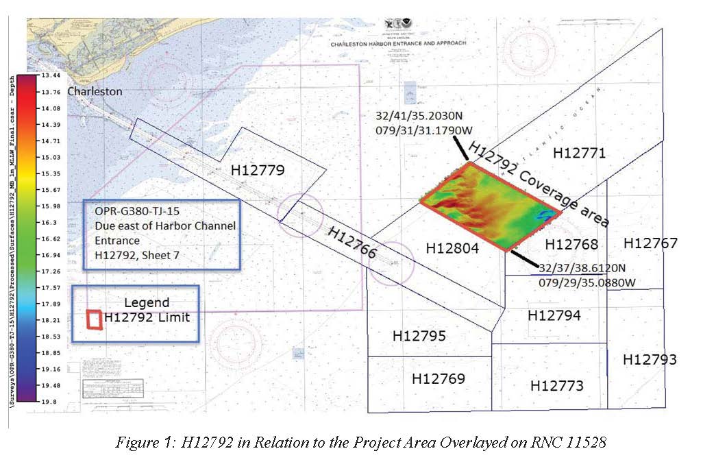
H12792: NOS Hydrographic Survey , 2015-06-16
National Oceanic and Atmospheric Administration, Department of Commerce —
The National Oceanic and Atmospheric Administration (NOAA) has the statutory mandate to collect hydrographic data in support of nautical chart compilation for safe... -
Federal
H12795: NOS Hydrographic Survey , 2015-05-30
National Oceanic and Atmospheric Administration, Department of Commerce —
The National Oceanic and Atmospheric Administration (NOAA) has the statutory mandate to collect hydrographic data in support of nautical chart compilation for safe...

Official websites use .gov
A
.gov website belongs to an official government
organization in the United States.
Secure .gov websites use HTTPS
A
lock (
) or https:// means you’ve safely connected to
the .gov website. Share sensitive information only on official,
secure websites.