
-
Federal
Global Reservoir and Dam Database, Version 1 (GRanDv1): Dams, Revision 01
National Aeronautics and Space Administration —
The Global Reservoir and Dam Database, Version 1, Revision 01 (v1.01) contains 6,862 records of reservoirs and their associated dams with a cumulative storage... -
Federal
Global Gridded Geographically Based Economic Data (G-Econ), Version 4
National Aeronautics and Space Administration —
The Global Gridded Geographically Based Economic Data (G-Econ), Version 4 contains derived one degree grid cells of Gross Domestic Product (GDP) data in Grid and... -
Federal
Natural Resource Management Index (NRMI), 2010 Release
National Aeronautics and Space Administration —
The Natural Resource Management Index (NRMI), 2010 Release is a composite index for 157 countries derived from the average of four proximity-to-target indicators for... -
Federal
West Africa Coastal Vulnerability Mapping: Point and Gridded Locations of Fatalities, 2008-2013
National Aeronautics and Space Administration —
The West Africa Coastal Vulnerability Mapping: Point and Gridded Locations of Fatalities, 2008-2013 data set consists of two layers: points representing the location... -
Federal
Archive of Census Related Products (ACRP): 1980 SAS Transport Files
National Aeronautics and Space Administration —
The 1980 SAS Transport Files portion of the Archive of Census Related Products (ACRP) contains housing and population demographics from the 1980 Summary Tape File... -
Federal
Global Reservoir and Dam Database, Version 1 (GRanDv1): Reservoirs, Revision 01
National Aeronautics and Space Administration —
Global Reservoir and Dam Database, Version 1, Revision 01 (v1.01) contains 6,862 records of reservoirs and their associated dams with a cumulative storage capacity of... -
Federal
Global Fertilizer and Manure, Version 1: Phosphorus in Manure Production
National Aeronautics and Space Administration —
The Phosphorus in Manure Production data set of the Global Fertilizer and Manure, Version 1 Data Collection represents the amount of phosphorous in manure produced... -
Federal
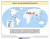
Global Earthquake Mortality Risks and Distribution
National Aeronautics and Space Administration —
The Global Earthquake Mortality Risks and Distribution is a 2.5 minute grid of global earthquake mortality risks. Gridded Population of the World, Version 3 (GPWv3)... -
Federal
2012 Environmental Performance Index and Pilot Trend Environmental Performance Index
National Aeronautics and Space Administration —
The 2012 Environmental Performance Index (EPI) ranks 132 countries on 22 performance indicators in the following 10 policy categories: environmental burden of... -
Federal
SDG Indicator 11.2.1: Urban Access to Public Transport, 2023 Release
National Aeronautics and Space Administration —
The SDG Indicator 11.2.1: Urban Access to Public Transport, 2023 Release, part of the SDGI collection, measures the proportion of the population in a city that has... -
Federal
Effects of Climate Change on Global Food Production from SRES Emissions and Socioeconomic Scenarios
National Aeronautics and Space Administration —
The Effects of Climate Change on Global Food Production from SRES Emissions and Socioeconomic Scenarios is an update to a major crop modeling study by the NASA... -
Federal
Groundswell Spatial Population and Migration Projections at One-Eighth Degree According to SSPs and RCPs, 2010-2050
National Aeronautics and Space Administration —
The Groundswell Spatial Population and Migration Projections at One-Eighth Degree According to SSPs and RCPs, 2010-2050, data set provides a baseline population... -
Federal
Water Security Indicator Model - Global Land Data Assimilation System (WSIM-GLDAS) Monthly Grids, Version 1
National Aeronautics and Space Administration —
The Water Security Indicator Model - Global Land Data Assimilation System (WSIM-GLDAS) Monthly Grids, Version 1 data set identifies and characterizes surpluses and... -
Federal
Central American Vegetation/Land Cover Classification and Conservation Status
National Aeronautics and Space Administration —
The Central American Vegetation/Land Cover Classification and Conservation Status consists of GIS coverages of vegetation classes (forests, woodlands, savannas,... -
Federal
Altimeter Corrected Elevations, Version 2 (ACE2)
National Aeronautics and Space Administration —
The Altimeter Corrected Elevations, Version 2 (ACE2) data set, is the Global Digital Elevation Model (GDEM) created by using multi-mission Satellite Radar Altimetry... -
Federal
Global Urban Heat Island (UHI) Data Set, 2013
National Aeronautics and Space Administration —
The Urban Heat Island (UHI) effect represents the relatively higher temperatures found in urban areas compared to surrounding rural areas owing to higher proportions... -
Federal
Gridded Population of the World, Version 4 (GPWv4): Population Density, Revision 11
National Aeronautics and Space Administration —
The Gridded Population of the World, Version 4 (GPWv4): Population Density, Revision 11 consists of estimates of human population density (number of persons per... -
Federal
Global Human Modification of Terrestrial Systems
National Aeronautics and Space Administration —
The Global Human Modification of Terrestrial Systems data set provides a cumulative measure of the human modification of terrestrial lands across the globe at a 1-km... -
Federal
Global Pesticide Grids (PEST-CHEMGRIDS), Version 1.01
National Aeronautics and Space Administration —
The Global Pesticide Grids (PEST-CHEMGRIDS), Version 1.01 data set contains 20 of the most-used pesticide active ingredients on 6 dominant crops and 4 aggregated crop... -
Federal
SDG Indicator 11.7.1: Urban Public Space, Availability and Access, 2023 Release
National Aeronautics and Space Administration —
The SDG Indicator 11.7.1: Urban Public Space, Availability and Access, 2023 Release, part of the SDGI collection, measures the average share of the built-up area of a...

Official websites use .gov
A
.gov website belongs to an official government
organization in the United States.
Secure .gov websites use HTTPS
A
lock (
) or https:// means you’ve safely connected to
the .gov website. Share sensitive information only on official,
secure websites.