
-
Federal
ISLSCP II Ecosystem Rooting Depths NGDA recent views
National Aeronautics and Space Administration —
The goal of this study was to predict the global distribution of plant rooting depths based on data about global aboveground vegetation structure and climate.... -
Federal
Pre-LBA Rondonia Boundary Layer Experiment (RBLE) Data recent views
National Aeronautics and Space Administration —
The atmospheric boundary layer (ABL) is the layer of air closest to the ground which is directly influenced on a daily basis by the heating and cooling of the earth's... -
Federal
Development and Evolution of NASA Satellite Remote Sensing for Ecology recent views
National Aeronautics and Space Administration —
This dataset provides a presentation that highlights the role NASA research and researchers played in developing a wide range of significant, quantitative ecological... -
Federal
ISLSCP II C4 Vegetation Percentage NGDA recent views
National Aeronautics and Space Administration —
The photosynthetic composition (C3 or C4) of vegetation on the land surface is essential for accurate simulations of biosphere-atmosphere exchanges of carbon, water,... -
Federal
LBA Regional Freshwater Wetlands, 1-Degree (Stillwell-Soller et al.) recent views
National Aeronautics and Space Administration —
This data set consists of a subset of a 1-degree gridded global freshwater wetlands database (Stillwell-Soller et al. 1995). This subset was created for the study... -
Federal
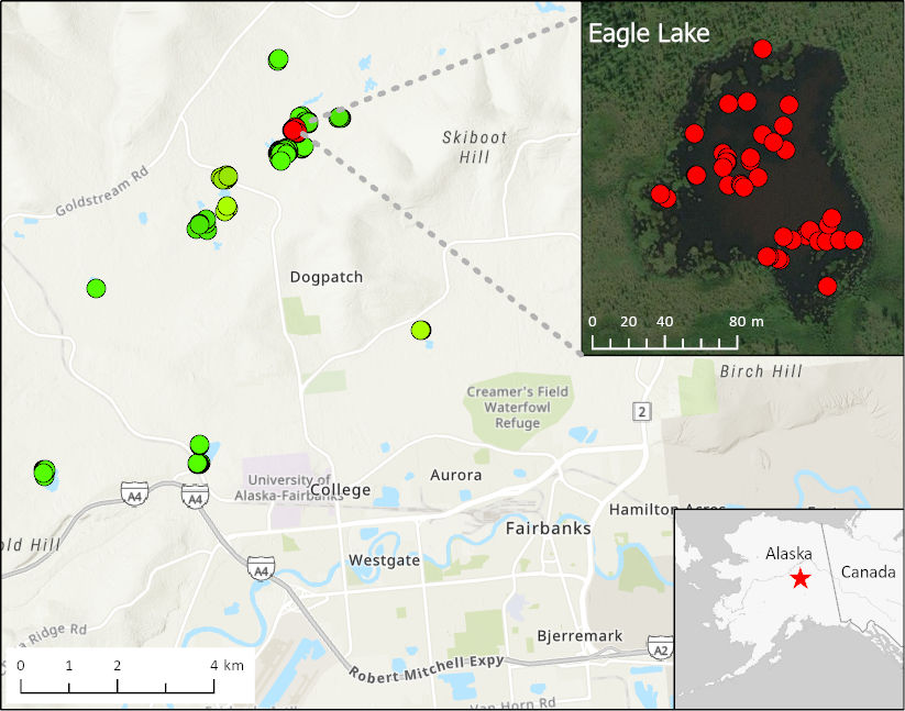
ABoVE: Methane Ebullition Hotspots in Frozen Lakes near Fairbanks, Alaska, Oct 2014 recent views
National Aeronautics and Space Administration —
This dataset includes maps of the locations and number of methane ebullition hotspots in 15 frozen lakes in the southern portion of the Goldstream Valley and the... -
Federal
LBA Regional Land Cover from AVHRR, 1-km, 1992-1993 (Hansen et al.) recent views
National Aeronautics and Space Administration —
This data set is a subset of Hansen et al. (1999), "1 km Global Land Cover Data Set Derived from AVHRR," which was developed at the Laboratory for Global Remote... -
Federal
LBA Regional Vegetation and Soils, 1-Degree (Wilson and Henderson-Sellers) recent views
National Aeronautics and Space Administration —
This data set is a subset of a global vegetation and soils data set by Wilson and Henderson-Sellers (1985a). The subset was created for the study area of the Large... -
Federal
LBA Regional Mean Climatology, 0.5-Deg, 1930-1960, V. 2.1 (Cramer and Leemans) recent views
National Aeronautics and Space Administration —
This data set is a subset of Cramer and Leemans' (2001) global database of mean monthly climatology, which contains monthly averages of mean temperature, temperature... -
Federal
LBA Regional Organic Soil Carbon and Nitrogen Data (Zinke et al.) recent views
National Aeronautics and Space Administration —
The data set contains a subset of a global organic soil carbon and nitrogen data set (Zinke et al. 1986). The subset was created for the study area of the Large Scale... -
Federal
LBA Regional Land Cover from AVHRR, 8-km, 1984 (DeFries et al.) recent views
National Aeronautics and Space Administration —
This data set is a subset of an 8-km global land cover product (DeFries et al. 1998). This subset was created for the study area of the Large Scale Biosphere-... -
Federal
LBA Regional Historical Croplands, 5-min, 1900-1992 (Ramankutty and Foley) recent views
National Aeronautics and Space Administration —
This data set is a subset of a global croplands data set (Ramankutty and Foley 1999a). The subset was created for the study area of the Large Scale Biosphere-... -
Federal
LBA Regional River Discharge Data (Coe and Olejniczak) recent views
National Aeronautics and Space Administration —
This data set is a subset of a global river discharge data set by Coe and Olejniczak (1999). The subset was created for the study area of the Large Scale Biosphere-... -
Federal
ISLSCP II Continuous Fields of Vegetation Cover, 1992-1993 NGDA recent views
National Aeronautics and Space Administration —
The objective of this study was to derive continuous fields of vegetation cover from multi-temporal Advanced Very High Resolution Radiometer (AVHRR) data using all... -
Federal
ISLSCP II IGBP DISCover and SiB Land Cover, 1992-1993 NGDA recent views
National Aeronautics and Space Administration —
This data set describes the geographic distributions of 17 classes of land cover based on the International Geosphere-Biosphere DISCover land cover legend (Loveland... -
Federal
LBA Regional Carbon in Live Vegetation, 0.5-degree (Olson) recent views
National Aeronautics and Space Administration —
This data set is a subset of Olson et al. (1985, 2000) "Major World Ecosystem Complexes Ranked by Carbon in Live Vegetation." This subset was created for the study...

Official websites use .gov
A
.gov website belongs to an official government
organization in the United States.
Secure .gov websites use HTTPS
A
lock (
) or https:// means you’ve safely connected to
the .gov website. Share sensitive information only on official,
secure websites.