
-
Federal
MEaSUREs Gridded Sea Surface Height Anomalies Version 2205
National Aeronautics and Space Administration —
This dataset provides gridded Sea Surface Height Anomalies (SSHA) above a mean sea surface, on a 1/6th degree grid every 5 days. It contains the fully corrected... -
Federal
GRACE-FO Level-2 Monthly Geopotential Spherical Harmonics GFZ Release 6.1 (RL06.1)
National Aeronautics and Space Administration —
FOR EXPERT USE ONLY. This dataset contains estimates of the total month-by-month geopotential of the Earth, derived from the Gravity Recovery and Climate Experiment... -
Federal
SWOT Level 2 Water Mask Pixel Cloud Auxiliary Data Product, Version 1.1
National Aeronautics and Space Administration —
Auxiliary information for pixel cloud product indicating to which water bodies the pixels are assigned in river and lake products. Also includes height-constrained... -
Federal
JPL GRACE and GRACE-FO Mascon Ocean, Ice, and Hydrology Equivalent Water Height Coastal Resolution Improvement (CRI) Filtered Release 06.1 Version 03
National Aeronautics and Space Administration —
This dataset contains gridded monthly global water storage/height anomalies relative to a time-mean, derived from GRACE and GRACE-FO and processed at JPL using the... -
Federal
Sentinel-6A MF Jason-CS L2 P4 Altimeter Low Resolution (LR) STC Reduced Ocean Surface Topography
National Aeronautics and Space Administration —
Provides low resolution (LR) short time critical (STC; 36-hour latency) measurements of sea surface height anomaly (SSHA), Significant Wave Height (SWH), and Wind... -
Federal
HOMAGE Monthly Time series of global average steric height anomalies and ocean heat content estimates from gridded in-situ ocean observations version 01
National Aeronautics and Space Administration —
The [HOMAGE_STERIC_OHC_TIME_SERIES_v01] dataset contains monthly global mean ocean heat content (OHC) anomalies as well as thermosteric, halosteric and total steric... -
Federal
Gridded Altimeter Fields with Enhanced Coastal Coverage
National Aeronautics and Space Administration —
The Gridded Altimeter Fields with Enhanced Coastal Coverage data product contains Sea Surface Height Anomalies (SSHA or SLA) and zonal and meridional geostrophic... -
Federal
ECCO Sea Surface Height - Monthly Mean llc90 Grid (Version 4 Release 4)
National Aeronautics and Space Administration —
This dataset provides monthly-averaged dynamic sea surface height and model sea level anomaly on the native Lat-Lon-Cap 90 (LLC90) model grid from the ECCO Version 4... -
Federal
Sentinel-6A MF Jason-CS L2 P4 Altimeter High Resolution (HR) NRT Ocean Surface Topography
National Aeronautics and Space Administration —
Provides L2 high resolution (HR) near real time (NRT; 3-hour latency) altimetry from the Poseidon-4 SAR altimeter on the Sentinel-6A Michael Freilich spacecraft. It... -
Federal
Sentinel-6A MF Jason-CS L2 P4 Altimeter Low Resolution (LR) STC Ocean Surface Topography
National Aeronautics and Space Administration —
Provides low resolution (LR) short time critical (STC; 36-hour latency) measurements of sea surface height anomaly (SSHA), Significant Wave Height (SWH), and Wind... -
Federal
Sentinel-6A MF Jason-CS L2 P4 Altimeter Low Resolution (LR) NRT Ocean Surface Topography
National Aeronautics and Space Administration —
Provides low resolution (LR) near real time (NRT; 3-hour latency) measurements of sea surface height anomaly (SSHA), Significant Wave Height (SWH), and Wind Speed,... -
Federal
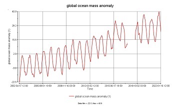
GRACE/GRACE-FO Level-4 Monthly Global Ocean Mass Anomaly version 01 from NASA MEaSUREs HOMaGE project
National Aeronautics and Space Administration —
This data set contains the monthly Global Ocean Mass Anomalies (goma) since 04/2002, as measured by the GRACE and GRACE Follow-On (G/GFO) satellite missions. The data... -
Federal
Sentinel-6A MF Jason-CS L2 Advanced Microwave Radiometer (AMR-C) STC Geophysical Parameters
National Aeronautics and Space Administration —
Provides L2 short time critical (STC; 36-hour latency) geophysical information from the Advanced Microwave Radiometer on the Sentinel-6A Michael Freilich spacecraft... -
Federal
Sentinel-6A MF Jason-CS L2 Advanced Microwave Radiometer (AMR-C) NRT Geophysical Parameters
National Aeronautics and Space Administration —
Provides L2 near real time (NRT; 3-hour latency) geophysical information from the Advanced Microwave Radiometer on the Sentinel-6A Michael Freilich spacecraft... -
Federal
Sentinel-6A MF Jason-CS L2 P4 Altimeter High Resolution (HR) STC Ocean Surface Topography
National Aeronautics and Space Administration —
Provides L2 high resolution (HR) short time critical (STC; 36-hour latency) altimetry from the Poseidon-4 SAR altimeter on the Sentinel-6A Michael Freilich... -
Federal
SWOT Simulated Level-2 Nadir SSH from MITgcm ECCO LLC4320 for Science Version 1
National Aeronautics and Space Administration —
This dataset provides simulated sea surface height (SSH) in a format similar to the future SWOT Level 2 (L2) altimetry data stream from the Poseidon 3C nadir... -
Federal
Sentinel-6A MF Jason-CS L2 P4 Altimeter High Resolution (HR) STC Reduced Ocean Surface Topography
National Aeronautics and Space Administration —
Provides L2 high resolution (HR) short time critical (STC; 36-hour latency) altimetry from the Poseidon-4 SAR altimeter on the Sentinel-6A Michael Freilich... -
Federal
Sentinel-6A MF Jason-CS L2 P4 Altimeter Low Resolution (LR) NRT Reduced Ocean Surface Topography
National Aeronautics and Space Administration —
Provides low resolution (LR) near real time (NRT; 3-hour latency) measurements of sea surface height anomaly (SSHA), Significant Wave Height (SWH), and Wind Speed.... -
Federal
SWOT Level 2 Water Mask Pixel Cloud Data Product, Version 1.1
National Aeronautics and Space Administration —
Point cloud of water mask pixels (“pixel cloud”) with geolocated heights, backscatter, geophysical fields, and flags. Point cloud over tile (approx 64x64 km2); half... -
Federal
Sentinel-6A MF Jason-CS L2 P4 Altimeter High Resolution (HR) NRT Reduced Ocean Surface Topography
National Aeronautics and Space Administration —
Provides L2 high resolution (HR) near real time (NRT; 3-hour latency) altimetry from the Poseidon-4 SAR altimeter on the Sentinel-6A Michael Freilich spacecraft. It...

Official websites use .gov
A
.gov website belongs to an official government
organization in the United States.
Secure .gov websites use HTTPS
A
lock (
) or https:// means you’ve safely connected to
the .gov website. Share sensitive information only on official,
secure websites.