
-
Federal
H10401: NOS Hydrographic Survey , Southwest Texas Coast, Texas, 1991-11-16
National Oceanic and Atmospheric Administration, Department of Commerce —
The National Oceanic and Atmospheric Administration (NOAA) has the statutory mandate to collect hydrographic data in support of nautical chart compilation for safe... -
Federal
NOAA TIFF Image - NF12_PR_1002_bathy_8m.tif - Benthic Habitat Characterization - NOAA Ship Nancy Foster - M-I907-NF-12 (2012), UTM 20N NAD83
National Oceanic and Atmospheric Administration, Department of Commerce —
This image represents a 8 meter resolution bathymetry of a reef shelf/bank and the steep canyons and slopes of the NE Reserve, offshore of Fajardo, Puerto Rico. The... -
Federal
NOAA TIFF Image - 1 m Backscatter Mosaic of Bajo de Cico, Puerto Rico, Project NF-07-06, 2007, UTM 19 NAD83
National Oceanic and Atmospheric Administration, Department of Commerce —
This image represents a 1 meter resolution backscatter mosaic of Bajo de Cico off the coast of western Puerto Rico, collected using a Kongsberg EM 1002 (95 kHz)... -
Federal
NOAA TIFF Image - 3 m Backscatter Mosaic of the south west shore (La Parguera) of Puerto Rico, Project NF-06-03, 2006, UTM 19 WGS84
National Oceanic and Atmospheric Administration, Department of Commerce —
This image represents a 3 meter resolution backscatter mosaic of the south west shore (La Parguera) of Puerto Rico. NOAA's NOS/NCCOS/CCMA Biogeography Team, in... -
Federal
Gulf of Maine - Water Salinity, Temperature and Sigma t (density) data from 1956 to 1980
National Oceanic and Atmospheric Administration, Department of Commerce —
This table contains water salinity, temperature and sigma t (density) data from 1956 to 1980 binned at 10 meter depth intervals (from 300 meters up to 0 meters) for... -
Federal
NOAA TIFF Image - 1 m Backscatter Mosaic of the St. John Shelf, U.S. Virgin Islands, Project NF-10-03, 2010, UTM 20 WGS84
National Oceanic and Atmospheric Administration, Department of Commerce —
This image represents a 1 meter resolution backscatter mosaic of the St. John Shelf, US Virgin Islands. NOAA's NOS/NCCOS/CCMA Biogeography Team, in collaboration with... -
Federal
H10003: NOS Hydrographic Survey , St. Croix, Virgin Islands, 1982-04-14
National Oceanic and Atmospheric Administration, Department of Commerce —
The National Oceanic and Atmospheric Administration (NOAA) has the statutory mandate to collect hydrographic data in support of nautical chart compilation for safe... -
Federal
NOAA Office for Coastal Management Coastal Inundation Digital Elevation Model: Georgia, South
National Oceanic and Atmospheric Administration, Department of Commerce —
These data were created as part of the National Oceanic and Atmospheric Administration Office for Coastal Management's efforts to create an online mapping viewer... -
Federal
CO-OPS station 9751401: LIME TREE BAY, ST CROIX 1-minute Raw Tsunami Water Level Data
National Oceanic and Atmospheric Administration, Department of Commerce —
CO-OPS has been involved with tsunami warning and mitigation since the Coast and Geodetic Survey started the Tsunami Warning System in 1948 to provide warnings to the... -
Federal
Regional Hydrodynamic Model Outputs of the NOAA Chesapeake Bay Operational Forecast System (CBOFS)
National Oceanic and Atmospheric Administration, Department of Commerce —
Oceanographic nowcasts and forecast guidance are scientific predictions about the present and future states of a water body (generally including water levels,... -
Federal
Regional Hydrodynamic Model Outputs of the NOAA Lake Huron Operational Forecast System (LHOFS)
National Oceanic and Atmospheric Administration, Department of Commerce —
The Lake Huron Operational Forecast System (LHOFS) is a NOAA project aimed at providing improved predictions of water levels, currents and water temperatures in Lake... -
Federal
H12115: NOS Hydrographic Survey , Pribilof Canyon, Alaska, 2009-06-18
National Oceanic and Atmospheric Administration, Department of Commerce —
The National Oceanic and Atmospheric Administration (NOAA) has the statutory mandate to collect hydrographic data in support of nautical chart compilation for safe... -
Federal
H10100: NOS Hydrographic Survey , Lake Superior, Minnesota, 1983-08-20
National Oceanic and Atmospheric Administration, Department of Commerce —
The National Oceanic and Atmospheric Administration (NOAA) has the statutory mandate to collect hydrographic data in support of nautical chart compilation for safe... -
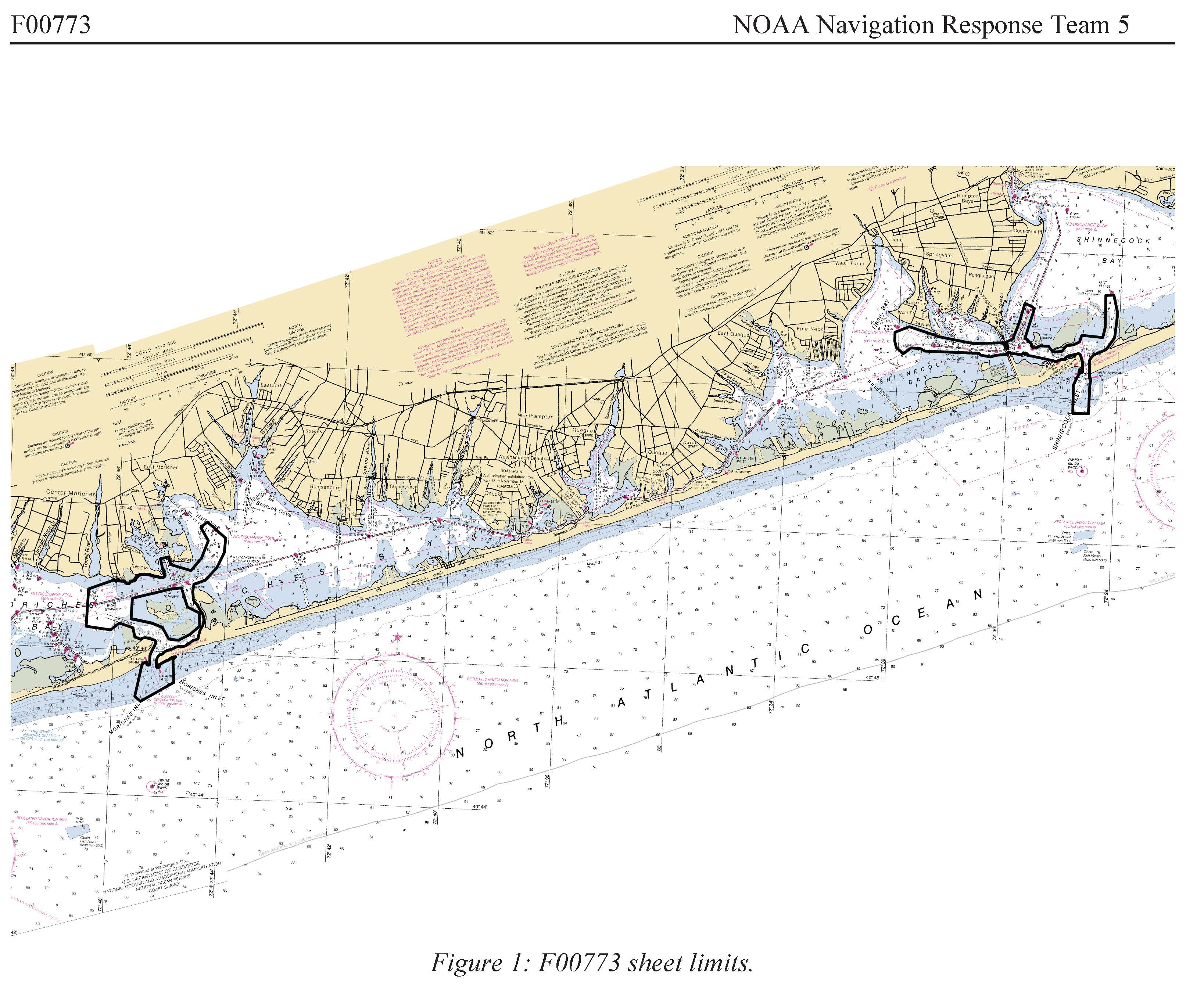
Federal
F00773: NOS Hydrographic Survey , 2019-06-07
National Oceanic and Atmospheric Administration, Department of Commerce —
The National Oceanic and Atmospheric Administration (NOAA) has the statutory mandate to collect hydrographic data in support of nautical chart compilation for safe... -
Federal
Three Saints Bay
National Oceanic and Atmospheric Administration, Department of Commerce —
Timeseries data from 'Three Saints Bay' (noaa_nos_co_ops_twc2047) -
Federal
Northern Carroll Inlet Gps Tide Buoy, AK
National Oceanic and Atmospheric Administration, Department of Commerce —
Timeseries data from 'Northern Carroll Inlet Gps Tide Buoy, AK' (northern-carroll-inlet-gps-ti) -
Federal
Udagak Strait, AK
National Oceanic and Atmospheric Administration, Department of Commerce —
Timeseries data from 'Udagak Strait, AK' (noaa_nos_co_ops_9462637) -
Federal
Tide Station at Charleston Harbor (South Carolina)
National Oceanic and Atmospheric Administration, Department of Commerce —
Timeseries data from 'Tide Station at Charleston Harbor (South Carolina)' (gov_noaa_water_chts1) -
Federal
Dolgoi Harbor, Dolgoi Island, AK
National Oceanic and Atmospheric Administration, Department of Commerce —
Timeseries data from 'Dolgoi Harbor, Dolgoi Island, AK' (noaa_nos_co_ops_9459758) -
Federal
Mining Camp, AK
National Oceanic and Atmospheric Administration, Department of Commerce —
Timeseries data from 'Mining Camp, AK' (noaa_nos_co_ops_9457671)

Official websites use .gov
A
.gov website belongs to an official government
organization in the United States.
Secure .gov websites use HTTPS
A
lock (
) or https:// means you’ve safely connected to
the .gov website. Share sensitive information only on official,
secure websites.
.jpg)