
-
Federal
ESA CCI Ocean Colour Product (CCI ALL-v5.0-DAILY), 0.04166666°, 1997-present
National Oceanic and Atmospheric Administration, Department of Commerce —
Data products generated by the Ocean Colour component of the European Space Agency Climate Change Initiative project. These files are daily composites of merged... -
Federal
NOAA/WDS Paleoclimatology - Amédée Island, New Caledonia, 350 Year Coral Sr/Ca SST Reconstruction
National Oceanic and Atmospheric Administration, Department of Commerce —
This archived Paleoclimatology Study is available from the NOAA National Centers for Environmental Information (NCEI), under the World Data Service (WDS) for... -
Federal
Australian Western Equatorial JGOFS Data: Oceanographic profile temperature, salinity, nutrients, and other measurements collected using bottle and high resolution CTD from the FRANKLIN in the Equatorial Pacific, South Pacific, and other locations from 1990 to 1993 (NCEI Accession 0000569)
National Oceanic and Atmospheric Administration, Department of Commerce —
The OZGOFS research project was a multidisciplinary project comprising 3 research cruises on the R.V. Franklin in October 1990, July 1992 and November 1993. The area... -
Federal
Aqua MODIS Level-3 Global Binned 11µm Nighttime Sea Surface Temperature (NSST) Data, version R2019.0 NGDA
National Aeronautics and Space Administration —
MODIS (or Moderate-Resolution Imaging Spectroradiometer) is a key instrument aboard the Terra (EOS AM) and Aqua (EOS PM) satellites. Terra's orbit around the Earth is... -
Federal
R-Factor for the Island of Lanai
National Oceanic and Atmospheric Administration, Department of Commerce —
The rainfall-runoff erosivity factor (R-Factor) quantifies the effects of raindrop impacts and reflects the amount and rate of runoff associated with the rain. The... -
Federal
AFSC/NMML/CCEP: Food habits of California sea lions in Washington, 1986 - 1999
National Oceanic and Atmospheric Administration, Department of Commerce —
From 1986 to 1999, The National Marine Mammal Laboratories' California Current Ecosystem Program (AFSC/NOAA) collected fecal samples and stomachs of male California... -
Federal
Aqua MODIS Level-3 Global Mapped 11µm Nighttime Sea Surface Temperature (NSST) Data, version R2019.0 NGDA
National Aeronautics and Space Administration —
MODIS (or Moderate-Resolution Imaging Spectroradiometer) is a key instrument aboard the Terra (EOS AM) and Aqua (EOS PM) satellites. Terra's orbit around the Earth is... -
Federal
Temperature, salinity and other parameters from CTDs from NOAA Ship Ronald H. Brown during the 2016 El Niño Rapid Response (ENRR) campaign (NCEI Accession 0162434)
National Oceanic and Atmospheric Administration, Department of Commerce —
During the NOAA El Niño Rapid Response (ENRR) field campaign, 33 CTD's were released from NOAA Ship Ronald H. Brown ship over the period Feb 22-Mar 11 2016. The ship... -
Federal
Chlorophyll-a, Orbview-2 SeaWiFS, R2014.0, 0.1°, Global, 1997-2010 (1 Day Composite) DEPRECATED, Lon0360
National Oceanic and Atmospheric Administration, Department of Commerce —
THIS VERSION IS DEPRECATED. SEE THE NEW R2018.0 VERSION IN erdSW2018chla1day. (Feb 2018) NASA GSFC Ocean Color Web distributes science-quality chlorophyll-a... -
Federal
Exploring the exceptional performance of a deep learning stream temperature model and the value of streamflow data: 6 Model evaluation
Department of the Interior —
This data release component contains evaluation metrics used to assess the predictive performance of each stream temperature model. For further description, see the... -
Federal
COBE-SST2 Sea Surface Temperature and Ice
National Oceanic and Atmospheric Administration, Department of Commerce —
A new sea surface temperature (SST) analysis on a centennial time scale is presented. The dataset starts in 1850 with monthly 1x1 means and is periodically updated.... -
Federal
Water-quality and stream discharge data for estimation of nitrogen loads in the South Platte River, Denver, CO, 2017-2018
Department of the Interior —
The purpose of this data release is to provide the original data, analysis methods, and nitrogen loading models in support of a study of the upper South Platte River... -
Federal
Multibeam collection for EQT190014: Multibeam data collected aboard Fugro Equator from 05-Nov-19 to 20-Nov-19, Capetown, South Africa to Rio de Janeiro, Brazil
National Oceanic and Atmospheric Administration, Department of Commerce —
This data set is part of a larger set of data called the Multibeam Bathymetry Database (MBBDB) where other similar data can be found -
Federal
Aqua MODIS Regional Normalized Difference Vegetation Index Land Reflectance Data, version R2022.0 NGDA
National Aeronautics and Space Administration —
MODIS (or Moderate-Resolution Imaging Spectroradiometer) is a key instrument aboard the Terra (EOS AM) and Aqua (EOS PM) satellites. Terra's orbit around the Earth is... -
Federal
OrbView-2 SeaWiFS Global Binned Particulate Inorganic Carbon (PIC) Data, version R2022.0
National Aeronautics and Space Administration —
The SeaWiFS instrument was launched by Orbital Sciences Corporation on the OrbView-2 (a.k.a. SeaStar) satellite in August 1997, and collected data from September 1997... -
Federal
Land area in coastal Louisiana (1932 to 2016) - land area spatial data - multi-date composites for specific years
Department of the Interior —
Coastal Louisiana wetlands are one of the most critically threatened environments in the United States. These wetlands are in peril because Louisiana currently... -
Federal
Aboveground Net Primary Production Estimates from the Yukon Flats National Wildlife Refuge
Department of the Interior —
This dataset is a single comma-delimited text file (.csv). Data include the name of lakes where samples were obtained, the historical dynamics of that lake, the... -
Federal
CERES Bidirectional Scans NPP FM5 Edition1-CV
National Aeronautics and Space Administration —
CER_BDS_NPP-FM5_Edition1-CV is the Clouds and the Earth's Radiant Energy System (CERES) Bidirectional Scans (BDS) Suomi National Polar-orbiting Partnership (NPP)... -
Federal
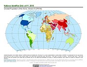
Gridded Population of the World, Version 4 (GPWv4): National Identifier Grid, Revision 11
National Aeronautics and Space Administration —
The Gridded Population of the World, Version 4 (GPWv4): National Identifier Grid, Revision 11 is a raster representation of nation-states in GPWv4 for use in...

Official websites use .gov
A
.gov website belongs to an official government
organization in the United States.
Secure .gov websites use HTTPS
A
lock (
) or https:// means you’ve safely connected to
the .gov website. Share sensitive information only on official,
secure websites.