
-
Federal
Aids To Navigation (ATON) Buoys - Hawaii
National Oceanic and Atmospheric Administration, Department of Commerce —
Displays the location of buoys for the State of Hawaii as recorded on NOAA nautical charts, which are used as aids to navigation (ATONs) to indicate traffic channels,... -
Federal
GHRSST Level 2P Global Sea Surface Temperature v2.0 from the AVHRR on the MetOp-A satellite produced by NAVO (GDS versions 1 and 2)
National Oceanic and Atmospheric Administration, Department of Commerce —
A global Group for High Resolution Sea Surface Temperature (GHRSST) Level 2P dataset containing multi-channel Sea Surface Temperature (SST) retrievals derived in... -
Federal
Timeseries of temperature, salinity, ADCP velocity with ice track, nitrate, fluorescence, turbidity, dissolved oxygen collected from Bering Strait Moorings A2, A3, A4 in Bering Strait from 2022-09-11 to 2023-07-13 (NCEI Accession 0297059)
National Oceanic and Atmospheric Administration, Department of Commerce —
Bering Strait Moorings 2022-2023 This is an archive of data from moorings deployed in Bering Strait from summer 2022 and to summer 2023. Mooring deployments were... -
Federal
Oceanographic data collected during the Deep Water Corals of the Davidson Seamount 2006 expedition aboard R/V WESTERN FLYER in the North Pacific from 2006-01-26 to 2006-02-04 (NCEI Accession 0052881)
National Oceanic and Atmospheric Administration, Department of Commerce —
Building off the successes of an Office of Ocean Exploration (OE) expedition to Davidson Seamount in 2002, this project will focus on deep-water corals. The week-long... -
Federal
Channels - Saipan and Tinian, CNMI
National Oceanic and Atmospheric Administration, Department of Commerce —
Channels around Saipan and Tinian, Commonwealth of the Northern Mariana Islands (CNMI). -
Federal
H08175: NOS Hydrographic Survey , Stand-In Point to Lang Island, Maine, 1955-10-18
National Oceanic and Atmospheric Administration, Department of Commerce —
The National Oceanic and Atmospheric Administration (NOAA) has the statutory mandate to collect hydrographic data in support of nautical chart compilation for safe... -
Federal
TROPICS03 L2B Deep Multispectral INtensity (DMIN) of Tropical cyclones estimator Algorithm V1.0
National Aeronautics and Space Administration —
The "Time-Resolved Observations of Precipitation structure and storm Intensity with a Constellation of Smallsats" (TROPICS) mission has a goal of providing nearly... -
Federal
National Status and Trends, Benthic Surveillance Project Sites, 1984-1992, National Centers for Coastal Ocean Science
National Oceanic and Atmospheric Administration, Department of Commerce —
This data set reports information regarding the nominal sampling locations for the National Status and Trends Benthic Surveillance Project sites. One record is... -
Federal
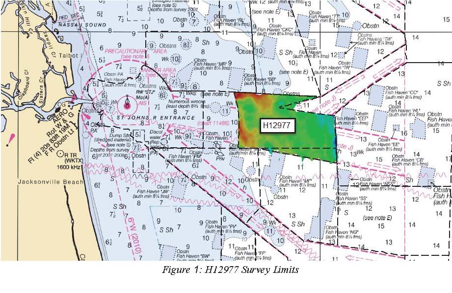
H12977: NOS Hydrographic Survey , 2017-09-05
National Oceanic and Atmospheric Administration, Department of Commerce —
The National Oceanic and Atmospheric Administration (NOAA) has the statutory mandate to collect hydrographic data in support of nautical chart compilation for safe... -
Federal
H13554: NOS Hydrographic Survey , 2021-10-10
National Oceanic and Atmospheric Administration, Department of Commerce —
The National Oceanic and Atmospheric Administration (NOAA) has the statutory mandate to collect hydrographic data in support of nautical chart compilation for safe... -
Federal
AMSR-E/Aqua L2A Global Swath Spatially-Resampled Brightness Temperatures V004
National Aeronautics and Space Administration —
The AMSR-E Level-2A product (AE_L2A) contains daily 50 minute half-orbit swath brightness temperatures for six channels ranging from 6.9 GHz through 89 GHz. Data are... -
State
Named Waterbody Set
State of Connecticut —
Named Waterbody is a 1:24,000-scale, polygon and line feature-based layer that includes all named waterbodies depicted on the U.S. Geological Survey (USGS) 7.5 minute... -
City
SPU DWW Ditches and Culverts
City of Seattle —
Ditches are small to moderate depressions that are created to channel water. Culverts are pipes that are open on both ends that conduct water under a road or railway.... -
State
Hydrography Line
State of Connecticut —
Connecticut Hydrography Set: Connecticut Hydrography Line includes the line features of a layer named Hydrography. Hydrography is a 1:24,000-scale, polygon and line... -
Federal
NOAA Shallow-Water Benthic Habitats: Hawaii: Lanai
National Oceanic and Atmospheric Administration, Department of Commerce —
Benthic habitat maps for the nearshore, shallow (< 30 m) coastal waters of the island of Lanai in the State of Hawaii. NOAA's National Centers for Coastal Ocean... -
Federal
SST, GOES Imager, Day and Night, Western Hemisphere, 2000-2020 (1 Day Composite)
National Oceanic and Atmospheric Administration, Department of Commerce —
NOAA CoastWatch provides SST data from the NOAA Geostationary Operational Environmental Satellites (GOES). Measurements are gathered by the GOES Imager, a multi-... -
Federal
TROPICS06 L1B Orbital Geolocated Native-Resolution Brightness Temperatures V1.0
National Aeronautics and Space Administration —
The "Time-Resolved Observations of Precipitation structure and storm Intensity with a Constellation of Smallsats" (TROPICS) mission has a goal of providing nearly... -
Federal
TROPICS05 L1B Orbital Geolocated Native-Resolution Brightness Temperatures V0.2
National Aeronautics and Space Administration —
The "Time-Resolved Observations of Precipitation structure and storm Intensity with a Constellation of Smallsats" (TROPICS) mission has a goal of providing nearly... -
Federal
Brown pelican at-sea density off California
National Oceanic and Atmospheric Administration, Department of Commerce —
The Office of National Marine Sanctuary Program (ONMS) updates and revises the management plans for each of its 13 sanctuaries. This process, which is open to the... -
Federal
NOAA/WDS Paleoclimatology - Porter - Amacokvik Channel Mackenzie Delta - PCGL - ITRDB CANA504
National Oceanic and Atmospheric Administration, Department of Commerce —
This archived Paleoclimatology Study is available from the NOAA National Centers for Environmental Information (NCEI), under the World Data Service (WDS) for...

Official websites use .gov
A
.gov website belongs to an official government
organization in the United States.
Secure .gov websites use HTTPS
A
lock (
) or https:// means you’ve safely connected to
the .gov website. Share sensitive information only on official,
secure websites.