
-
Federal
Wind, QuikSCAT SeaWinds, 0.125°, Global, Science Quality, 1999-2009, Divergence and Modulus (1 Day), Lon+/-180 recent views
National Oceanic and Atmospheric Administration, Department of Commerce —
Remote Sensing Inc. distributes science quality wind divergence and modulus data from the SeaWinds instrument onboard NASA's QuikSCAT satellite. SeaWinds is a... -
Federal
NRDA-processed CTD data from the OCEAN VERITAS in the Gulf of Mexico, Cruise 7 Leg 1, collected from 2010-07-02 to 2010-07-04, associated with the Deepwater Horizon Oil Spill event (NCEI Accession 0128185) recent views
National Oceanic and Atmospheric Administration, Department of Commerce —
Conductivity Temperature and Depth (CTD) measurements were collected aboard R/V Ocean Veritas 07 to determine physical oceanographic parameters of the water column,... -
Federal
Chlorophyll-a, Aqua MODIS, NPP, 2002-2013, DEPRECATED OLDER VERSION (8 Day Composite) recent views
National Oceanic and Atmospheric Administration, Department of Commerce —
NOAA CoastWatch distributes chlorophyll-a concentration data from NASA's Aqua Spacecraft. Measurements are gathered by the Moderate Resolution Imaging... -
Federal
Chlorophyll-a, Aqua MODIS, NPP, Gulf of Mexico, 2002-2012 (14 Day Composite) recent views
National Oceanic and Atmospheric Administration, Department of Commerce —
NOAA CoastWatch distributes chlorophyll-a concentration data from NASA's Aqua Spacecraft. Measurements are gathered by the Moderate Resolution Imaging... -
Federal
First ISCCP Regional Experiment (FIRE) Atlantic Stratocumulus Transition Experiment (ASTEX) United Kingdom Meteorological Office (UKMO) C-130 Aircraft Data recent views
National Aeronautics and Space Administration —
The First ISCCP Regional Experiments have been designed to improve data products and cloud/radiation parameterizations used in general circulation models (GCMs).... -
Federal
First ISCCP Regional Experiment (FIRE) Atlantic Stratocumulus Transition Experiment (ASTEX) PSU Malcolm Baldridge Wind Profiler Data recent views
National Aeronautics and Space Administration —
The First ISCCP Regional Experiments have been designed to improve data products and cloud/radiation parameterizations used in general circulation models (GCMs).... -
Federal
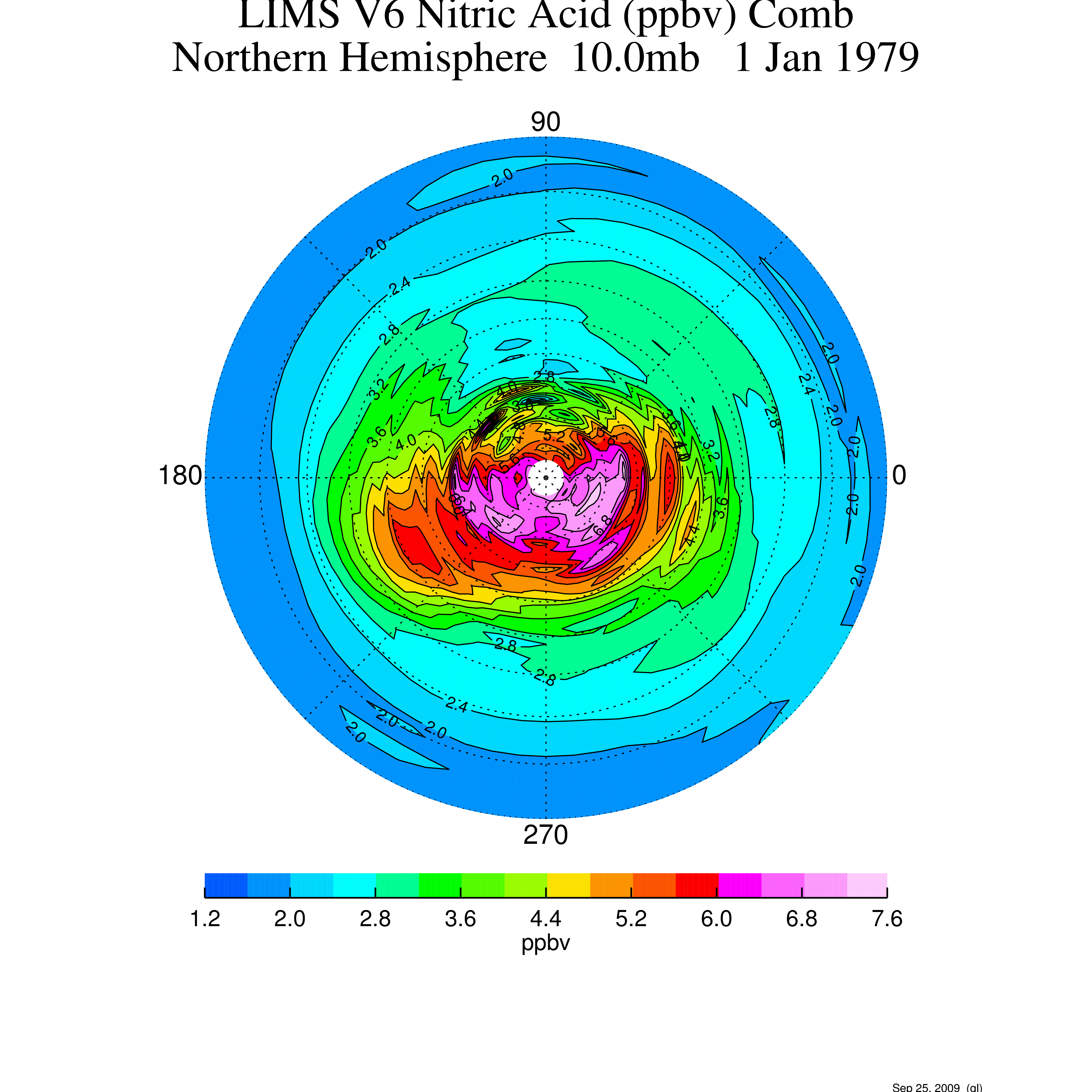
LIMS/Nimbus-7 Level 3 Daily 2 deg Latitude Zonal Fourier Coefficients of O3, NO2, H2O, HNO3, Geopotential Height, and Temperature V006 (LIMSN7L3) at GES DISC recent views
National Aeronautics and Space Administration —
The Limb Infrared Monitor of the Stratosphere (LIMS) version 6 Level-3 data product consists of daily, 2 degree zonal Fourier coefficients, of vertical profiles of... -
Federal
Navy Operational Global Atmospheric Prediction System (NOGAPS), 1 degree, 2012-2013, 500 hPa Height recent views
National Oceanic and Atmospheric Administration, Department of Commerce —
The Navy Operational Global Atmospheric Prediction System (NOGAPS) is a global numerical weather prediction computer model run by the United States Navy's Fleet... -
Federal
Chlorophyll a, North Pacific, NOAA VIIRS, 750m resolution, 2015-present (3 Day Composite) recent views
National Oceanic and Atmospheric Administration, Department of Commerce —
NOAA CoastWatch distributes L3 level chlorophyll a concentration data derived from measurements take by the VIIRS sensor (Visible Infrared Imaging Radiometer Suite)... -
Federal
Fluorescence Line Height, Aqua MODIS, NPP, Gulf of Mexico, 2002-2012 (14 Day Composite) recent views
National Oceanic and Atmospheric Administration, Department of Commerce —
MODIS measures chlorophyll fluorescence, which gives insight into the physiology of phytoplankton in the ocean. When phytoplankton are under stress, the rate at which... -
Federal
Ice Coverage, Aqua AMSR-E, Near Real Time, Global, 2004-2011 (1 Day Composite) recent views
National Oceanic and Atmospheric Administration, Department of Commerce —
Ice Coverage is measured by the Advanced Microwave Scanning Radiometer for the Earth Observing System (AMSR-E) onboard NASA's Aqua spacecraft. -
Federal
Chlorophyll-a, Aqua MODIS, NPP, East US, 2002-2012 (Monthly Composite), Lon0360 recent views
National Oceanic and Atmospheric Administration, Department of Commerce —
NOAA CoastWatch distributes chlorophyll-a concentration data from NASA's Aqua Spacecraft. Measurements are gathered by the Moderate Resolution Imaging... -
Federal
SST, POES AVHRR, GAC, Global, Day and Night, 2006-2016 (8 Day Composite) recent views
National Oceanic and Atmospheric Administration, Department of Commerce —
NOAA CoastWatch provides sea surface temperature (SST) products derived from NOAA's Polar Operational Environmental Satellites (POES). This data provides global area... -
Federal
SST, POES AVHRR, LAC, Alaska, Day and Night, 2006-2008 (3 Day Composite), Lon+/-180 recent views
National Oceanic and Atmospheric Administration, Department of Commerce —
NOAA CoastWatch provides sea surface temperature (SST) products derived from NOAA's Polar Operational Environmental Satellites (POES). This data is provided at high... -
Federal
Remote Sensing Reflectance at 667 nm, Aqua MODIS, NPP, East US, 2002-2012 (3 Day Composite), Lon0360 recent views
National Oceanic and Atmospheric Administration, Department of Commerce —
MODIS measures the remote sensing reflectance (Rrs) at 667nm. This can be used to view very high concentrations of phytoplankton in the very surface of the water. -
Federal
SST, GOES Imager, Day and Night, Western Hemisphere, 2000-2020 (3 Day Composite), Lon+/-180 recent views
National Oceanic and Atmospheric Administration, Department of Commerce —
NOAA CoastWatch provides SST data from the NOAA Geostationary Operational Environmental Satellites (GOES). Measurements are gathered by the GOES Imager, a multi-... -
Federal
Fluorescence Line Height, Aqua MODIS, NPP, Gulf of Mexico, 2002-2012 (Monthly Composite) recent views
National Oceanic and Atmospheric Administration, Department of Commerce —
MODIS measures chlorophyll fluorescence, which gives insight into the physiology of phytoplankton in the ocean. When phytoplankton are under stress, the rate at which... -
Federal
CTD, Oxygen, and others collected from R/V Atlantic/ALVIN in the Gulf of Mexico from 2014-03-31 to 2014-04-21 (NCEI Accession 0162834) recent views
National Oceanic and Atmospheric Administration, Department of Commerce —
Hydrographic data were collected during cruise AT2613 using a CTD-rosette system aboard R/V Atlantis. We characterized the physical and chemical properties in the... -
Federal
Physical trajectory profile data from glider angus deployed by Skidaway Institute of Oceanography in the North Atlantic Ocean from 2019-11-11 to 2019-11-28 (NCEI Accession 0209352) recent views
National Oceanic and Atmospheric Administration, Department of Commerce —
SKIO Angus Glider deployment in the North Atlantic Ocean. The National Centers for Environmental Information (NCEI) received the data in this archival package from... -
Federal
SST, Aqua MODIS, NPP, Gulf of Mexico, Nighttime (11 microns), 2002-2012 (3 Day Composite) recent views
National Oceanic and Atmospheric Administration, Department of Commerce —
NOAA CoastWatch provides SST data from NASA's Aqua Spacecraft. Measurements are gathered by the Moderate Resolution Imaging Spectroradiometer (MODIS) carried aboard...

Official websites use .gov
A
.gov website belongs to an official government
organization in the United States.
Secure .gov websites use HTTPS
A
lock (
) or https:// means you’ve safely connected to
the .gov website. Share sensitive information only on official,
secure websites.