
-
Federal
Optical Thickness Cross-Calib. (FIFE) recent views
National Aeronautics and Space Administration —
Cross referenced calibration optical thickness data from C-130 and KSU staff -
Federal
Gemma Helicopter Data (FIFE) recent views
National Aeronautics and Space Administration —
Spectral reflected radiances measured with Russian GEMMA spectrometer from a helicopter -
Federal
Satellite Landsat TM Extr. Data (FIFE) recent views
National Aeronautics and Space Administration —
Site reflectances extracted from Landsat TM imagery over FIFE study area -
Federal
Bowen Ratio Surface Flux: USGS (FIFE) recent views
National Aeronautics and Space Administration —
Surface flux measurements by Bowen Ratio technique during FIFE -
Federal
Bowen Ratio Surface Flux: GSFC (FIFE) recent views
National Aeronautics and Space Administration —
Surface flux measurements by Bowen Ratio technique during FIFE -
Federal
Soil Impedance Data (FIFE) recent views
National Aeronautics and Space Administration —
Soil impedance & temperature measured with Radio Frequency Soil Moisture Probe -
Federal
Radiant Temp. Helicopter Data (FIFE) recent views
National Aeronautics and Space Administration —
Temperature data from Everest IR thermometer mounted on the helicopter -
Federal
Soil Reflectance Data (FIFE) recent views
National Aeronautics and Space Administration —
Spectral reflectance of soils, Atlas of Soil Reflectance Properties (Stoner '80) -
Federal
Soil Moisture Neutron Probe Data (FIFE) recent views
National Aeronautics and Space Administration —
Soil moisture data collected using a neutron probe 200cm in length -
Federal
BOREAS HYD-04 Areal Snow Course Survey Data recent views
National Aeronautics and Space Administration —
Contains the areal snow survey data collected by HYD-04. The flight line numbers that are included correspond to the flight lines from HYD-06 measurements. -
Federal
BOREAS Saskatchewan Forest Fire Control Centre Surface Meteorological Data recent views
National Aeronautics and Space Administration —
Contains 1994 and 1995 hourly data from various forestry meteorology stations. -
Federal
Aircraft Flux-Detrended: NRCC (FIFE) recent views
National Aeronautics and Space Administration —
Detrended boundary layer fluxes recorded on aircraft flights over the Konza -
Federal
BOREAS TF-03 NSA-OBS Tower Flux, Meteorological, and Soil Temperature Data recent views
National Aeronautics and Space Administration —
The flux and ancillary data collected at the NSA-OBS tower flux site by the TF-03 group. -
Federal
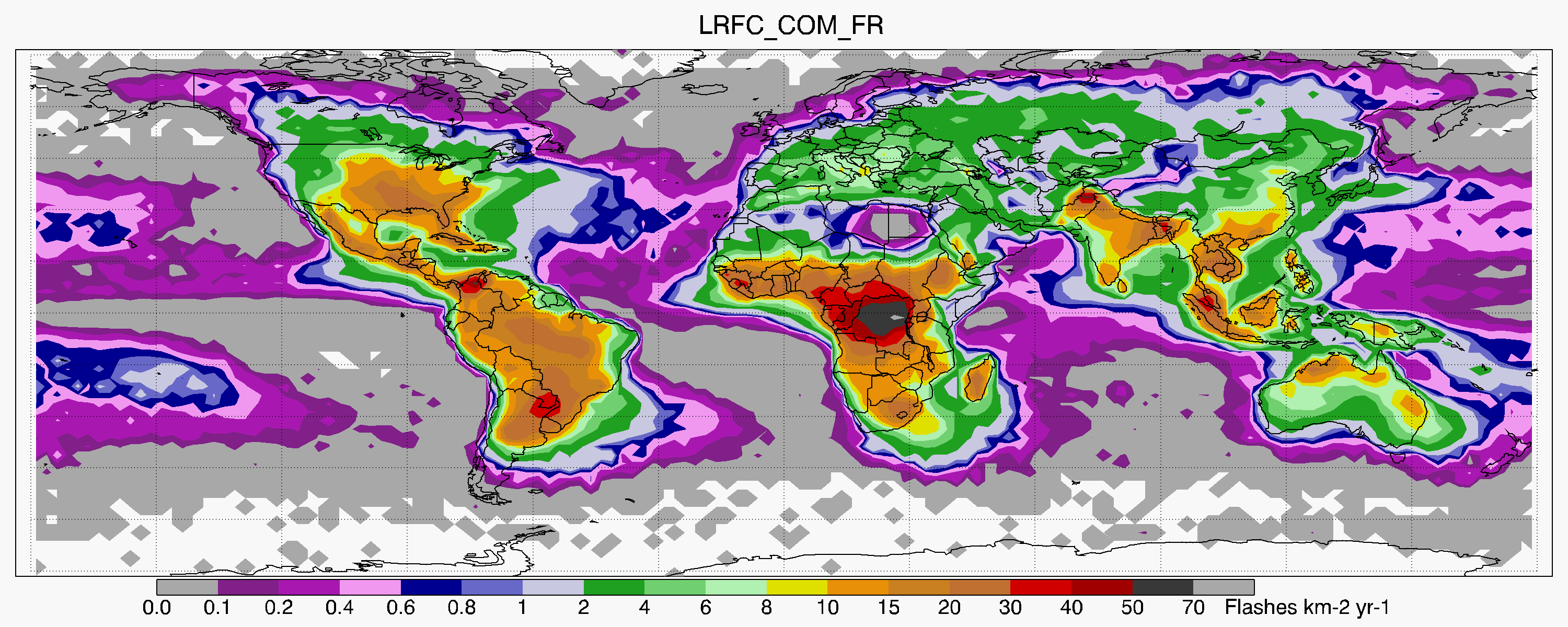
LIS/OTD 2.5 Degree Low Resolution Full Climatology (LRFC) V2.3.2015 recent views
National Aeronautics and Space Administration —
The LIS/OTD 2.5 Degree Low Resolution Full Climatology (LRFC) contains a variety of gridded climatologies of total lightning flash rates obtained from two lightning... -
Federal
Aquatic Health and Climate Change: Long-term Monitoring - Monitoring Sites and USGS Stations recent views
Department of the Interior —
This reference was created to house geospatial data related to Aquatic Health and Climate Change: Long-term Monitoring starting in 2021. This project is the... -
Federal
Bowen Ratio Surface Flux: Smith (FIFE) recent views
National Aeronautics and Space Administration —
Retrieval of surface fluxes from a combination of satellite & surface platforms -
Federal
BOREAS Landsat TM Level-3a Imagery: Scaled At-Sensor Radiance in BSQ Format recent views
National Aeronautics and Space Administration —
For BOREAS, the level-3A Landsat TM data, along with the other remotely sensed images, were collected in order to provide spatially extensive information over the... -
Federal
Vegetation Species Reference (FIFE) recent views
National Aeronautics and Space Administration —
LTER species names, codes, types, and other reference information -
Federal
15 Minute Stream Flow Data: USGS (FIFE) recent views
National Aeronautics and Space Administration —
USGS 15 minute stream flow data for Kings Creek on the Konza Prairie -
Federal
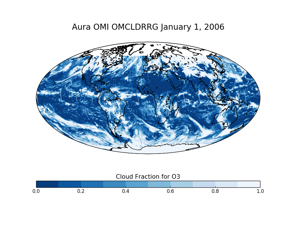
OMI/Aura Effective Cloud Pressure and Fraction (Raman Scattering) Daily L2 Global Gridded 0.25 degree x 0.25 degree V3 (OMCLDRRG) at GES DISC recent views
National Aeronautics and Space Administration —
This Level-2G daily global gridded product OMCLDRRG is based on the pixel level OMI Level-2 CLDRR product OMCLDRR. This level-2G global cloud product (OMCLDRRG)...

Official websites use .gov
A
.gov website belongs to an official government
organization in the United States.
Secure .gov websites use HTTPS
A
lock (
) or https:// means you’ve safely connected to
the .gov website. Share sensitive information only on official,
secure websites.