
-
Federal
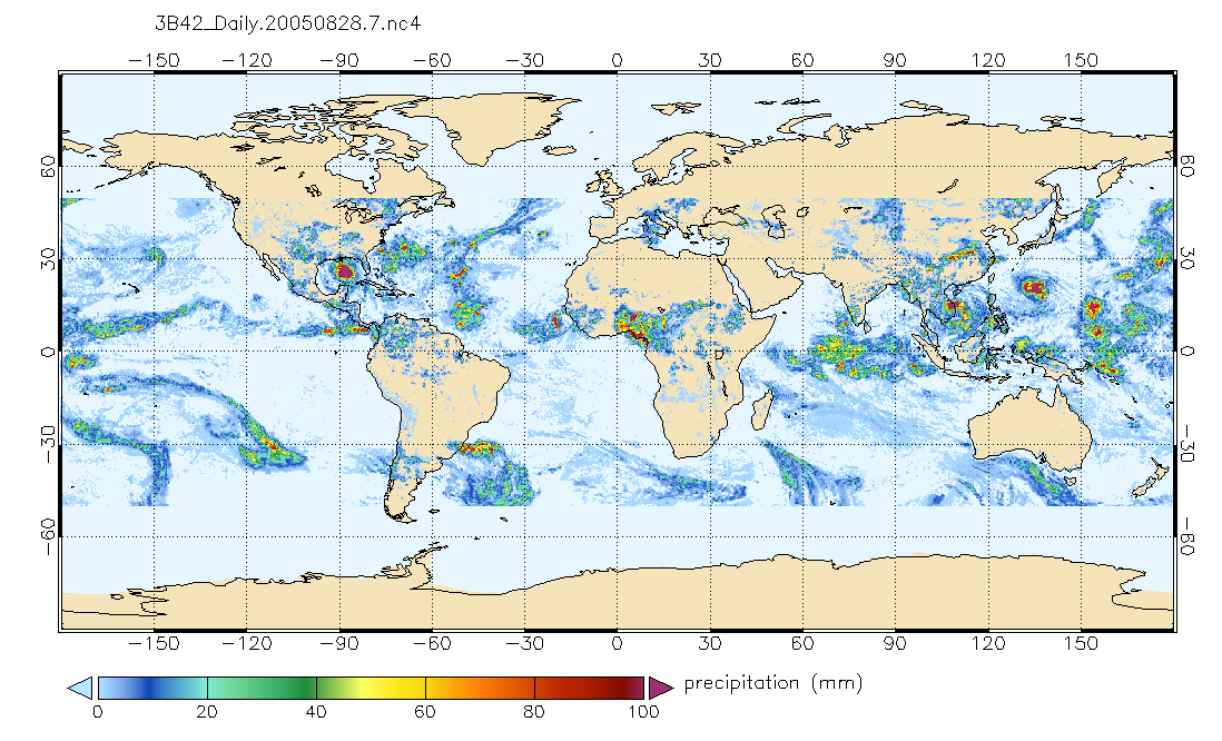
TRMM (TMPA) Precipitation L3 1 day 0.25 degree x 0.25 degree V7 (TRMM_3B42_Daily) at GES DISC recent views
National Aeronautics and Space Administration —
TMPA (3B42_Daily) dataset have been discontinued as of Dec. 31, 2019, and users are strongly encouraged to shift to the successor IMERG dataset (doi:... -
Federal
Airborne Gravity Data - Gravity for the Redefinition of the American Vertical Datum (GRAV-D) NGDA recent views
National Oceanic and Atmospheric Administration, Department of Commerce —
Gravity for the Re-definition of the American Vertical Datum (GRAV-D) is a project initiated by NOAA's National Geodetic Survey to collect and monitor gravity data... -
Federal
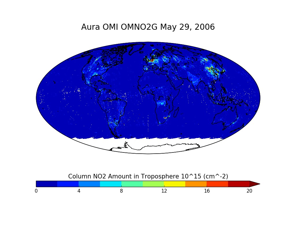
OMI/Aura NO2 Total and Tropospheric Column Daily L2 Global Gridded 0.25 degree x 0.25 degree V3 (OMNO2G) at GES DISC recent views
National Aeronautics and Space Administration —
This Level-2G daily global gridded product OMNO2G is based on the pixel level OMI Level-2 NO2 product OMNO2. OMNO2G data product is a special Level-2 Gridded Product... -
Federal
Annual Summary of Artificial Light At Night from VIIRS/S-NPP at CONUS County and Census Tract V1 (ALAN_VIIRS_CONUS) at GES DISC recent views
National Aeronautics and Space Administration —
This product provides detailed information about the satellite-based data on artificial light at night (ALAN). The Suomi National Polar-orbiting Partnership (S-NPP)... -
Federal
GPM IMERG Late Precipitation L3 Half Hourly 0.1 degree x 0.1 degree V06 (GPM_3IMERGHHL) at GES DISC recent views
National Aeronautics and Space Administration —
The Integrated Multi-satellitE Retrievals for GPM (IMERG) is the unified U.S. algorithm that provides the multi-satellite precipitation product for the U.S. GPM team.... -
Federal
Integrated Global Radiosonde Archive (IGRA), Version 2 recent views
National Oceanic and Atmospheric Administration, Department of Commerce —
Integrated Global Radiosonde Archive (IGRA) Version 2 consists of quality-controlled radiosonde observations of temperature, humidity, and wind at stations across all... -
Federal
NOAA Profiler Network (NPN) Vertical Wind Profile Data recent views
National Oceanic and Atmospheric Administration, Department of Commerce —
The NOAA Profiler Network (NPN) radars provide vertical profiles of horizontal wind speed and direction from near the surface to above the tropopause. The system also... -
Federal
GPCP Precipitation Level 3 Monthly 0.5-Degree V3.2 (GPCPMON) at GES DISC recent views
National Aeronautics and Space Administration —
Version 3.2 is the current version. Older versions have been superseded by Version 3.2. The Global Precipitation Climatology Project (GPCP) is the precipitation... -
Federal
Daymet: Daily Surface Weather Data on a 1-km Grid for North America, Version 4 R1 recent views
National Aeronautics and Space Administration —
This dataset provides Daymet Version 4 R1 data as gridded estimates of daily weather parameters for North America, Hawaii, and Puerto Rico. Daymet variables include... -
Federal
ISLSCP II EDGAR 3 Gridded Greenhouse and Ozone Precursor Gas Emissions recent views
National Aeronautics and Space Administration —
The EDGAR (Emission Database for Global Atmospheric Research) database project is a comprehensive task carried out jointly by the National Institute for Public Health... -
Federal
Global Summary of the Year (GSOY), Version 1 recent views
National Oceanic and Atmospheric Administration, Department of Commerce —
This Global Summaries dataset, known as GSOY for Yearly, contains a yearly resolution of meteorological elements from 1763 to present with updates applied weekly. The... -
Federal
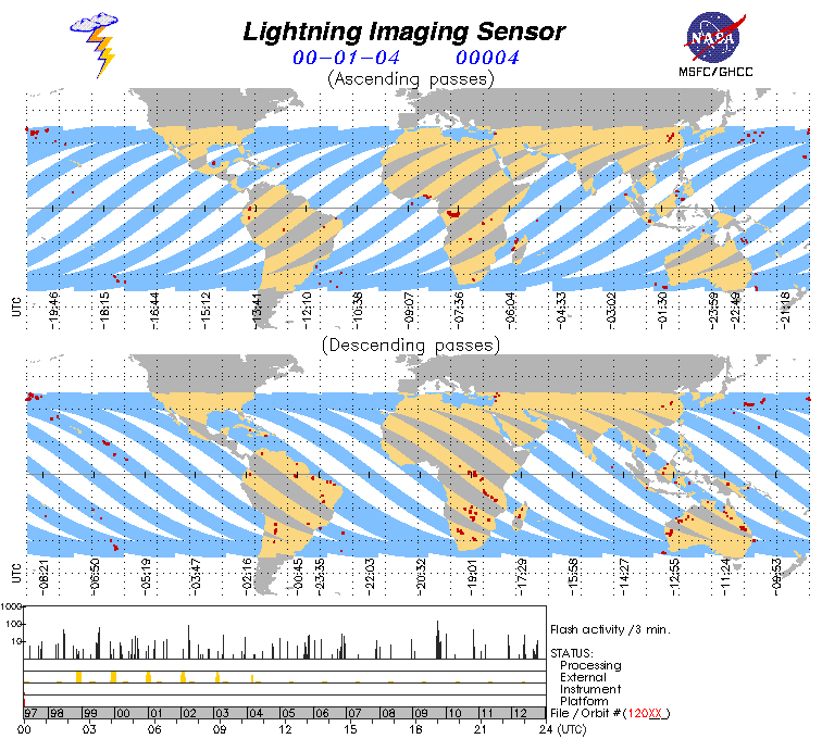
Lightning Imaging Sensor (LIS) on TRMM Science Data V4 recent views
National Aeronautics and Space Administration —
The Lightning Imaging Sensor (LIS) Science Data was collected by the LIS instrument on the Tropical Rainfall Measuring Mission (TRMM) satellite used to detect the... -
Federal
NLDAS Noah Land Surface Model L4 Monthly 0.125 x 0.125 degree V2.0 (NLDAS_NOAH0125_M) at GES DISC recent views
National Aeronautics and Space Administration —
This data set contains fifty-two fields simulated from the Noah land-surface model (LSM) for Phase 2 of the North American Land Data Assimilation System (NLDAS-2).... -
Federal
NOAA GOES-R Series Advanced Baseline Imager (ABI) Level 2 Cloud Cover Layers (CCL) recent views
National Oceanic and Atmospheric Administration, Department of Commerce —
The GOES-R Advanced Baseline Imager (ABI) Cloud Cover Layers (CCL) product contains estimates of cloud fraction between predefined atmospheric levels, as well as, the... -
Federal
Global Historical Climatology Network - Monthly (GHCN-M), Version 2 recent views
National Oceanic and Atmospheric Administration, Department of Commerce —
Please note, the temperature portion of this dataset has been superseded by a newer version. Users should not use this version except in rare cases (e.g., when... -
Federal
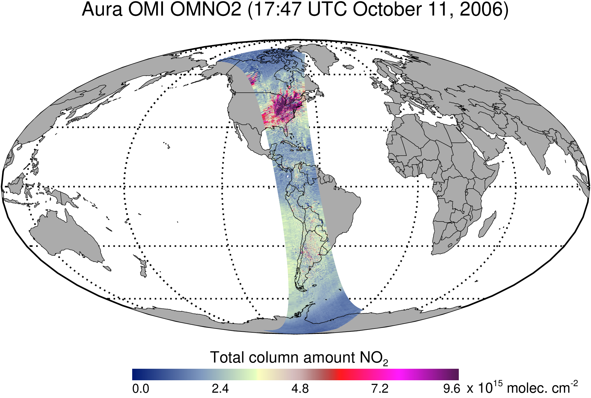
OMI/Aura Nitrogen Dioxide (NO2) Total and Tropospheric Column 1-orbit L2 Swath 13x24 km V003 (OMNO2) at GES DISC recent views
National Aeronautics and Space Administration —
The Version 4.0 Aura Ozone Monitoring Instrument (OMI) Nitrogen Dioxide (NO2) Standard Product (OMNO2) is now available from the NASA Goddard Earth Sciences Data and... -
Federal
CALIPSO Lidar Level 1B profile data, V4-10 recent views
National Aeronautics and Space Administration —
CAL_LID_L1-Standard-V4-10 is the Cloud-Aerosol Lidar and Infrared Pathfinder Satellite Observation (CALIPSO) Lidar Level 1B profile data, Version 4-10 data product.... -
Federal
Regional Snowfall Index (RSI) recent views
National Oceanic and Atmospheric Administration, Department of Commerce —
The Regional Snowfall Index (RSI) is an index of significant snowstorms that impact the eastern two thirds of the U.S. The RSI ranks snowstorm impacts on a scale from... -
Federal
MERRA-2 inst6_3d_ana_Nv: 3d,6-Hourly,Instantaneous,Model-Level,Analysis,Analyzed Meteorological Fields 0.625 x 0.5 degree V5.12.4 (M2I6NVANA) at GES DISC recent views
National Aeronautics and Space Administration —
M2I6NVANA (or inst6_3d_ana_Nv) is an instantaneous 3-dimensional 6-hourly data collection in Modern-Era Retrospective analysis for Research and Applications version 2... -
Federal
NCEP North American Regional Reanalysis (NARR), for 1979 to Present recent views
National Oceanic and Atmospheric Administration, Department of Commerce —
The North America Regional Reanalysis (NARR) Project is a reanalysis of historical observations using a 32-km version of the National Centers for Environmental...

Official websites use .gov
A
.gov website belongs to an official government
organization in the United States.
Secure .gov websites use HTTPS
A
lock (
) or https:// means you’ve safely connected to
the .gov website. Share sensitive information only on official,
secure websites.