

172 datasets found for "Superfund"
-
Federal
FLIR camera thermal imagery for stream sites at the Hemphill Road TCE NPL Superfund Site near Gastonia, North Carolina
Department of the Interior —
The data on this page contain .pdf files of thermal images collected at 10 stream sites nearby study area, showing stream surface and bank seepage temperature readings. -
Federal
Volatile organic compound, polychlorinated biphenyl, and biogeochemical data from passive samplers and laboratory experiments for wetland bioremediation study, Standard Chlorine of Delaware, Inc. Superfund Site, New Castle County, Delaware, 2019–2021
Department of the Interior —
This metadata record contains 15 tables with results from field and laboratory tests used to assess bioremediation in wetland areas at the Standard Chlorine of... -
Federal
Groundwater-level altitudes and volatile and semi-volatile organic compound concentrations at the Petro-Chemical Systems, Inc. (Turtle Bayou) Superfund site, Liberty County, Texas, 2023
Department of the Interior —
In 2023, the U.S. Geological Survey, in cooperation with the U.S. Environmental Protection Agency, collected groundwater-level altitude and water-quality data from... -
Federal
NPL Superfund Operable Unit Boundaries (EPA)
U.S. Environmental Protection Agency —
This GIS dataset contains polygons depicting U.S. EPA Superfund Operable Unit boundaries. The operable unit (OU) polygons represent an individual OU’s perimeters,... -
Federal
Onda Verde Parcels, CRMS, 2020, NDEP
U.S. Environmental Protection Agency —
This feature class contains parcel boundaries and their environmental covenant status within the Onda Verde Subdivision in Churchill County, Nevada. An environmental... -
Federal
Geochemical data for groundwater and surface water from the Waste Rock Dam area, Sulphur Bank Mercury Mine, Lake County, California
Department of the Interior —
The Sulphur Bank Mercury Mine in Lake County, California, was the site of historical mercury mining from 1880s through 1973.Since 1990, the mine area has been a... -
Federal
NOAA's Coastal Protection and Restoration Division: Watershed Database and Mapping Projects
National Oceanic and Atmospheric Administration, Department of Commerce —
Protection and restoration of coastal watersheds requires the synthesis of complex environmental issues. Contaminated site remediation, dredging and disposal of... -
Federal
Carson River Estates Soil Samples, CRMS, 2013, NDEP
U.S. Environmental Protection Agency —
This feature class is converted from GPS coordinates obtained using a GPSmap 60CSx unit from Garmin in the field by AEI Consultants. The attribute information is... -
Federal
Groundwater-Level Elevations and Concentrations of Selected Water-Quality Properties at the Many Diversified Interests, Inc. Superfund Site, Houston, Texas, September 2022
Department of the Interior —
In September 2022, the U.S. Geological Survey, in cooperation with the U.S. Environmental Protection Agency, collected groundwater-level elevation data and water-... -
Federal
Continued Geophysical Logging in the vicinity of the GMH Electronics Superfund Site near Roxboro North Carolina
Department of the Interior —
The collection of borehole geophysical logs and images and continuous water-level data was conducted by the U.S. Geological Survey South Atlantic Water Science Center... -
Federal
OLEM Center for Program Analysis Site Analysis Data
U.S. Environmental Protection Agency —
This asset includes environmental justice-related analyses of population located within a mile of Superfund and RCRA Corrective Action sites. It characterizes... -
Federal
XRF Demonstration of Method Applicability Results, Six Mile Canyon, 2017, ICF and EPA
U.S. Environmental Protection Agency —
This dataset contains final results for the XRF Demonstration of Method Applicability (DMA) conducted by the United States Environmental Protection Agency’s (EPA’s)... -
Federal
Superfund Training/Tech Transfer
U.S. Environmental Protection Agency —
This asset includes a collection of information resources, training, and other media related to hazardous waste site cleanup and characterization. A major part of... -
Federal
Optical and acoustic televiewer image logs for selected wells at the Cristex Drum National Priorities List Superfund Site near Oxford, North Carolina
Department of the Interior —
The data within this page contain .csv files with caliper, optical, acoustic, and tadpole plots of structure measurements. -
Federal
Borehole, Surface, and Water-Borne Geophysical Surveys at the Callahan Mine Superfund Site in Brooksville, Maine: October 2016 to July 2018
Department of the Interior —
From October 2016 to July 2018, the U.S. Geological Survey, in cooperation with the U.S. Army Corps of Engineers and Maine Department of Transportation, collected... -
Federal
Electron microprobe analyses of sphalerite and hemimorphite from mine wastes from the Tar Creek Superfund Site, Tri-State Mining District, Oklahoma, U.S.A.
Department of the Interior —
Electron microprobe analyses of sphalerite (ZnS) and hemimorphite (Zn4Si2O7(OH)2·H2O) from sampled historical waste piles were conducted with a specific focus on... -
Federal
Cleanups In My Community (CIMC) - Base Realignment and Closure (BRAC) Superfund Sites, National Layer
U.S. Environmental Protection Agency —
This data layer provides access to Base Realignment and Closure (BRAC) Superfund Sites as part of the CIMC web service. EPA works with DoD to facilitate the reuse and... -
Federal
NPL Superfund Site Feature Areas (EPA)
U.S. Environmental Protection Agency —
This GIS dataset contains polygons depicting U.S. EPA Superfund features. This dataset is reserved for important Superfund site features that are best captured as... -
Federal
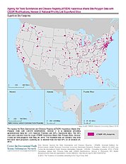
ATSDR Hazardous Waste Site Polygon Data with CIESIN Modifications, Version 2
National Aeronautics and Space Administration —
The Agency for Toxic Substances and Disease Registry (ATSDR) Hazardous Waste Site Polygon Data with CIESIN Modifications, Version 2 is a database providing... -
Federal
Cleanups In My Community (CIMC) - Superfund National Priority List (NPL) Sites, National Layer
U.S. Environmental Protection Agency —
This data layer provides access to Superfund National Priority List Sites as part of the CIMC web service. Superfund is a program administered by the EPA to locate,...
172 datasets found for "Superfund"