
-
Federal
NOAA/WDS Paleoclimatology - Minicoy Island, Lakshadweep, Arabian Sea, 1980-2013 CE, Porites lutea Coral d11B, Sr/Ca, Li/Ca, Mg/Ca, pK*B and pH Data
National Oceanic and Atmospheric Administration, Department of Commerce —
This archived Paleoclimatology Study is available from the NOAA National Centers for Environmental Information (NCEI), under the World Data Service (WDS) for... -
Federal
NOAA/WDS Paleoclimatology - Sea surface temperature and Atlantic Meridional Overturning Circulation of the last 21,000 years
National Oceanic and Atmospheric Administration, Department of Commerce —
This archived Paleoclimatology Study is available from the NOAA National Centers for Environmental Information (NCEI), under the World Data Service (WDS) for... -
Federal
N01 Accelerometer - Waves
National Oceanic and Atmospheric Administration, Department of Commerce —
Ocean observation data from the Northeastern Regional Association of Coastal & Ocean Observing Systems (NERACOOS). The NERACOOS region includes the northeast... -
Federal
EnviroAtlas - Durham, NC - Domestic Water Use per Day by U.S. Census Block Group
U.S. Environmental Protection Agency —
As included in this EnviroAtlas dataset, the community domestic water use was calculated using locally available water use data per capita in gallons of water per day... -
Federal
A01 Directional Waves
National Oceanic and Atmospheric Administration, Department of Commerce —
Ocean observation data from the Northeastern Regional Association of Coastal & Ocean Observing Systems (NERACOOS). The NERACOOS region includes the northeast... -
Federal
TIGER/Line Shapefile, Current, County, Scotland County, NC, Address Range-Feature
U.S. Census Bureau, Department of Commerce —
The TIGER/Line shapefiles and related database files (.dbf) are an extract of selected geographic and cartographic information from the U.S. Census Bureau's Master... -
Federal
D00255: NOS Hydrographic Survey , 2018-09-20
National Oceanic and Atmospheric Administration, Department of Commerce —
The National Oceanic and Atmospheric Administration (NOAA) has the statutory mandate to collect hydrographic data in support of nautical chart compilation for safe... -
Federal
Chemical, physical, profile and other oceanographic data collected aboard the GYRE in the Gulf of Mexico from 2010-09-25 to 2010-09-28 in response to the Deepwater Horizon Oil Spill event (NCEI Accession 0074905)
National Oceanic and Atmospheric Administration, Department of Commerce —
Chemical, physical, profile, imagery, laboratory analysis and sediment analysis oceanographic data were collected aboard the GYRE in the Gulf of Mexico from... -
Federal
0.8 meter backscatter JPEG image (with world file) of the nearshore seafloor off of Whalebone, NC (mosaic7.jpg, UTM Zone 18N, WGS84)
Department of the Interior —
The northeastern North Carolina coastal system, from False Cape, Virginia, to Cape Lookout, North Carolina, has been studied by a cooperative research program that... -
Federal
JPEG images of chirp seismic data from inner shelf U.S. Geological Survey research cruise 2002-013-FA collected by the U.S. Geological Survey
Department of the Interior —
The northeastern North Carolina coastal system, from False Cape, Virginia, to Cape Lookout, North Carolina, has been studied by a cooperative research program that... -
Federal
EnviroAtlas Green Space Proximity Gradient Web Service
U.S. Environmental Protection Agency —
This EnviroAtlas web service supports research and online mapping activities related to EnviroAtlas (https://www.epa.gov/enviroatlas). In any given 1-square meter... -
Federal
Transgressive Contours--Pigeon Point to Monterey, California
Department of the Interior —
This part of DS 781 presents data for the transgressive contours for the depth-to-transition map of the Pigeon Point to Monterey, California, map region. The vector... -
Federal
Near-real-time surface ocean velocities derived from HF-radar stations located along coastal waters of North Slope Alaska, Gulf of Alaska, Puerto Rico/Virgin Islands, eastern U.S./Gulf of America, Hawaii, Great Lakes, and western U.S.
National Oceanic and Atmospheric Administration, Department of Commerce —
This dataset contains near-real-time ocean surface velocities, also known as total vector velocities, derived from high-frequency (HF) radar stations. The velocities... -
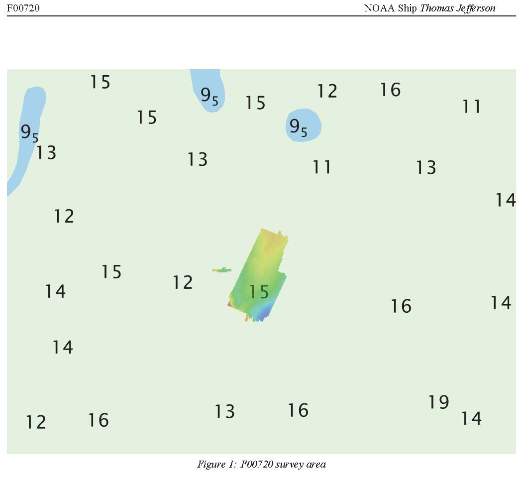
Federal
F00720: NOS Hydrographic Survey , 2018-05-01
National Oceanic and Atmospheric Administration, Department of Commerce —
The National Oceanic and Atmospheric Administration (NOAA) has the statutory mandate to collect hydrographic data in support of nautical chart compilation for safe... -
Federal
JPEG Images of Ground Penetrating Radar (GPR) data collected by East Carolina University along North Carolina Outer Banks 2002-2005
Department of the Interior —
The northeastern North Carolina coastal system, from False Cape, Virginia, to Cape Lookout, North Carolina, has been studied by a cooperative research program that... -
Federal
osu592-20160823T2031-delayed
National Oceanic and Atmospheric Administration, Department of Commerce —
Underwater glider observations from along and near the Newport, Oregon, Hydrographic Line (44-deg 39.1' N) collected as part of a series of long-term studies of... -
Federal
Surface ocean radial velocities obtained by HF-radar from stations located along coastal waters of Hawaii, North Slope Alaska, Gulf of Alaska, Puerto Rico/Virgin Islands, eastern U.S./Gulf of America, western U.S., and the Great Lakes
National Oceanic and Atmospheric Administration, Department of Commerce —
This dataset contains surface ocean radial velocities data obtained by HF-radar from stations located along coastal waters of the United States. Radial velocity files... -
Federal
EnviroAtlas Community Block Group Metrics Web Service
U.S. Environmental Protection Agency —
This EnviroAtlas web service supports research and online mapping activities related to EnviroAtlas (https://www.epa.gov/enviroatlas). This web service includes... -
Federal
L01 Accelerometer - Waves
National Oceanic and Atmospheric Administration, Department of Commerce —
Ocean observation data from the Northeastern Regional Association of Coastal & Ocean Observing Systems (NERACOOS). The NERACOOS region includes the northeast... -
Federal
J04 Buoy Pressure/CTD 5m (Machias Bay)
National Oceanic and Atmospheric Administration, Department of Commerce —
Ocean observation data from the Northeastern Regional Association of Coastal & Ocean Observing Systems (NERACOOS). The NERACOOS region includes the northeast...

Official websites use .gov
A
.gov website belongs to an official government
organization in the United States.
Secure .gov websites use HTTPS
A
lock (
) or https:// means you’ve safely connected to
the .gov website. Share sensitive information only on official,
secure websites.