
-
Federal
Annual wildland fire emissions (WFEIS v0.5) for Conterminous US and Alaska, 2001-2013 NGDA recent views
National Aeronautics and Space Administration —
This data set contains annual modeled estimates of wildland fire emissions at 0.01 degree (~1-km) spatial resolution from the Wildland Fire Emissions Information... -
Federal
LBA-ECO LC-24 Forest Cover Map from MODIS, 500-m, South America: 2001 NGDA recent views
National Aeronautics and Space Administration —
This data set, LBA-ECO LC-24 Forest Cover Map from MODIS, 500-m, South America: 2001, contains forest cover information for 2001 for all of South America. The data... -
Federal
SAFARI 2000 MODIS Water and Heat Fluxes, Maun, Botswana, Dry Season 2001 NGDA recent views
National Aeronautics and Space Administration —
A physically-based model, Energy: Surface Towards Atmosphere (ESTA), was used to model and map the energy and water balances of a heterogeneous land surface in a... -
Federal
ISLSCP II Historical Croplands Cover, 1700-1992 NGDA recent views
National Aeronautics and Space Administration —
The Historical Croplands Cover data set was developed to understand the consequences of historical changes in land use and land cover for ecosystem goods and... -
Federal
SAFARI 2000 1-Degree Estimates of Burned Biomass, Area, and Emissions, 2000 NGDA recent views
National Aeronautics and Space Administration —
A new method is used to generate spatial estimates of monthly averaged biomass burned area and spatial and temporal estimates of trace gas and aerosol emissions from... -
Federal
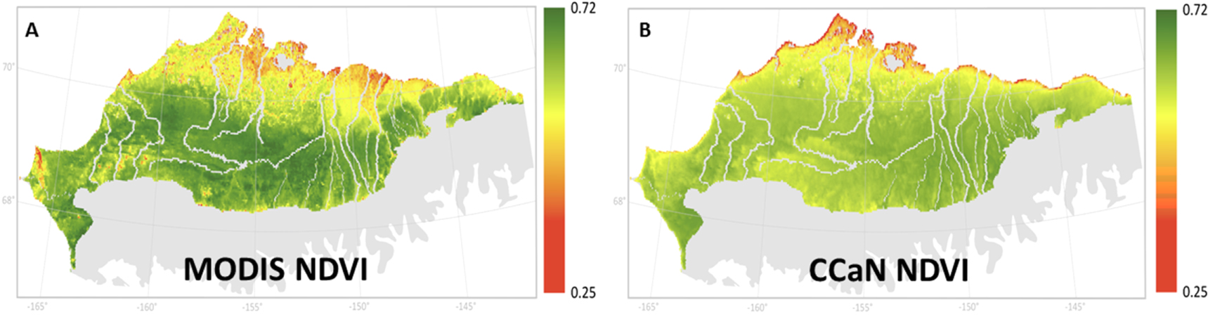
ABoVE: MODIS- and CCAN-Derived NDVI and Trends, North Slope of Alaska, 2000-2015 NGDA recent views
National Aeronautics and Space Administration —
This dataset provides the average Normalized Difference Vegetation Index (NDVI) at 1-km resolution over the north slope of Alaska, USA, for the growing season (June-... -
Federal
NACP VPRM NEE Parameters Optimized to North American Flux Tower Sites, 2000-2006 NGDA recent views
National Aeronautics and Space Administration —
This data set provides Vegetation Photosynthesis Respiration Model (VPRM) net ecosystem exchange (NEE) parameter values optimized to 65 flux tower sites across North... -
Federal
NACP Regional: Supplemental Gridded Observations, Biosphere and Inverse Model Outputs NGDA recent views
National Aeronautics and Space Administration —
This data set contains standardized gridded observation data, terrestrial biospheric model output, and inverse model simulations that were compiled but not used in... -
Federal
ISLSCP II Leaf Area Index (LAI) from Field Measurements, 1932-2000 NGDA recent views
National Aeronautics and Space Administration —
Leaf Area Index (LAI) data from the scientific literature, covering the period from 1932-2000, have been compiled at the Oak Ridge National Laboratory (ORNL)... -
Federal
ISLSCP II Potential Natural Vegetation Cover NGDA recent views
National Aeronautics and Space Administration —
This data set was developed to describe the state of the global land cover in terms of 15 major vegetation types, plus water, before alteration by humans. It forms a... -
Federal
SAFARI 2000 Emissions Estimates, MODIS Burned Area Product, Dry Season 2000 NGDA recent views
National Aeronautics and Space Administration —
The recently generated MODIS burned area product over southern Africa for the month of September 2000 was used to calculate regional biomass burning emissions from... -
Federal
LBA-ECO LC-31 Historical Land-Use in the Amazon: 1940-1995 NGDA recent views
National Aeronautics and Space Administration —
This data set provides annual spatial patterns of cropland, natural pasture, and planted pasture land uses across Amazonia for the period 1940/1950-1995. Two series... -
Federal
LBA-ECO LC-23 Characterization of Vegetation Fire Dynamics for Brazil: 2001-2003 NGDA recent views
National Aeronautics and Space Administration —
Satellite fire detection was determined from two sensors, the Advanced Very High Resolution Radiometer (AVHRR) on NOAA-12 and the Moderate Resolution Imaging... -
Federal
Distribution of Estimated Stand Age Across Siberian Larch Forests, 1989-2012 NGDA recent views
National Aeronautics and Space Administration —
This data set provides mapped estimates of the stand age of young (less than 25 years old) larch forests across Siberia from 1989-2012 at 30-m resolution. The age... -
Federal
Distribution of Young Forests and Estimated Stand Age across Russia, 2012 NGDA recent views
National Aeronautics and Space Administration —
This data set provides the distribution of young forests (forests less than 27 years of age) and their estimated stand ages across the full extent of Russia at 500-m... -
Federal
ABoVE: Burn Severity, Fire Progression, Landcover and Field Data, NWT, Canada, 2014 NGDA recent views
National Aeronautics and Space Administration —
This data set provides peatland landcover classification maps, fire progression maps, and vegetation community biophysical data collected from areas that were burned... -
Federal
ISLSCP II NOAA 5-year Average Monthly Snow-free Albedo from AVHRR NGDA recent views
National Aeronautics and Space Administration —
The objective of this work was to produce a monthly climatology of broadband surface albedos for use in global numerical weather prediction models at the National... -
Federal
NACP Regional: Gridded 1-deg Observation Data and Biosphere and Inverse Model Outputs NGDA recent views
National Aeronautics and Space Administration —
This data set contains standardized gridded observation data, terrestrial biosphere model output data, and inverse model simulations of carbon flux parameters that... -
Federal
ABoVE: Angular-corrected MODIS MAIAC Reflectance across Alaska and Canada, 2000-2017 NGDA recent views
National Aeronautics and Space Administration —
This dataset provides angular corrections of MODIS Multi-Angle Implementation of Atmospheric Correction algorithm (MAIAC) surface reflectances across the ABoVE domain... -
Federal
SAFARI 2000 MODIS 500-m Burned Area Products, Southern Africa, Dry Season 2000 NGDA recent views
National Aeronautics and Space Administration —
The SAFARI 2000 project was selected as the first regional test for a prototype regional 500 m MODIS burned area product. The MODIS burned area product maps the 500 m...

Official websites use .gov
A
.gov website belongs to an official government
organization in the United States.
Secure .gov websites use HTTPS
A
lock (
) or https:// means you’ve safely connected to
the .gov website. Share sensitive information only on official,
secure websites.