
-
Federal
NLDAS Mosaic Land Surface Model L4 Monthly Climatology 0.125 x 0.125 degree V002 (NLDAS_MOS0125_MC) at GES DISC
National Aeronautics and Space Administration —
This monthly climatology data set contains a series of land surface parameters simulated from the Mosaic land-surface model (LSM) for Phase 2 of the North American... -
Federal
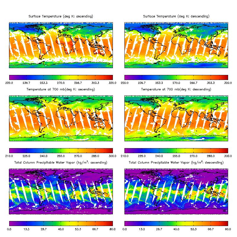
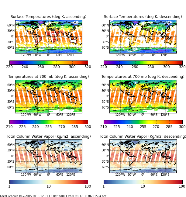
AIRS/Aqua L3 Daily Standard Physical Retrieval (AIRS-only) 1 degree x 1 degree V006 (AIRS3STD) at GES DISC
National Aeronautics and Space Administration —
The Atmospheric Infrared Sounder (AIRS) is a grating spectrometer (R = 1200) aboard the second Earth Observing System (EOS) polar-orbiting platform, EOS Aqua. In... -
Federal
Aqua/AIRS L2 Near Real Time (NRT) Standard Physical Retrieval (AIRS-only) V7.0 at GES DISC
National Aeronautics and Space Administration —
The Atmospheric Infrared Sounder (AIRS) Level 2 Near Real Time (NRT) Standard Physical Retrieval (AIRS-only) product (AIRS2RET_NRT_7.0) differs from the routine... -
Federal
Aqua/AIRS L2 Standard Physical Retrieval (AIRS-only) V7.0 at GES DISC
National Aeronautics and Space Administration —
The Atmospheric Infrared Sounder (AIRS) is a grating spectrometer (R = 1200) aboard the second Earth Observing System (EOS) polar-orbiting platform, EOS Aqua. In... -
Federal
Aqua/AIRS L2 Support Retrieval (AIRS-only) V7.0 at GES DISC
National Aeronautics and Space Administration —
The Atmospheric Infrared Sounder (AIRS) is a grating spectrometer (R = 1200) aboard the second Earth Observing System (EOS) polar-orbiting platform, EOS Aqua. In... -
Federal
NLDAS Mosaic Land Surface Model L4 Hourly 0.125 x 0.125 degree V002 (NLDAS_MOS0125_H) at GES DISC
National Aeronautics and Space Administration —
This data set contains a series of land surface parameters simulated from the Mosaic land-surface model (LSM) for Phase 2 of the North American Land Data Assimilation... -
Federal
NLDAS Mosaic Land Surface Model L4 Hourly 0.125 x 0.125 degree V2.0 (NLDAS_MOS0125_H) at GES DISC
National Aeronautics and Space Administration —
This data set contains thirty-eight fields simulated from the Mosaic land-surface model (LSM) for Phase 2 of the North American Land Data Assimilation System... -
Federal
AIRS/Aqua L3 8-day Standard Physical Retrieval (AIRS+AMSU) 1 degree x 1 degree V006 (AIRX3ST8) at GES DISC
National Aeronautics and Space Administration —
The Atmospheric Infrared Sounder (AIRS) is a grating spectrometer (R = 1200) aboard the second Earth Observing System (EOS) polar-orbiting platform, EOS Aqua. In... -
Federal
Aqua/AIRS L3 Daily Support Product (AIRS-only) 1 degree x 1 degree V7.0 at GES DISC
National Aeronautics and Space Administration —
The Atmospheric Infrared Sounder (AIRS) is a grating spectrometer (R = 1200) aboard the second Earth Observing System (EOS) polar-orbiting platform, EOS Aqua. In... -
Federal
AIRS/Aqua L3 Daily Support Product (AIRS-only) 1 degree x 1 degree V006 (AIRS3SPD) at GES DISC
National Aeronautics and Space Administration —
The Atmospheric Infrared Sounder (AIRS) is a grating spectrometer (R = 1200) aboard the second Earth Observing System (EOS) polar-orbiting platform, EOS Aqua. In... -
Federal
CAR CLASIC BRDF Measurements V2 (CAR_CLASIC_BRDF) at GES DISC
National Aeronautics and Space Administration —
CLASIC (Cloud and Land Surface Interaction Campaign) focuses on advancing the understanding of how land surface processes influence cumulus convection. CLASIC was... -
Federal
CAR Eco-3D Vegetation Response to Changing Forcing Factors L1 V1 (CAR_ECO3D_L1C) at GES DISC
National Aeronautics and Space Administration —
This study promotes the understanding of vegetation response to changing forcing factors such as climate, storm frequency, and management practices, and is directly... -
Federal
CAR SCAR-B Smoke, Clouds, and Radiation-Brazil L1 V1 (CAR_SCARB_L1C) at GES DISC
National Aeronautics and Space Administration —
The objectives for the SCAR mission are to advance our knowledge of how the physical, chemical and radiative processes in our atmosphere are affected by sulfate... -
Federal
NLDAS Mosaic Land Surface Model L4 Monthly Climatology 0.125 x 0.125 degree V2.0 (NLDAS_MOS0125_MC) at GES DISC
National Aeronautics and Space Administration —
This monthly climatology data set contains a series of land surface parameters simulated from the Mosaic land-surface model (LSM) for Phase 2 of the North American... -
Federal
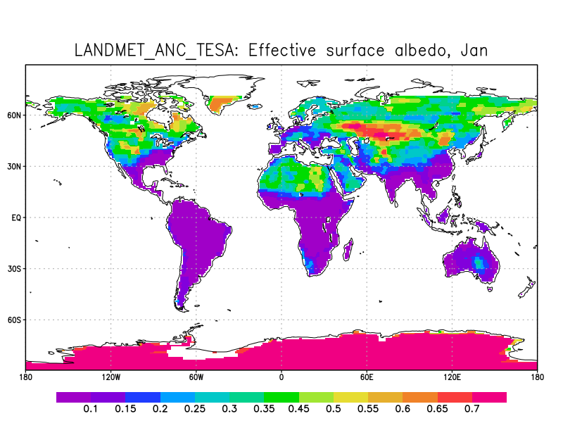
LANDMET Ancillary Monthly Mean Effective and Spectral Albedo Data L3 V1 (LANDMET_ANC_TESA) at GES DISC
National Aeronautics and Space Administration —
This is an ancillary product containing the total effective surface albedo at solar wavelengths originated from the ISCCP FD radiative fluxes product, and the... -
Federal
CAR CLASIC Cloud and Land Surface Measurements L1 V1 (CAR_CLASIC_L1C) at GES DISC
National Aeronautics and Space Administration —
CLASIC (Cloud and Land Surface Interaction Campaign) focuses on advancing the understanding of how land surface processes influence cumulus convection. The CAR flew... -
Federal
CAR SCAR-B BRDF Measurements L1 V2 (CAR_SCARB_BRDF) at GES DISC
National Aeronautics and Space Administration —
The objectives for the SCAR mission are to advance our knowledge of how the physical, chemical and radiative processes in our atmosphere are affected by sulfate... -
Federal
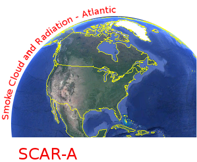
CAR SCAR-A Sulfates, Clouds, and Radiation-Atlantic BRDF Measurements BRDF V2 (CAR_SCARA_BRDF) at GES DISC
National Aeronautics and Space Administration —
The objectives for the SCAR mission are to advance our knowledge of how the physical, chemical and radiative processes in our atmosphere are affected by sulfate... -
Federal
CAR ARMCAS Arctic Cloud BRDF Measurements V2 (CAR_ARMCAS_BRDF) at GES DISC
National Aeronautics and Space Administration —
The Arctic Radiation Measurement in Column Atmosphere-surface System (ARMCAS) was a collaborative research effort between the Cloud and Aerosol Research (CAR) Group,... -
Federal
AIRS/Aqua L3 Daily Standard Physical Retrieval (AIRS+AMSU+HSB) 1 degree x 1 degree V006 (AIRH3STD) at GES DISC
National Aeronautics and Space Administration —
The Atmospheric Infrared Sounder (AIRS) is a grating spectrometer (R = 1200) aboard the second Earth Observing System (EOS) polar-orbiting platform, EOS Aqua. In...

Official websites use .gov
A
.gov website belongs to an official government
organization in the United States.
Secure .gov websites use HTTPS
A
lock (
) or https:// means you’ve safely connected to
the .gov website. Share sensitive information only on official,
secure websites.