
-
Federal
First ISCCP Regional Experiment (FIRE) Atlantic Stratocumulus Transition Experiment (ASTEX) Centre Meteorologie Spatiale (CMS) Daily Solar Irradiance Data recent views
National Aeronautics and Space Administration —
The First ISCCP Regional Experiments have been designed to improve data products and cloud/radiation parameterizations used in general circulation models (GCMs).... -
Federal
FLDAS Noah Land Surface Model L4 Global Monthly Anomaly 0.1 x 0.1 degree (MERRA-2 and CHIRPS) V001 (FLDAS_NOAH01_C_GL_MA) at GES DISC recent views
National Aeronautics and Space Administration —
The monthly anomaly data set contains a series of land surface parameters simulated from the Noah 3.6.1 model in the Famine Early Warning Systems Network (FEWS NET)... -
Federal
CARVE: L1 In-situ Carbon and CH4 Flux and Meteorology at EC Towers, Alaska, 2011-2015 recent views
National Aeronautics and Space Administration —
This data set provides ground in situ flux and meteorological science data from fixed instruments at three eddy covariance tower sites located in the Alaskan Arctic... -
Federal
TES/Aura L2 Ancillary Special Observation Product V007 recent views
National Aeronautics and Space Administration —
TL2ANCS_7 is the Tropospheric Emission Spectrometer (TES)/Aura Level 2 Ancillary Special Observation Product Version 7 data product. TES was an instrument aboard... -
Federal
DISCOVER-AQ Colorado Deployment Ozonesonde Data recent views
National Aeronautics and Space Administration —
DISCOVERAQ_Colorado_Ozonesondes_Data contains data collected via ozonesonde launches at the Platteville ground site during the Colorado (Denver) deployment of NASA's... -
Federal
GOZCARDS Source Ozone 1 month L3 10 degree Zonal Means on a Vertical Pressure Grid V1 (GozSmlpO3) at GES DISC recent views
National Aeronautics and Space Administration —
The GOZCARDS Source Data for Ozone 1 month L3 10 degree Zonal Averages on a Vertical Pressure Grid product (GozSmlpO3) contains zonal means and related information... -
Federal
CATS-ISS Level 2 Operational Day Mode 7.1 Version 3-01 5 km Layer recent views
National Aeronautics and Space Administration —
CATS-ISS_L2O_D-M7.1-V3-01_05kmLay is the Cloud-Aerosol Transport System (CATS) International Space Station (ISS) Level 2 Operational Day Mode 7.1 Version 3-01 5 km... -
Federal
ARCTAS DC-8 Aircraft In-situ Aerosol Data recent views
National Aeronautics and Space Administration —
ARCTAS_Aerosol_AircraftInSitu_DC8_Data is the in-situ aerosol data for the DC-8 aircraft collected during the Arctic Research of the Composition of the Troposphere... -
Federal
TROPESS OMI-Aura L2 Ozone for Forward Stream, Standard Product V1 (TRPSDL2O3OMIFS) at GES DISC recent views
National Aeronautics and Space Administration —
The TROPESS OMI-Aura L2 Ozone for Forward Stream, Standard Product contains the vertical distribution of the retrieved atmospheric state of ozone (O3), formal... -
Federal
DISCOVER-AQ California Deployment Pandora Column Observations recent views
National Aeronautics and Space Administration —
DISCOVERAQ_California_Pandora_Data contains all of the Pandora instrumentation data collected during the DISCOVER-AQ field study. Contained in this dataset are column... -
Federal
GEWEX SRB Integrated Product (Rel-4) Longwave Daily Average by UTC recent views
National Aeronautics and Space Administration —
GEWEXSRB_Rel4-IP_Longwave_daily_utc is the Global Energy and Water Exchanges (GEWEX) Surface Radiation Budget (SRB) Integrated Product (Rel-4) Longwave Daily Average... -
Federal
NASA Water Vapor Project MEaSUREs (NVAP-M) CLIMATE Layered Precipitable Water recent views
National Aeronautics and Space Administration —
NVAP_CLIMATE_Layered-Precipitable-Water data set is designed to provide the most stable water vapor data set over time for use in climate applications. NVAP-M Climate... -
Federal
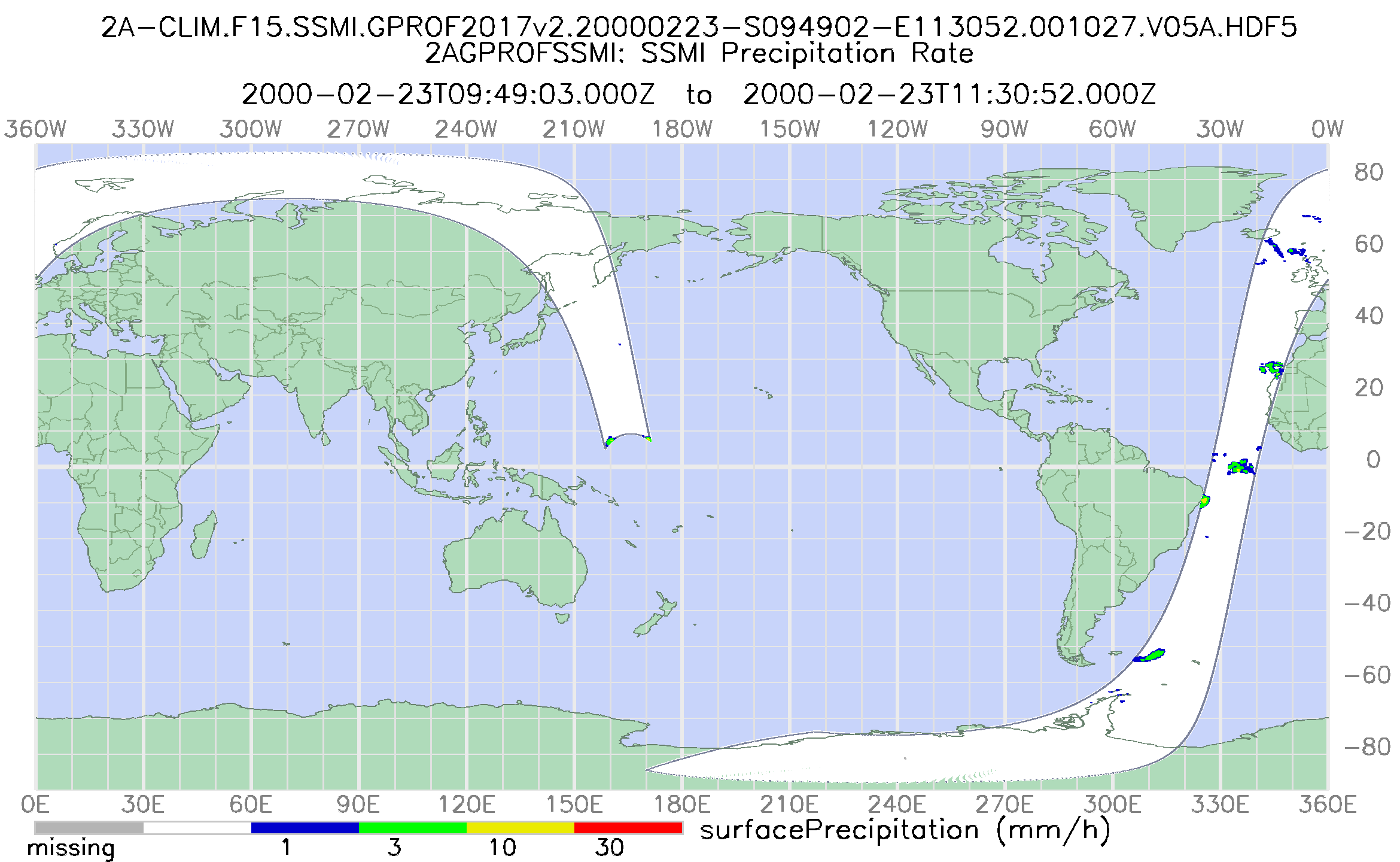
GPM SSM/I on F15 (GPROF) Climate-based Radiometer Precipitation Profiling L2 1.5 hours 12 km V07 (GPM_2AGPROFF15SSMI_CLIM) at GES DISC recent views
National Aeronautics and Space Administration —
Version 07 is the current version of the data set. Older versions will no longer be available and have been superseded by Version 07. The 'CLIM' products differ from... -
Federal
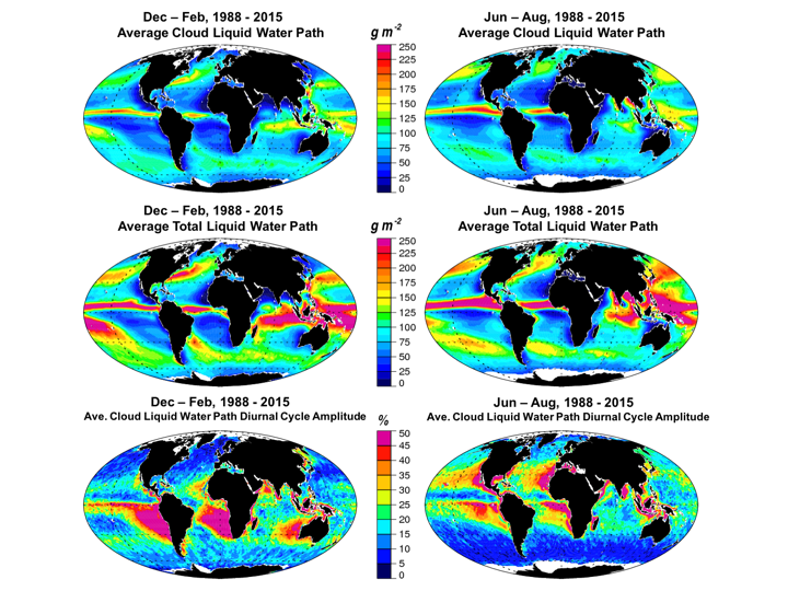
Multisensor Advanced Climatology Total Liquid Water Path L3 Monthly 1 degree x 1 degree V1 (MACTWP_mean) at GES DISC recent views
National Aeronautics and Space Administration —
The Multi-Sensor Advanced Climatology of Liquid Water Path (MAC-LWP) data set contains monthly 1.0-degree ocean-only estimates of cloud liquid water path... -
Federal
GPM ATMS on NOAA-21 (GPROF) Climate-based Radiometer Precipitation Profiling L2A 1.5 hours 17 km V07 (GPM_2AGPROFNOAA21ATMS_CLIM) at GES DISC recent views
National Aeronautics and Space Administration —
Version 07 is the current version of the data set. The "CLIM" products differ from their "regular" counterparts (without the "CLIM" in the name) by the ancillary data... -
Federal
TAO/TRITON, RAMA, and PIRATA Buoys, Monthly, 1977-present, Air Temperature recent views
National Oceanic and Atmospheric Administration, Department of Commerce —
This dataset has monthly Air Temperature data from the TAO/TRITON (Pacific Ocean, https://www.pmel.noaa.gov/gtmba/ ), RAMA (Indian Ocean,... -
Federal
MODIS/Aqua Total Precipitable Water Vapor 5-Min L2 Swath 1km and 5km - NRT NGDA recent views
National Aeronautics and Space Administration —
The MODIS Adaptive Processing System (MODAPS) is currently generating an improved Collection 6.1 (061) for all MODIS Level-1 (L1) and higher-level Level-2 (L2) and... -
Federal
MLS/Aura Level 3 Daily Binned Nitrous Oxide (N2O) Mixing Ratio on Zonal and Similar Grids V005 (ML3DZN2O) at GES DISC recent views
National Aeronautics and Space Administration —
ML3DZN2O is the EOS Aura Microwave Limb Sounder (MLS) daily binned on zonal and assorted vertical grids product for nitrous oxide (N2O) derived from radiances... -
Federal
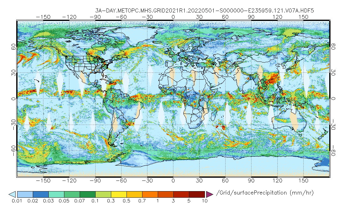
GPM MHS on METOP-C (GPROF) Radiometer Precipitation Profiling L3 1 day 0.25 degree x 0.25 degree V07 (GPM_3GPROFMETOPCMHS_DAY) at GES DISC recent views
National Aeronautics and Space Administration —
Version 07 is the current version of the data set. 3GPROF products provide global gridded monthly/daily precipitation averages from multiple satellites that can be... -
Federal
NOAA-20 VIIRS Regional Ocean Color (OC) - Near Real Time (NRT) Data, version R2022.0 recent views
National Aeronautics and Space Administration —
The Ocean Biology DAAC produces near real-time (quicklook) products using the best-available combination of ancillary data from meteorological and ozone data. As...

Official websites use .gov
A
.gov website belongs to an official government
organization in the United States.
Secure .gov websites use HTTPS
A
lock (
) or https:// means you’ve safely connected to
the .gov website. Share sensitive information only on official,
secure websites.