
-
Federal
Arctic Vegetation Plots in Northern NWT and YT, Canada, 1965-1966
National Aeronautics and Space Administration —
This dataset provides vegetation, soil, and plot characteristics for 154 study plots located at three sites across the Richardson Mountains, Northwest Territories... -
Federal
Arctic Vegetation Plots from Pingo Communities, North Slope, Alaska, 1984-1986
National Aeronautics and Space Administration —
This data set provides vegetation species and vegetation plot data collected between 1983 and 1985 from 293 study plots on 41 pingos on the North Slope of Alaska. The... -
Federal
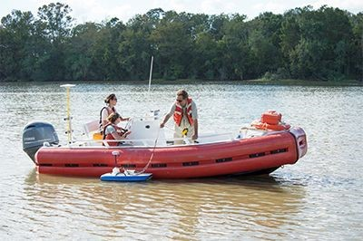
Pre-Delta-X: River Discharge Channel Surveys across Atchafalaya Basin, LA, USA, 2016
National Aeronautics and Space Administration —
This dataset provides river discharge measurements collected at selected locations across the Atchafalaya River Basin, within the Mississippi River Delta (MRD)... -
Federal
ERS-2_LEVEL0
National Aeronautics and Space Administration —
ERS-2 Standard Beam Data Level 0 -
Federal
Digital Linework (1979-2008) Associated With Eastern Denali Fault Surface Trace Map, Eastern Alaska and Adjacent Canada
Department of the Interior —
This data set provides the first detailed (1:2,000 to 1:10,000) digital map of the ~385 km long surface trace of the right-lateral strike-slip Denali Fault from the... -
Federal
Pre-Delta-X: Spectral Reflectance of Water Surface, Atchafalaya Basin, LA, USA, 2016
National Aeronautics and Space Administration —
This dataset provides measurements of in situ remote-sensing reflectance (Rrs; per steradian) of surface water across Atchafalaya Basin, southern coastal Louisiana,... -
Federal
Pre-Delta-X: Channel Bathymetry of the Atchafalaya Basin, LA, USA, 2016
National Aeronautics and Space Administration —
This dataset provides water depths and water surface elevations collected during bathymetric surveys of the main channel of the Wax Lake Delta within the Mississippi... -
Federal
BOREAS TE-01 Soils Data over the SSA Tower Sites in Raster Format
National Aeronautics and Space Administration —
Gridded from vector layers of soil maps that were received from Dr. Darwin Anderson TE-01, who did the original soil mapping in the field during 1994. The vector... -
Federal
Heat Capacity Mapping Mission (HCMM)
National Aeronautics and Space Administration —
The mission was the first of a series of NASA Applications Explorer Missions and is also known as AEM-A. Day/night coverage over a given area occurred at intervals... -
Federal
SRTM Water Body Data
National Aeronautics and Space Administration —
The SRTM Water Body Data files are a by-product of the data editing performed by the National Geospatial-Intelligence Agency (NGA) to produce the finished SRTM... -
Federal
Photogrammetric Digital Elevation Model (1979-1989) Associated With Eastern Denali Fault Surface Trace Map, Eastern Alaska and Adjacent Canada
Department of the Interior —
This data set provides a photogrammetry-based digital elevation model (DEM) that covers ~90% of the surface trace of the Eastern Denali Fault between the Alaska-Yukon... -
Federal
HDDS_Baseline_Adhoc
National Aeronautics and Space Administration —
The U.S. Geological Survey (USGS) Emergency Operations, in support of the Department of Homeland Security, provides imagery and resources for use in disaster... -
Federal
Airborne Lidar-based Digital Elevation Models of Coastal Montague Island (Alaska) Acquired September 2018
Department of the Interior —
This dataset provides a digital elevation model mosaic derived from airborne lidar data acquired in 2018 from September 2–3 over eight separate areas along Alaska's... -
Federal
Radiocarbon and Luminescence Data for Fairweather Fault Investigation, Glacier Bay National Park, Southeast Alaska
Department of the Interior —
This dataset is comprised of two tables with age data along the Fairweather fault in Glacier Bay Nation Park. The tables are: (1) radiocarbon dates analyzed at the... -
Federal
SENTINEL-1A_SINGLE_POL_GRD_MEDIUM_RES
National Aeronautics and Space Administration —
Sentinel-1A Single-pol ground projected medium resolution images -
Federal
SENTINEL-1B_DUAL_POL_GRD_HIGH_RES
National Aeronautics and Space Administration —
Sentinel-1B Dual-pol ground projected high and full resolution images -
Federal
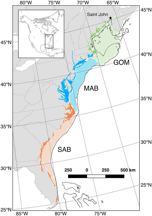
Mean Annual Fluxes of Carbon in Coastal Ecosystems of Eastern North America
National Aeronautics and Space Administration —
This dataset contains best estimates and uncertainties for mean annual fluxes of inorganic, organic, and total (organic + inorganic) carbon in tidal wetlands,... -
Federal
SENTINEL-1B_RAW
National Aeronautics and Space Administration —
Sentinel-1B level zero product -
Federal
SENTINEL-1B_METADATA_RAW
National Aeronautics and Space Administration —
Metadata for Sentinel-1B level zero product

Official websites use .gov
A
.gov website belongs to an official government
organization in the United States.
Secure .gov websites use HTTPS
A
lock (
) or https:// means you’ve safely connected to
the .gov website. Share sensitive information only on official,
secure websites.