
-
City
5.14 Audit Completion Rate (detail)
City of Tempe —
This page provides data for the Internal Audit Plan performance measure.Descriptions and status for audit plan projects. The performance measure dashboard is... -
Federal
NOAA/WDS Paleoclimatology - CLIMAP 18K Database
National Oceanic and Atmospheric Administration, Department of Commerce —
This archived Paleoclimatology Study is available from the NOAA National Centers for Environmental Information (NCEI), under the World Data Service (WDS) for... -
Federal
GoM Estuarine Bottlenose Dolphin Photo-identification studies - NRDA
National Oceanic and Atmospheric Administration, Department of Commerce —
These data sets include a compilation of small vessel based studies of bottlenose dolphins that reside within Barataria Bay, LA, Mississippi Sound, MS and nearshore... -
Federal
FIA Landcover County Estimates - 2015 (Feature Layer)
Department of Agriculture —
This feature class represents forest area estimates (and percent sampling error) by county for the year 2015. The data was generated from the Forest Inventory... -
Federal
Data from the Inventory of Montane-nesting Birds in the Aniakchak National Monument and Preserve, Alaska
Department of the Interior —
This data package includes two child items with data from montane-nesting bird surveys in the Aniakchak National Monument and Preserve, Alaska. Child Item One: "Data... -
Federal
Canine distemper virus antibody titer results for grizzly bears and wolves in the Greater Yellowstone Ecosystem 1984-2014
Department of the Interior —
We investigated the dynamics of canine distemper virus (CDV) in grizzly bears (Ursus arctos) and wolves (Canis lupus) of the Greater Yellowstone Ecosystem (GYE) using... -
Federal
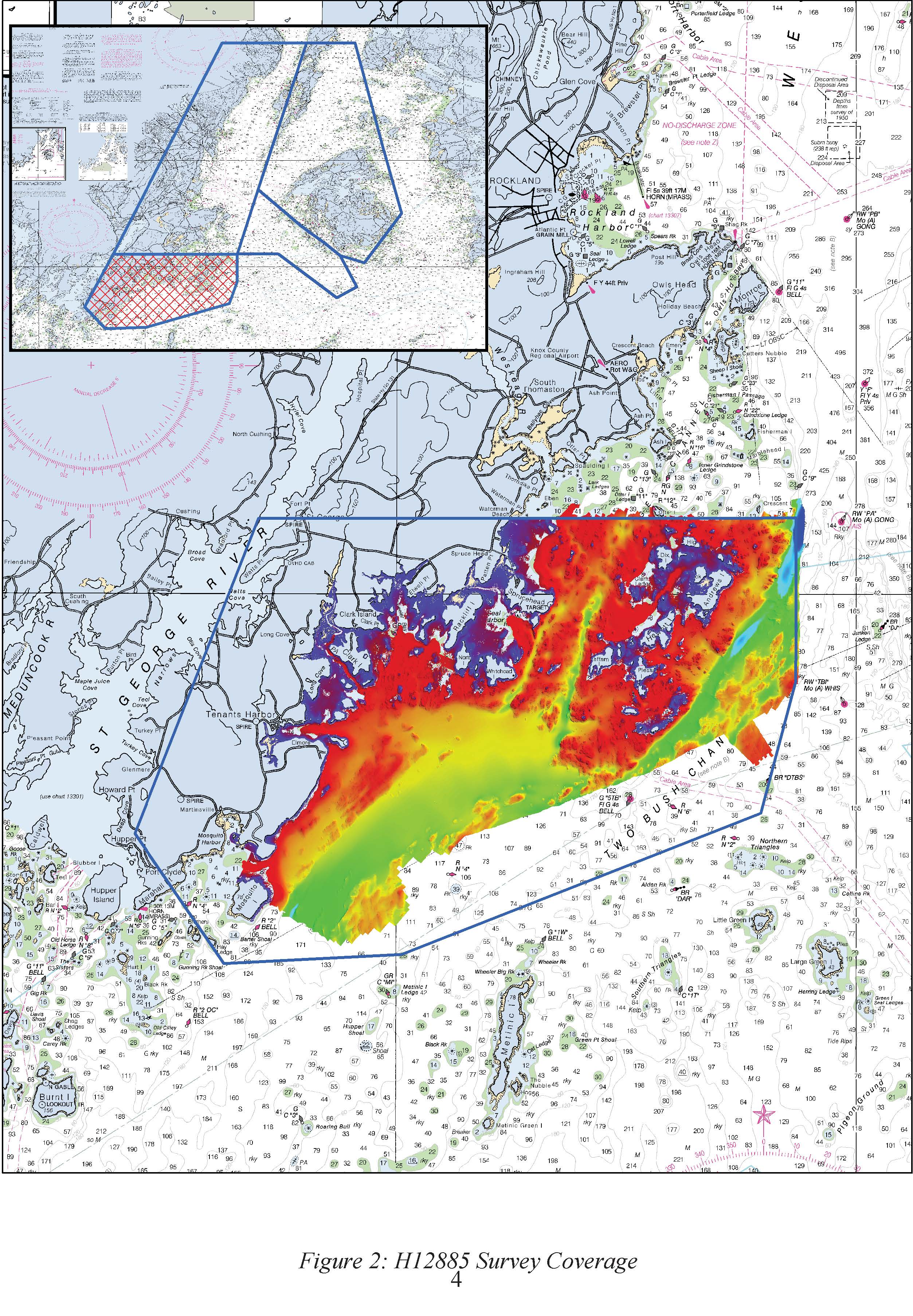
H12885: NOS Hydrographic Survey , 2016-09-29
National Oceanic and Atmospheric Administration, Department of Commerce —
The National Oceanic and Atmospheric Administration (NOAA) has the statutory mandate to collect hydrographic data in support of nautical chart compilation for safe... -
University
1935 15' Quad #291 Aerial Photo Mosaic Index
Earth Data Analysis Center, University of New Mexico —
Aerial Photo Reference Mosaics contain aerial photographs that are retrievable on a frame by frame basis. The inventory contains imagery from various sources that are... -
Federal
Development and field testing of satellite-linked fluorometers for marine mammals
National Oceanic and Atmospheric Administration, Department of Commerce —
This dataset includes telemetry data related to the development and testing of an animal-borne satellite-linked fluorometer tag, used on northern fur seals and... -
Federal
B00048: NOS Hydrographic Survey , 1986-06-29
National Oceanic and Atmospheric Administration, Department of Commerce —
The National Oceanic and Atmospheric Administration (NOAA) has the statutory mandate to collect hydrographic data in support of nautical chart compilation for safe... -
Federal
B00052: NOS Hydrographic Survey , 1986-05-29
National Oceanic and Atmospheric Administration, Department of Commerce —
The National Oceanic and Atmospheric Administration (NOAA) has the statutory mandate to collect hydrographic data in support of nautical chart compilation for safe... -
Federal
FIA Landcover County Estimates - 2017 (Feature Layer)
Department of Agriculture —
This feature class represents forest area estimates (and percent sampling error) by county for the year 2017. The data was generated from the Forest Inventory... -
Federal
AMSR-E/AMSR2 Unified L3 Global Weekly Ascending/Descending .25x.25 deg Ocean Grids V001
National Aeronautics and Space Administration —
The AMSR-E/AMSR2 Unified L3 Global Weekly Ascending/Descending .25 x .25 deg Ocean Grids data set (AU_WkOcn) reports weekly estimates of water vapor, cloud liquid... -
State
Regional Drainage Basin Set
State of Connecticut —
See full Data Guide here. Regional Drainage Basin Set: Connecticut Regional Drainage Basins is 1:24,000-scale, polygon and line feature data that define Regional... -
County
1980 Lake County Aerial Color InfraRed (CIR)
Lake County, Illinois —
This four foot pixel resolution color infrared aerial photography was purchased from the U. S. Department of Agriculture Aerial Photography Field Office, 2222 West... -
City
2.11 Financial Reporting Award (summary)
City of Tempe —
The Certificate of Achievement for Excellence in Financial Reporting is the highest form of recognition in governmental accounting and financial reporting,... -
Federal
"LATEX CTD - d93f061.nc - 28.84N, 92.0W - 1993-07-29"
National Oceanic and Atmospheric Administration, Department of Commerce —
The Louisiana-Texas Shelf Physical Oceanography Program (LATEX) was sponsored by the Minerals Management Service (MMS) of the U.S. Department of the Interior. Of its... -
State
Regional Drainage Basin Polygon
State of Connecticut —
See full Data Guide here. Regional Drainage Basin Set: Connecticut Regional Drainage Basins is 1:24,000-scale, polygon and line feature data that define Regional... -
Federal
NOAA/WDS Paleoclimatology - Serre-Bachet - Mt. Ventoux - ABAL - ITRDB FRAN7
National Oceanic and Atmospheric Administration, Department of Commerce —
This archived Paleoclimatology Study is available from the NOAA National Centers for Environmental Information (NCEI), under the World Data Service (WDS) for...

Official websites use .gov
A
.gov website belongs to an official government
organization in the United States.
Secure .gov websites use HTTPS
A
lock (
) or https:// means you’ve safely connected to
the .gov website. Share sensitive information only on official,
secure websites.