

277 datasets found for "Shellfish Growing Areas"
-
Federal
A gridded database of the modern distributions of climate, woody plant taxa, and ecoregions for the continental United States and Canada
Department of the Interior —
On the continental scale, climate is an important determinant of the distributions of plant taxa and ecoregions. To quantify and depict the relations between specific... -
Federal
Data from monitoring of shellfish for Paralytic Shellfish Poisoning (PSP) and Domoic Acid Poisoning (DAP) by the Washington State Department of Health, 1989-1999 (NCEI Accession 0000580)
National Oceanic and Atmospheric Administration, Department of Commerce —
The state of Washington routinely experiences seasonal restrictions on commercial and recreational shellfish harvest due to two toxic phytoplankton syndromes,... -
Federal
Spring Bottom Trawl Survey
National Oceanic and Atmospheric Administration, Department of Commerce —
The standardized NEFSC Spring Bottom Trawl Survey was initiated in 1968 and covered an area from Cape Hatteras, NC, to Nova Scotia, Canada, at depths >27m.... -
Federal
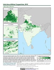
India Annual Winter Cropped Area, 2001-2016 NGDA
National Aeronautics and Space Administration —
The India Annual Winter Cropped Area, 2001 - 2016 consists of annual winter cropped areas for most of India (except the Northeastern states) from 2000-2001 to... -
State
Shellfish Area Class Line
State of Connecticut —
Shellfish Area Classification Set: The Connecticut Department of Environmental Protection cooperated with the Department of Agriculture, Bureau of Aquaculture to... -
State
Shellfish Beds Managed Set
State of Connecticut —
Shellfish Beds Managed Set: The Connecticut Department of Environmental Protection cooperated with the Department of Agriculture, Bureau of Aquaculture to publish the... -
Federal
Great Smoky Mountains National Park Exotics Species Locations
Department of the Interior —
Exotic plants are species that have been introduced to an ecosystem by human activities. Usually exotics come from other countries or continents, but they may also... -
Federal
BLM AZ Wilderness
Department of the Interior —
This dataset includes the polygon features representing the spatial extent and boundaries of the Bureau of Land Management (BLM) National Landscape Conservation... -
Federal
Annual General Canvass Statistics
National Oceanic and Atmospheric Administration, Department of Commerce —
This data set contains annual quantities and value for all seafood products that are landed and sold by established seafood dealers and brokers in the Southeast... -
Federal
Estimated crop irrigation water use withdrawals in Harquahala Irrigation Non-Expansion Area Groundwater Basin, Arizona for 2023
Department of the Interior —
Observations of irrigated agricultural land within the Harquahala Irrigation Non-Expansion Area Groundwater Basin in Arizona. Crops were verified in situ three times... -
Federal
Vegetation height in open space in San Diego County, derived from 2014 NAIP imagery and 2014/2015 lidar
Department of the Interior —
Shrublands have seen large changes over time due to factors such as fire and drought. As the climate continues to change, vegetation monitoring at the county scale is... -
Federal
Arundo donax (Arundo Cane) Image Classification along the Rio Grande in Webb County, Texas, 2020–2021
Department of the Interior —
This data release contains geospatial thematic (classified) images and vector (polygon) data derived from WorldView-3 satellite imagery. Imagey was obtained during... -
Federal
Base Terrain and Bathymetry for the Middle Mississippi River
Department of the Interior —
Within large-river ecosystems, floodplains serve a variety of important ecological functions. A recent survey of 80 managers of floodplain conservation lands along... -
Federal
USGS public distribution of FSA 10:1 NAIP Imagery Downloadable Data Collection from The National Map
Department of the Interior —
This data set collection contains imagery from the National Agriculture Imagery Program (NAIP). The NAIP program is administered by USDA FSA and has been established... -
Federal
Synoptic study of glyphosate, neonicotinoids, and selected other pesticides in streams draining to Lake Champlain from urban and agricultural sources near Burlington, Vermont, 2021
Department of the Interior —
A study designed to measure concentrations of glyphosate, aminomethylphosphonic acid (AMPA, a product of glyphosate degradation in the environment), and several... -
Federal
Global temperate drylands climate change vulnerability
Department of the Interior —
Drylands cover 40% of the global terrestrial surface and provide important ecosystem services. While drylands as a whole are expected to increase in distribution and... -
Federal
Estimated crop irrigation water use withdrawals in Hualapai Valley Groundwater Basin, Arizona for 2020
Department of the Interior —
Observations of irrigated agricultural land within the Hualapai Valley Groundwater Basin in Arizona. Crops were verified in situ once in 2020 on July 16th; based on... -
Federal
Migration Routes of Elk in Gooseberry Herd in Wyoming
Department of the Interior —
Elk (Cervus elpahus canadensis) within the southern section of the Absaroka Range display altitudinal migration. In the spring, they migrate from the eastern... -
Federal
ShellBase- Southeast Shellfish Water Quality Database for Florida, Georgia, South Carolina, and North Carolina Coastal Waters, 1979-2020 (NCEI Accession 0248227)
National Oceanic and Atmospheric Administration, Department of Commerce —
ShellBase is a normal-form database including historical bacteriological monitoring data collected in shellfish waters of North Carolina (NC), South Carolina (SC),... -
Federal
BLM AZ Wilderness Study Area (Polygon)
Department of the Interior —
This dataset includes the polygon features representing the spatial extent and boundaries of the Bureau of Land Management (BLM) National Landscape Conservation...
277 datasets found for "Shellfish Growing Areas"