
-
Federal
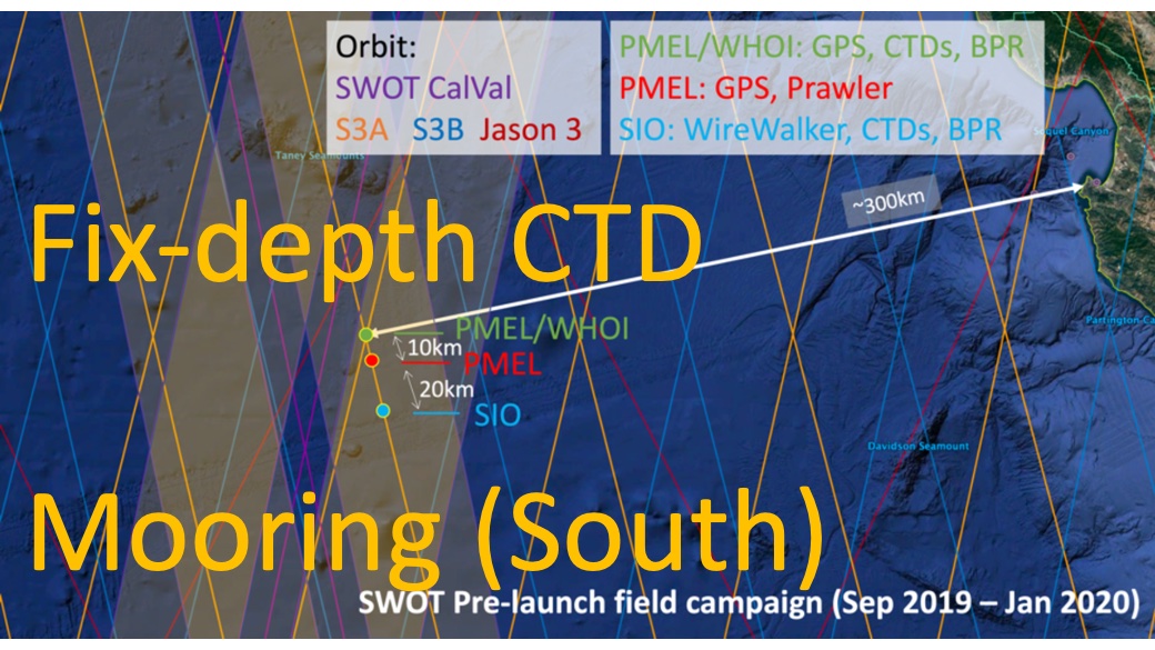
SWOT 2019-2020 Prelaunch Oceanography Field Campaign SIO Moored Fixed-Depth CTDs
National Aeronautics and Space Administration —
This dataset provides the conductivity, temperature and depth (CTD) measurements from the fixed-depth CTD sensors mounted on a full-depth mooring deployed by the SWOT... -
Federal
GHRSST Level 2P NOAA STAR SST v2.80 from VIIRS on S-NPP Satellite
National Aeronautics and Space Administration —
The Joint Polar Satellite System (JPSS), starting with S-NPP launched on 28 October 2011, is the new generation of the US Polar Operational Environmental Satellites... -
Federal
SPURS-2 Passive Accoustic Listener (PAL) data from ARGO float deployments during the E. Tropical Pacific field campaign
National Aeronautics and Space Administration —
The SPURS (Salinity Processes in the Upper Ocean Regional Study) project is a NASA-funded oceanographic process study and associated field program that aim to... -
Federal
GHRSST NOAA/STAR Metop-A AVHRR FRAC ACSPO v2.80 1km L2P Dataset (GDS v2)
National Aeronautics and Space Administration —
The MetOp First Generation (FG) is a European multi-satellite program jointly established by ESA and EUMETSAT, comprising three satellites, MetOp-A, -B and -C. The... -
Federal
ECCO Ocean Velocity - Monthly Mean 0.5 Degree (Version 4 Release 4)
National Aeronautics and Space Administration —
This dataset contains monthly-averaged ocean velocity interpolated to a regular 0.5-degree grid from the ECCO Version 4 revision 4 (V4r4) ocean and sea-ice state... -
Federal
ECCO Gent-McWilliams Ocean Bolus Velocity - Monthly Mean 0.5 Degree (Version 4 Release 4)
National Aeronautics and Space Administration —
This dataset contains monthly-averaged Gent-McWilliams ocean bolus velocity interpolated to a regular 0.5-degree grid from the ECCO Version 4 revision 4 (V4r4) ocean... -
Federal
ECCO Sea-Ice Salt Plume Fluxes - Monthly Mean llc90 Grid (Version 4 Release 4)
National Aeronautics and Space Administration —
This dataset provides monthly-averaged sea-ice salt plume fluxes on the native Lat-Lon-Cap 90 (LLC90) model grid from the ECCO Version 4 Release 4 (V4r4) ocean and... -
Federal
Aquarius Official Release Level 3 Sea Surface Salinity Standard Mapped Image Descending Daily Data V5.0
National Aeronautics and Space Administration —
Aquarius Level 3 sea surface salinity (SSS) standard mapped image data contains gridded 1 degree spatial resolution SSS averaged over daily, 7 day, monthly, and... -
Federal
JPL GRACE and GRACE-FO Mascon Ocean, Ice, and Hydrology Equivalent Water Height Coastal Resolution Improvement (CRI) Filtered Release 06.1 Version 03
National Aeronautics and Space Administration —
This dataset contains gridded monthly global water storage/height anomalies relative to a time-mean, derived from GRACE and GRACE-FO and processed at JPL using the... -
Federal
Monthly gridded Global Land Data Assimilation System (GLDAS) from Noah-v3.3 land hydrology model for GRACE and GRACE-FO over nominal months
National Aeronautics and Space Administration —
The total land water storage anomalies are aggregated from the Global Land Data Assimilation System (GLDAS) NOAH model. GLDAS outputs land water content by using... -
Federal
GHRSST NOAA/STAR ACSPO v2.81 0.02 degree L3S Daily Dataset from LEO Satellites NGDA
National Aeronautics and Space Administration —
The L3S_LEO_DY-STAR-v2.81 dataset produced by the NOAA Advanced Clear-Sky Processor for Ocean (ACSPO) system derives the Subskin Sea Surface Temperature (SST) from... -
Federal
SWOT Level 1B Low-Rate Interferogram Data Product, Version 2.0
National Aeronautics and Space Administration —
Interferograms for each of the 9 Doppler beams formed and spatially averaged (low rate) by the On Board Processor, corrected on the ground for phase biases (inherent... -
Federal
OMG Narwhals Shipboard Conductivity, Temperature, and Depth (CTD) profiles, 2018-2020
National Aeronautics and Space Administration —
This OMG Narwhals dataset contains measurements from the ship based full water column CTD profiles that were obtained during summer mooring deployment/recovery... -
Federal
MetOp-A ASCAT Scatterometer Inter-Calibrated ESDR Level 2 Ocean Surface Equivalent Neutral Wind Vectors and Wind Stress Vectors Version 1.1
National Aeronautics and Space Administration —
This dataset contains ocean surface wind vectors (equivalent neutral and true 10m) and wind stress vectors derived from satellite-based scatterometer observations... -
Federal
MODIS Terra Level 3 SST MID-IR Daily 9km Nighttime V2019.0 NGDA
National Aeronautics and Space Administration —
Day and night spatially gridded (L3) global NASA skin sea surface temperature (SST) products from the Moderate-resolution Imaging Spectroradiometer (MODIS) onboard... -
Federal
Pre SWOT Hydrology Global Lake/Reservoir Surface Inland Water Height GREALM V.2
National Aeronautics and Space Administration —
The Global Lake/Reservoir Surface Inland Water Height Time Series is derived from the G-REALM10 lake level product... -
Federal
Aquarius Official Release Level 3 Sea Surface Salinity Standard Mapped Image Seasonal Data V5.0
National Aeronautics and Space Administration —
Aquarius Level 3 sea surface salinity (SSS) standard mapped image data contains gridded 1 degree spatial resolution SSS averaged over daily, 7 day, monthly, and... -
Federal
SASSIE Arctic Field Campaign Shipboard Salinity Snake Data Fall 2022
National Aeronautics and Space Administration —
The Salinity and Stratification at the Sea Ice Edge (SASSIE) project is a NASA experiment that aims to understand how salinity anomalies in the upper ocean generated... -
Federal
GHRSST NOAA/STAR Metop-C AVHRR FRAC ACSPO v2.80 0.02 L3U Dataset (GDS v2)
National Aeronautics and Space Administration —
This L3U (Level 3 Uncollated) dataset contains global daily Sea Surface Temperature (SST) on a 0.02 degree grid resolution. It is produced by the National Oceanic and... -
Federal
MODIS Aqua Level 3 SST MID-IR Daily 4km Nighttime V2019.0 NGDA
National Aeronautics and Space Administration —
Day and night spatially gridded (L3) global NASA skin sea surface temperature (SST) products from the Moderate-resolution Imaging Spectroradiometer (MODIS) onboard...

Official websites use .gov
A
.gov website belongs to an official government
organization in the United States.
Secure .gov websites use HTTPS
A
lock (
) or https:// means you’ve safely connected to
the .gov website. Share sensitive information only on official,
secure websites.