
-
Federal
HIRDLS/Aura Level 3 Dinitrogen Pentoxide (N2O5) 1deg Lat Zonal Fourier Coefficients V007 (H3ZFCN2O5) at GES DISC recent views
National Aeronautics and Space Administration —
The "HIRDLS/Aura Level 3 Dinitrogen Pentoxide (N2O5) Zonal Fourier Coefficients" version 7 data product (H3ZFCN2O) contains the entire mission (~3 years) of HIRDLS... -
Federal
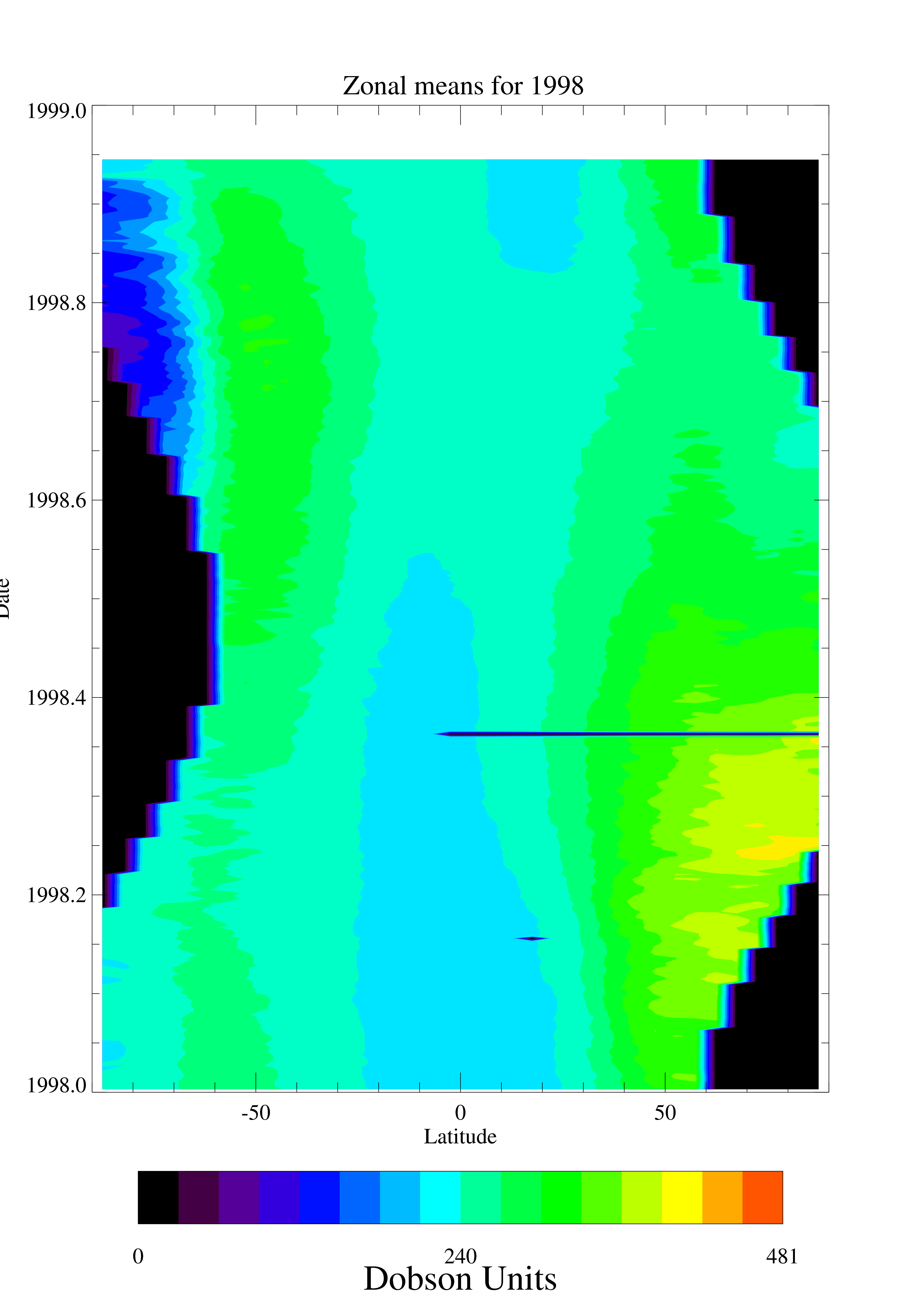
TOMS EP Total Column Ozone Daily and Monthly Zonal Means V008 (TOMSEPL3ztoz) at GES DISC recent views
National Aeronautics and Space Administration —
This Earth Probe (EP) Total Ozone Mapping Spectrometer (TOMS) version 8 daily zonal means data product contains total column ozone values. The data are averaged in 5... -
Federal
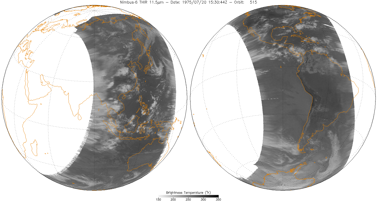
THIR/Nimbus-6 Level 1 Meteorological Radiation Data at 11.5 microns V001 (THIRN6L1CH115) at GES DISC recent views
National Aeronautics and Space Administration —
THIRN6L1CH115 is the Nimbus-6 Temperature-Humidity Infrared Radiometer (THIR) Level 1 Meteorological Radiation Data at 11.5 microns product and contains radiances... -
Federal
GOZCARDS Source Ozone 1 month L3 10 degree Zonal Means on a Vertical Pressure Grid V1 (GozSmlpO3) at GES DISC recent views
National Aeronautics and Space Administration —
The GOZCARDS Source Data for Ozone 1 month L3 10 degree Zonal Averages on a Vertical Pressure Grid product (GozSmlpO3) contains zonal means and related information... -
Federal
TROPESS OMI-Aura L2 Ozone for Forward Stream, Standard Product V1 (TRPSDL2O3OMIFS) at GES DISC recent views
National Aeronautics and Space Administration —
The TROPESS OMI-Aura L2 Ozone for Forward Stream, Standard Product contains the vertical distribution of the retrieved atmospheric state of ozone (O3), formal... -
Federal
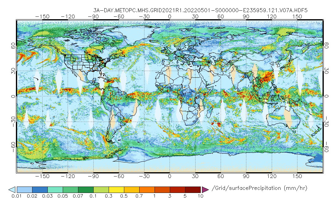
GPM MHS on METOP-C (GPROF) Radiometer Precipitation Profiling L3 1 day 0.25 degree x 0.25 degree V07 (GPM_3GPROFMETOPCMHS_DAY) at GES DISC recent views
National Aeronautics and Space Administration —
Version 07 is the current version of the data set. 3GPROF products provide global gridded monthly/daily precipitation averages from multiple satellites that can be... -
Federal
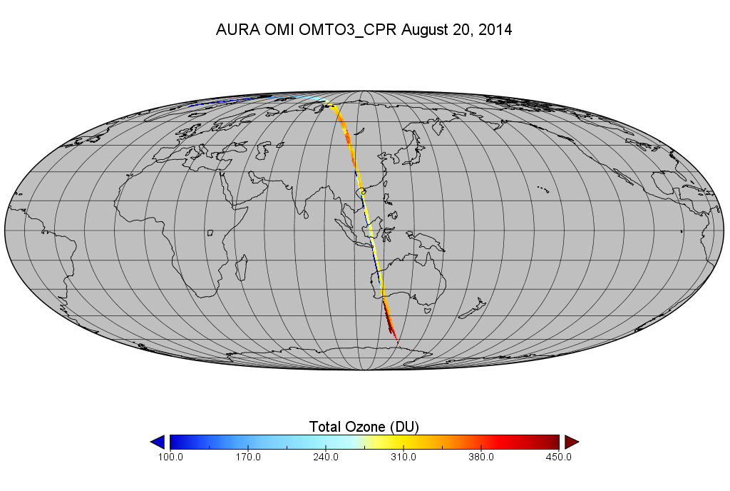
OMI/Aura Level 2 Ozone (O3) Total Column 1-Orbit Subset and Collocated Swath along CloudSat track 200-km wide at 13x24 km2 resolution recent views
National Aeronautics and Space Administration —
This is a CloudSat-collocated subset of the original product OMTO3, for the purposes of the A-Train mission. The goal of the subset is to select and return OMI data... -
Federal
OCO-2 Level 2 spatially ordered geolocated retrievals screened using the A-band Preprocessor, Retrospective Processing V10r (OCO2_L2_ABand) at GES DISC recent views
National Aeronautics and Space Administration —
Version 10r is the current version of the data set. Older versions will no longer be available and are superseded by Version 10r. In early 2021, the OCO Team... -
Federal
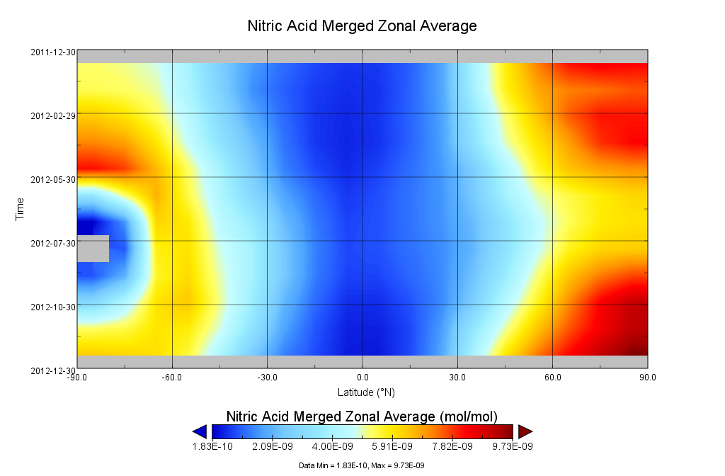
GOZCARDS Merged Nitric Acid 1 month L3 10 degree Zonal Means on a Vertical Pressure Grid V1 (GozMmlpHNO3) at GES DISC recent views
National Aeronautics and Space Administration —
The GOZCARDS Merged Data for Nitric Acid 1 month L3 10 degree Zonal Averages on a Vertical Pressure Grid product (GozMmlpHNO3) contains zonal means and related... -
Federal
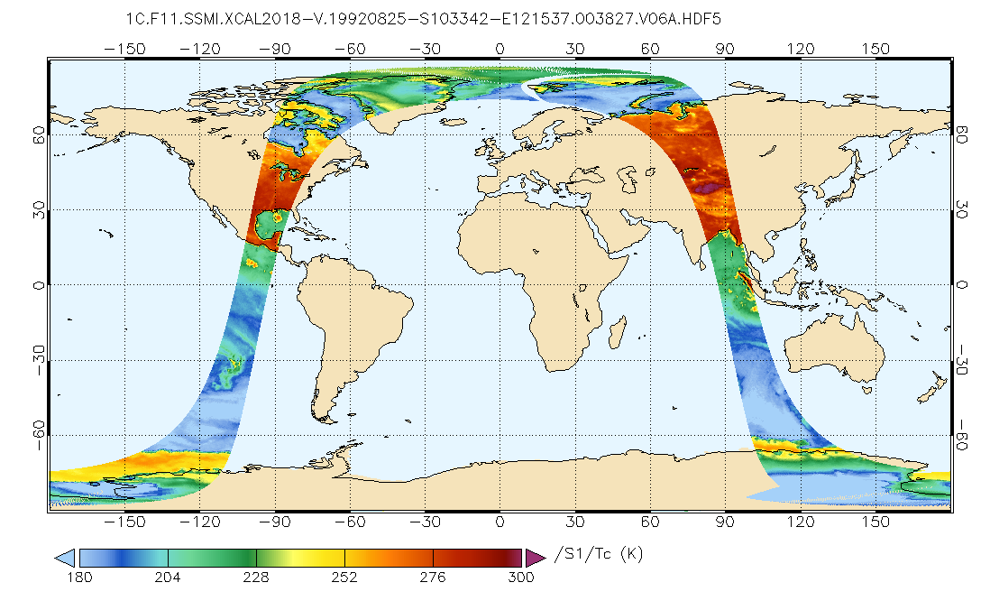
GPM SSMI on F11 Common Calibrated Brightness Temperatures L1C 1.5 hours 13 km V07 (GPM_1CF11SSMI) at GES DISC recent views
National Aeronautics and Space Administration —
All 1C products have a common L1C data structure, simple and generic. Each L1C swath includes scan time, latitude and longitude, scan status, quality, incidence... -
Federal
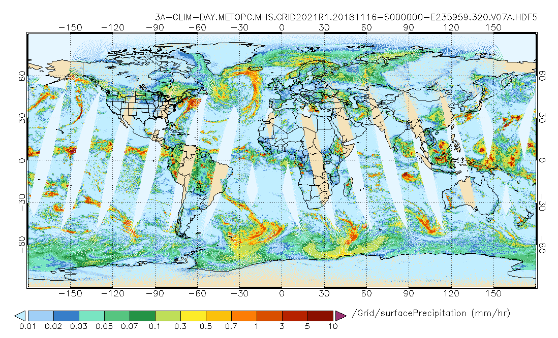
GPM MHS on METOP-C (GPROF) Climate-based Radiometer Precipitation Profiling L3 1 day 0.25 degree x 0.25 degree V07 (GPM_3GPROFMETOPCMHS_DAY_CLIM) at GES DISC recent views
National Aeronautics and Space Administration —
Version 07 is the current version of the data set. Older versions are no longer available and have been superseded by Version 07. The "CLIM" products differ from... -
Federal
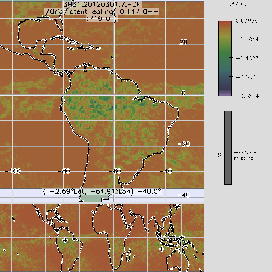
TRMM TMI/PR Combined Convective Stratiform Heating L3 1 month 0.5 degree x 0.5 degree V7 (TRMM_3H31) at GES DISC recent views
National Aeronautics and Space Administration —
3H31, "Monthly Convective Stratiform Heating from Combined", produces 0.5 deg x 0.5 deg monthly apparent heating profiles from surface convective rainfall rate and... -
Federal
ATMOS L2 Trace Gases on Potential Temperature Grid, Tab Delimited Format V3 (ATMOSL2TT) at GES DISC recent views
National Aeronautics and Space Administration —
This is the version 3 Atmospheric Trace Molecule Spectroscopy (ATMOS) Level 2 product containing trace gases on a vertical potential temperature (theta) grid with... -
Federal
MLS/Aura Level 3 Daily Binned Nitric Acid (HNO3) Mixing Ratio on Zonal and Similar Grids V005 (ML3DZHNO3) at GES DISC recent views
National Aeronautics and Space Administration —
ML3DZHNO3 is the EOS Aura Microwave Limb Sounder (MLS) daily binned on zonal and assorted vertical grids product for nitric acid (HNO3) derived from radiances... -
Federal
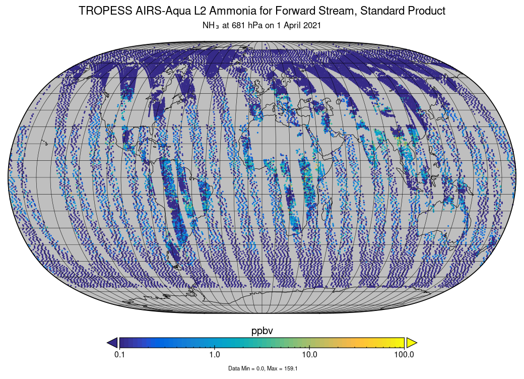
TROPESS AIRS-Aqua L2 Ammonia for Forward Stream, Standard Product V1 (TRPSDL2NH3AIRSFS) at GES DISC recent views
National Aeronautics and Space Administration —
The TROPESS AIRS-Aqua L2 Ammonia for Forward Stream, Standard Product contains the vertical distribution of the retrieved atmospheric state of ammonia (NH3), formal... -
Federal
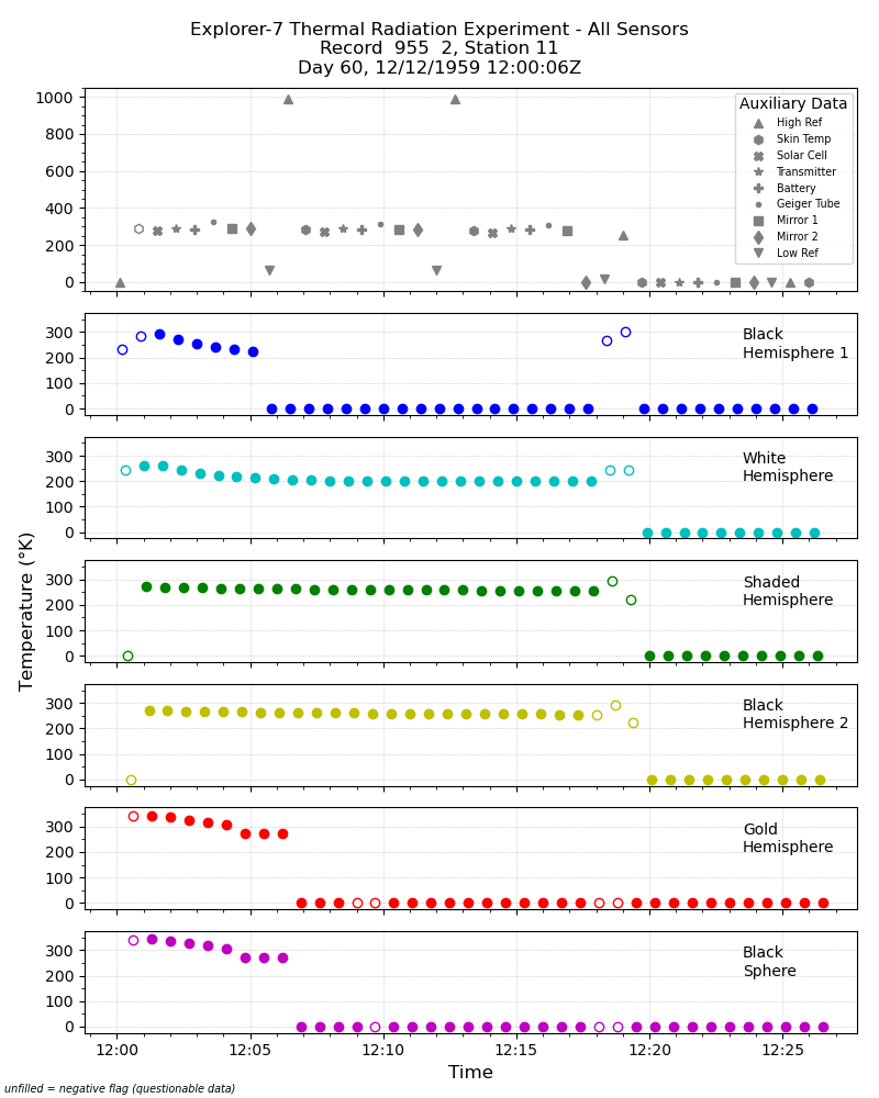
Explorer-7 Thermal Radiation Experiment Temperature Values from All Sensors V001 (EXP7L1TRTALL) at GES DISC recent views
National Aeronautics and Space Administration —
Explorer-7 Thermal Radiation Experiment Temperature Values from All Sensors product contains temperature readings from all five bolometers in order to measure solar,... -
Federal
MERRA-2 tavgU_2d_glc_Nx: 2d,diurnal,Time-Averaged,Single-Level,Assimilation,Land Ice Surface Diagnostics 0.625 x 0.5 degree V5.12.4 (M2TUNXGLC) at GES DISC recent views
National Aeronautics and Space Administration —
M2TUNXGLC (or tavgU_2d_glc_Nx) is a 2-dimensional monthly diurnal means data collection in Modern-Era Retrospective analysis for Research and Applications version 2... -
Federal
MERRA-2 tavg3_3d_rad_Nv: 3d,3-Hourly,Time-Averaged,Model-Level,Assimilation,Radiation Diagnostics 0.625 x 0.5 degree V5.12.4 (M2T3NVRAD) at GES DISC recent views
National Aeronautics and Space Administration —
M2T3NVRAD (or tavg3_3d_rad_Nv) is a 3-dimensional 3-hourly time averaged data collection in Modern-Era Retrospective analysis for Research and Applications version 2... -
Federal
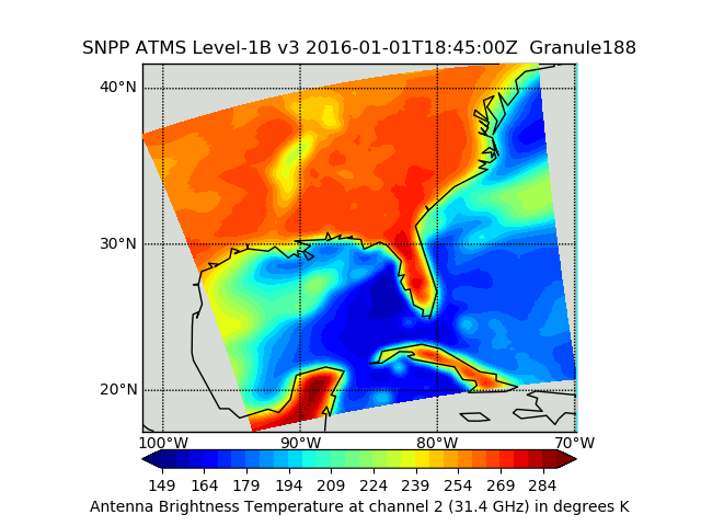
Suomi NPP ATMS Sounder Science Investigator-led Processing System (SIPS) Level 1B Brightness Temperature V3 (SNPPATMSL1B) at GES DISC recent views
National Aeronautics and Space Administration —
The Advanced Technology Microwave Sounder (ATMS) Level 1B data files contain brightness temperature measurements along with ancillary spacecraft, instrument, and... -
Federal
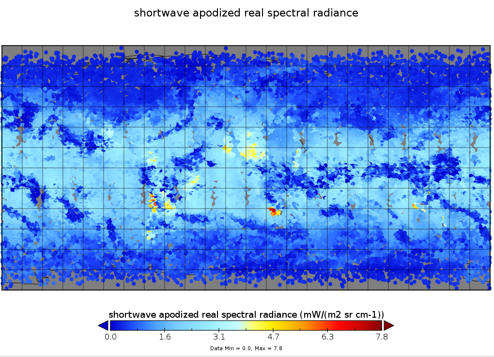
Sounder SIPS: Suomi NPP CrIS Level-1B NSR Calibration Subset: Random full spectra V2 (SNDRSNIL1BCALSUBRNDN) at GES DISC recent views
National Aeronautics and Space Administration —
The CrIS/ATMS instruments used for this product are on board the Suomi National Polar-orbiting Partnership (SNPP) platform and use the Normal Spectral Resolution...

Official websites use .gov
A
.gov website belongs to an official government
organization in the United States.
Secure .gov websites use HTTPS
A
lock (
) or https:// means you’ve safely connected to
the .gov website. Share sensitive information only on official,
secure websites.