
-
Federal
GPM GROUND VALIDATION DUAL-FREQUENCY DUAL-POLARIZED DOPPLER RADAR (D3R) GCPEX V1 recent views
National Aeronautics and Space Administration —
The GPM Ground Validation Dual-frequency Dual-polarized Doppler Radar (D3R) GCPEx and IFloodS data sets contain radar reflectivity and doppler velocity measurements.... -
Federal
VIIRS/SNPP Deep Blue Level 3 daily aerosol data, 1 degree x 1 degree grid recent views
National Aeronautics and Space Administration —
The VIIRS/SNPP Deep Blue Level 3 daily aerosol data, 1x1 degree grid, Short-name AERDB_D3_VIIRS_SNPP product is derived from the Version-2.0 (V2.0) L2 6-minute swath-... -
Federal
Site Averaged Flux Data: 1988 (Betts) recent views
National Aeronautics and Space Administration —
Site averaged product of the flux data collected by many PIs during the 1987-1989 FIFE experiment. Data are in 30-minute intervals and include data only for 1988. -
Federal
TROPESS Chemical Reanalysis Surface CO 2-Hourly 2-dimensional Product V1 (TRPSCRCO2H2D) at GES DISC recent views
National Aeronautics and Space Administration —
The TROPESS Chemical Reanalysis CO 2-Hourly 2-dimensional Product contains the surface concentrations of carbon monoxide. The data are part of the Tropospheric... -
Federal
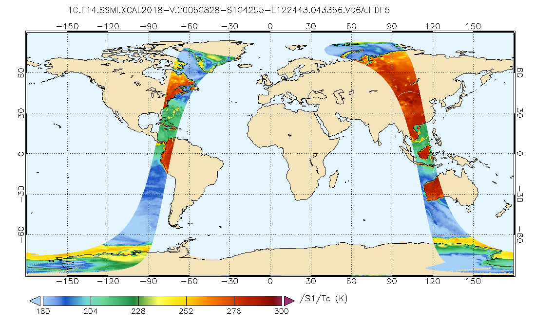
GPM SSMI on F14 Common Calibrated Brightness Temperatures L1C 1.5 hours 13 km V07 (GPM_1CF14SSMI) at GES DISC recent views
National Aeronautics and Space Administration —
All 1C products have a common L1C data structure, simple and generic. Each L1C swath includes scan time, latitude and longitude, scan status, quality, incidence... -
Federal
SAFARI 2000 FPAR TRAC Data for Mongu, Zambia, 1999-2002 recent views
National Aeronautics and Space Administration —
Data from the Tracing Architecture and Radiation of Canopies (TRAC) instrument were processed to determine the fraction of intercepted photosynthetically active... -
Federal
VIIRS/NOAA20 Cloud Properties 6-min L2 Swath 750m recent views
National Aeronautics and Space Administration —
The VIIRS/NOAA20 Cloud Properties 6-min L2 Swath 750m product is a continuity product similar to its counterpart product from the Suomi National Polar-orbiting... -
Federal
MODIS (Aqua/Terra) Cloud Properties Level 3 monthly, 1x1 degree grid NGDA recent views
National Aeronautics and Space Administration —
The combined MODIS (Aqua/Terra) Cloud Properties Level 3 monthly, 1x1 degree grid product represents a new addition that is especially geared to facilitate climate... -
Federal
MODIS/Aqua Aerosol Cloud Water Vapor Ozone 8-Day L3 Global 1Deg CMG NGDA recent views
National Aeronautics and Space Administration —
The MODIS/Aqua Aerosol Cloud Water Vapor Ozone 8-Day L3 Global 1Deg CMG product (MYD08_E3) contains 8-Day 1 degree x 1 degree grid average values of atmospheric... -
Federal
VIIRS/SNPP Cloud Properties COSP Level 3 daily, 1x1 deg. grid recent views
National Aeronautics and Space Administration —
The VIIRS/SNPP Cloud Properties COSP Level 3 daily, 1x1 degree grid product is a new L3 CLDPROP COSP Cloud product with short-name CLDPROPCOSP_D3_VIIRS_SNPP. It... -
Federal
Fast Longwave And SHortwave Fluxes (FLASHflux) NOAA-20 Clouds and Radiative Swath (SSF) Version1B recent views
National Aeronautics and Space Administration —
FLASH_SSF_NOAA20-FM6-VIIRS_Version1B data are near real-time CERES observed TOA fluxes, clouds, and parameterized surface fluxes, not officially calibrated. The Fast... -
Federal
VIIRS/NOAA20 Deep Blue Level 3 daily aerosol data, 1 degree x 1 degree grid recent views
National Aeronautics and Space Administration —
The VIIRS/NOAA20 Deep Blue Level 3 daily aerosol data, 1x1 degree grid, Short-name AERDB_D3_VIIRS_NOAA20 product is derived from the Version-2.0 (V2.0) L2 6-minute... -
Federal
AIRS/Aqua L3 5-day Quantization in Physical Units (AIRS-only) 5 degrees x 5 degrees V006 (AIRS3QP5) at GES DISC recent views
National Aeronautics and Space Administration —
The Atmospheric Infrared Sounder (AIRS) is a grating spectrometer (R = 1200) aboard the second Earth Observing System (EOS) polar-orbiting platform, EOS Aqua. In... -
Federal
ECOSTRESS Tiled Downscaled Meteorology Instantaneous L3 Global 70 m V002 recent views
National Aeronautics and Space Administration —
The ECOsystem Spaceborne Thermal Radiometer Experiment on Space Station (ECOSTRESS) mission measures the temperature of plants to better understand how much water... -
Federal
VIIRS/NOAA20 Cloud Properties COSP Level 3 daily, 1x1 deg. grid recent views
National Aeronautics and Space Administration —
The VIIRS/NOAA20 Cloud Properties COSP Level 3 daily, 1x1 degree grid product is a new L3 CLDPROP COSP Cloud product with short-name CLDPROPCOSP_D3_VIIRS_NOAA20. It... -
Federal
AIRS/Aqua L3 8-day Support Product (AIRS-only) 1 degree X 1 degree V006 (AIRS3SP8) at GES DISC recent views
National Aeronautics and Space Administration —
The Atmospheric Infrared Sounder (AIRS) is a grating spectrometer (R = 1200) aboard the second Earth Observing System (EOS) polar-orbiting platform, EOS Aqua. In... -
Federal
Bowen Ratio Surface Flux: KSU (FIFE) recent views
National Aeronautics and Space Administration —
Assessing the effects of annual burning & topography on surface energy exchanges -
Federal
MODIS/Aqua Dark Target Aerosol 5-Min L2 Swath 10 km NGDA recent views
National Aeronautics and Space Administration —
The MODIS/Aqua Dark Target Aerosol 5-Min L2 Swath 10 km product, short-name XAERDT_L2_MODIS_Aqua is provided at 10-km spatial resolution (at-nadir) and a 5-minute... -
Federal
MODIS/Terra Dark Target Aerosol 5-Min L2 Swath 10 km NGDA recent views
National Aeronautics and Space Administration —
The MODIS/Terra Dark Target Aerosol 5-Min L2 Swath 10 km product, short-name XAERDT_L2_MODIS_Terra is provided at 10-km spatial resolution (at-nadir) and a 5-minute... -
Federal
VIIRS/SNPP Dark Target Aerosol L2 6-Min Swath 6km recent views
National Aeronautics and Space Administration —
The SNPP/VIIRS L2 Dark Target Aerosol 6-Min L2 Swath 6 km product, short-name XAERDT_L2_VIIRS_SNPP is provided at 6-km spatial resolution (at-nadir) and a 6-minute...

Official websites use .gov
A
.gov website belongs to an official government
organization in the United States.
Secure .gov websites use HTTPS
A
lock (
) or https:// means you’ve safely connected to
the .gov website. Share sensitive information only on official,
secure websites.