

356 datasets found for "Ozone"
-
Air Quality Clarity Node Sensors
District of Columbia —
This dataset is made up of hourly measurements of PM2.5 and PM10, and meteorological measurements, collected through DOEE’s Clarity Node network in the District of... -
Federal
Aqua MODIS Global Mapped Photosynthetically Available Radiation (PAR) - Near Real Time (NRT) Data, version R2022.0 NGDA
National Aeronautics and Space Administration —
The Ocean Biology DAAC produces near real-time (quicklook) products using the best-available combination of ancillary data from meteorological and ozone data. As... -
Federal
NOAA/WDS Paleoclimatology - Wager - Millcreek Mouth - PSME - ITRDB UT574
National Oceanic and Atmospheric Administration, Department of Commerce —
This archived Paleoclimatology Study is available from the NOAA National Centers for Environmental Information (NCEI), under the World Data Service (WDS) for... -
Federal
NOAA/WDS Paleoclimatology - Wager - Millcreek Bowman Fork - PSME - ITRDB UT572
National Oceanic and Atmospheric Administration, Department of Commerce —
This archived Paleoclimatology Study is available from the NOAA National Centers for Environmental Information (NCEI), under the World Data Service (WDS) for... -
Federal
Terra MODIS Level-3 Global Mapped 4µm Day/Night Sea Surface Temperature (SST4) - Near Real-time (NRT) Data, version R2019.0 NGDA
National Aeronautics and Space Administration —
The Ocean Biology DAAC produces near real-time (quicklook) products using the best-available combination of ancillary data from meteorological and ozone data. As... -
Federal
Sounder SIPS: AQUA AIRS IR + MW Level 2 CLIMCAPS: Cloud Cleared Radiances V2 at GES DISC
National Aeronautics and Space Administration —
The CLIMCAPS (Community Long-term Infrared Microwave Coupled Product System) algorithm is used to analyze data from the AIRS (Atmospheric Infrared Sounder) and AMSU... -
Federal
Terrestrial Condition Assessment (TCA) Ozone - Chronic
Department of Agriculture —
Direct Download (Raster Data Gateway)Objective: Assess impacts to vegetation from acute exposure to ozone (O3) during the growing season (April to September).Data:... -
Federal
NOAA-20 VIIRS Level-2 Regional Triple-window Sea Surface Temperature (SST3) - Near Real-time (NRT) Data, version R2024.0
National Aeronautics and Space Administration —
The Ocean Biology DAAC produces near real-time (quicklook) products using the best-available combination of ancillary data from meteorological and ozone data. As... -
Federal
UARS Halogen Occultation Experiment (HALOE) Level 3AT V019 (UARHA3AT) at GES DISC
National Aeronautics and Space Administration —
The Halogen Occultation Experiment (HALOE) Level 3AT data product consists of daily vertical profiles of temperature, aerosol extinction and concentrations of HCl,... -
Federal
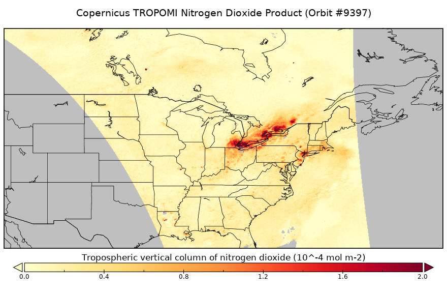
Sentinel-5P TROPOMI Near-Real-Time (NRT) Tropospheric NO2 1-Orbit L2 5.5km x 3.5km V2 (S5P_L2__NO2____HiR_NRT) at GES DISC
National Aeronautics and Space Administration —
The Sentinel-5P TROPOMI Near Real Time (NRT) Tropospheric NO2 1-Orbit L2 5.5km x 3.5km V2 (S5P_L2__NO2_HiRNRT) at GES DISC is the near real time version of the... -
Federal
NOAA-20 VIIRS Global Mapped Inherent Optical Properties (IOP) - Near Real-time (NRT) Data, version R2022.0
National Aeronautics and Space Administration —
The Ocean Biology DAAC produces near real-time (quicklook) products using the best-available combination of ancillary data from meteorological and ozone data. As... -
Federal
Aqua MODIS Regional Ocean Color (OC) - Near Real Time (NRT) Data, version R2022.0 NGDA
National Aeronautics and Space Administration —
The Ocean Biology DAAC produces near real-time (quicklook) products using the best-available combination of ancillary data from meteorological and ozone data. As... -
Federal
Sentinel-3A OLCI Level-2 Regional Earth-observation Full Resolution (EFR) Inherent Optical Properties (IOP) - Near Real-time (NRT) Data, version R2022.0
National Aeronautics and Space Administration —
The Ocean Biology DAAC produces near real-time (quicklook) products using the best-available combination of ancillary data from meteorological and ozone data. As... -
Federal
Terra MODIS Global Mapped Fluorescence Line Height (FLH) - Near Real Time (NRT) Data, version R2022.0 NGDA
National Aeronautics and Space Administration —
The Ocean Biology DAAC produces near real-time (quicklook) products using the best-available combination of ancillary data from meteorological and ozone data. As... -
Federal
The Lethality of Hot Water, Chlorine, and Ozone on Aquatic Invasive Species
Department of the Interior —
This data describes the use of hot water, chlorine, and ozone as a potential lock treatment to prevent the spread of Aquatic Invasive Species (AIS) during boat... -
Federal
Airborne Volcanic Gas Measurements at Iliamna Volcano, Alaska 2004-2017
Department of the Interior —
This release presents data collected during airborne volcanic gas monitoring flights at Iliamna Volcano, Alaska, that were completed between 2004-2017. Instrumented...
356 datasets found for "Ozone"