
-
Federal
National Agriculture Imagery Program (NAIP) Imagery NGDA
Department of Agriculture —
The National Agriculture Imagery Program (NAIP) is administered by the U.S. Department of Agriculture's Farm Production and Conservation Business Center (FPAC-BC)... -
Federal
National Agriculture Imagery Program (NAIP)
National Aeronautics and Space Administration —
The National Agriculture Imagery Program (NAIP) acquires aerial imagery during the agricultural growing seasons in the continental U.S. A primary goal of the NAIP... -
Federal
U.S. Monthly Climate Normals (1981-2010)
National Oceanic and Atmospheric Administration, Department of Commerce —
The U.S. Monthly Climate Normals for 1981 to 2010 are 30-year averages of meteorological parameters for thousands of U.S. stations located across the 50 states, as... -
Federal
US Forest Atlas FIA Modeled Abundance, Forest-type Groups, Harvest and Carbon (Rest Services Directory)
Department of Agriculture —
FIA Modeled Abundance:�This dataset portrays the live tree mean basal area (square feet per acre) of the species across the contiguous United States. The underlying... -
Federal
U.S. Climate Normals 2020: U.S. Annual/Seasonal Climate Normals (1991-2020)
National Oceanic and Atmospheric Administration, Department of Commerce —
The U.S. Annual/Seasonal Climate Normals for 1991 to 2020 are 30-year averages of meteorological parameters that provide users the information needed to understand... -
Federal
Lidar point clouds (LPC), elevation models, GPS data, image mosaics, and aerial images from thermal infra-red (TIR), natural color (RGB), and multispectral cameras collected during UAS operations at Lower Darby Creek, Darby Township, Pennsylvania, August 14, 2024
Department of the Interior —
The U.S. Geological Survey deployed small uncrewed aircraft systems (sUAS) to collect aerial remote sensing data across sites within the Lower Darby Creek Superfund... -
Federal
Klamath Basin Restoration Agreement Off-Project Water Program Evapotranspiration Map for May 2004
Department of the Interior —
Hydrological Information Products for the Off-Project Water Program of the Klamath Basin Restoration Agreement U.S. Geological Survey Open-File Report 2012-1199 U.S.... -
Federal
Cladophora biomass and supporting data collected in the Great Lakes, 2021
Department of the Interior —
This dataset records Cladophora and associated benthic algae, collectively Cladophora community or submerged aquatic vegetation (SAV), biomass collected during the... -
State
Soils Hydric Rating
State of Connecticut —
This rating indicates the percentage of map units that meets the criteria for hydric soils. Map units are composed of one or more map unit components or soil types,... -
Federal
EnviroAtlas - Agricultural Water Demand by 12-Digit HUC for the Conterminous United States
U.S. Environmental Protection Agency —
The national agricultural water demand metric provides insight into the amount of water used for agricultural irrigation in the contiguous United States. The... -
Federal
Climate Change Pressures Growing Degree Days (Map Service)
Department of Agriculture —
Evaluating multiple signals of climate change across the conterminous United States during three 30-year periods (2010�2039, 2040�2069, 2070�2099) during this century... -
Federal
GIS shapefile: Charlotte County, Florida irrigated agricultural land-use for the 2018 growing season (ver. 1.1, May 2019)
Department of the Interior —
This data set consists of a detailed digital map of the areal extent of fields and a summary of the irrigated acreage for the 2018 growing season developed for... -
Federal
Larval lake whitefish diets in western Lake Erie during 2018, 2019, and 2021
Department of the Interior —
Recent declines in Lake Whitefish population abundance has prompted research to identify underlying mechanisms controlling survival of early life stages in the Great... -
Federal
GIS shapefile: Okeechobee County, Florida irrigated agricultural land-use GIS shapefile for the 2017 growing season
Department of the Interior —
This data set consists of a detailed digital map of individual irrigated fields and a summary of the irrigated acreage for the 2017 growing season developed for... -
Federal
Geospatial Dataset of Agricultural Lands in the Upper Colorado River Basin, 2007 - 10
Department of the Interior —
This dataset represents the extent and spatial distribution of irrigated agricultural lands in the Upper Colorado River Basin for 2007-10. The boundaries in this... -
Federal
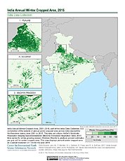
India Annual Winter Cropped Area, 2001-2016 NGDA
National Aeronautics and Space Administration —
The India Annual Winter Cropped Area, 2001 - 2016 consists of annual winter cropped areas for most of India (except the Northeastern states) from 2000-2001 to... -
Federal
Number of Frost-Free Days (Map Service)
Department of Agriculture —
Date of freeze for historical (1985-2005) and future (2071-2090, RCP 8.5) time periods, and absolute change between them, based on analysis of MACAv2METDATA. Download... -
Federal
MDDNR, Station Dares Beach
National Oceanic and Atmospheric Administration, Department of Commerce —
At continuous monitoring sites throughout Maryland, water quality is monitored at shallow water sites located in Chesapeake Bay, Chesapeake Bay tributaries and... -
Federal
MDDNR, Station Public Landing
National Oceanic and Atmospheric Administration, Department of Commerce —
At continuous monitoring sites throughout Maryland, water quality is monitored at shallow water sites located in Chesapeake Bay, Chesapeake Bay tributaries and... -
Federal
Estimated crop irrigation water use withdrawals in Harquahala Irrigation Non-Expansion Area Groundwater Basin, Arizona for 2023
Department of the Interior —
Observations of irrigated agricultural land within the Harquahala Irrigation Non-Expansion Area Groundwater Basin in Arizona. Crops were verified in situ three times...

Official websites use .gov
A
.gov website belongs to an official government
organization in the United States.
Secure .gov websites use HTTPS
A
lock (
) or https:// means you’ve safely connected to
the .gov website. Share sensitive information only on official,
secure websites.