
-
Federal
LBA-ECO ND-02 Agricultural and Secondary Forest Soil Trace Gas Flux, Para: 2001-2004
National Aeronautics and Space Administration —
This data set reports the results of a study to measure soil emissions of the carbon dioxide (CO2), methane (CH4), and nitrous oxide (N2O), and nitric oxide (NO)... -
Federal
WLDAS Noah-MP 3.6 Land Surface Model L4 Daily 0.01 degree x 0.01 degree Version D1.0 (WLDAS_NOAHMP001_DA1) at GES DISC
National Aeronautics and Space Administration —
The Western Land Data Assimilation System (WLDAS), developed at Goddard Space Flight Center (GSFC) and funded by the NASA Western Water Applications Office, provides... -
Federal
MERRA-2 tavgU_2d_lnd_Nx: 2d,diurnal,Time-Averaged,Single-Level,Assimilation,Land Surface Diagnostics 0.625 x 0.5 degree V5.12.4 (M2TUNXLND) at GES DISC
National Aeronautics and Space Administration —
M2TUNXLND (or tavgU_2d_lnd_Nx) is a time-averaged 2-dimensional monthly diurnal means data collection in Modern-Era Retrospective analysis for Research and... -
Federal
Bowen Ratio Surface Flux: UNL (FIFE)
National Aeronautics and Space Administration —
Latent & sensible heat flux by Bowen Ratio & aerodynamic characterization of vegetation -
Federal
LBA-ECO CD-05 Understory Fuel Stick Moisture, km 67 Site, Para, Brazil: 1998-2000
National Aeronautics and Space Administration —
This data set contains moisture content measurements for fuel sticks located in the forest understory of the rainfall exclusion experimental site, Tapajos National... -
Federal
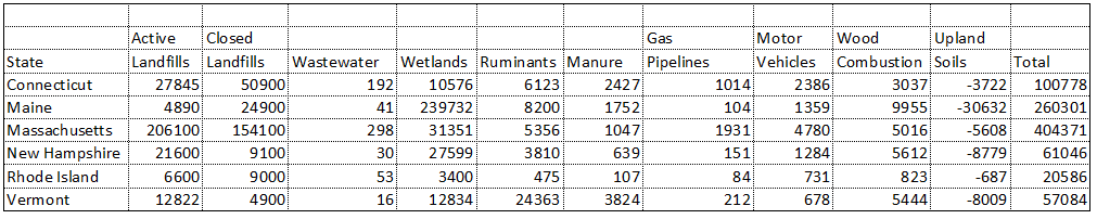
Natural and Anthropogenic Methane Sources, New England, USA, 1990-1994
National Aeronautics and Space Administration —
This data set contains an inventory of natural and anthropogenic methane emissions for all counties in the six New England states of Connecticut, Rhode Island,... -
Federal
NPP Multi-Biome: Summary Data from Intensive Studies at 125 Sites, 1936-2006
National Aeronautics and Space Administration —
This data set, NPP Multi-Biome: Summary Data from Intensive Studies at 125 Sites, 1936-2006, contains a single shapefile that provides site-level summary statistics... -
Federal
LBA-ECO TG-05 NPP, Carbon Pool, Soil Characteristics, Soil Gas Flux Maps of Brazil
National Aeronautics and Space Administration —
This data set provides maps produced from model output data from the National Aeronautics and Space Administration-Carnegie Ames Stanford Approach (NASA-CASA) model... -
Federal
BOREAS TGB-07 Rainwater Herbicide and Organochlorine Concentration Data
National Aeronautics and Space Administration —
Contains 1993 and 1994 herbicide concentrations in rain samples for TGB-07 in the SSA. -
Federal
BOREAS TF-01 SSA-OA Understory Flux, Meteorological, and Soil Temperature Data
National Aeronautics and Space Administration —
Energy, carbon dioxide, and momentum flux data collected under the canopy along with meteorological and soils data at the BOREAS SSA-OA site from mid-October to mid-... -
Federal
ABoVE: Environmental Conditions During Fall Moose Hunting Seasons, Alaska, 2000-2016 NGDA
National Aeronautics and Space Administration —
This dataset provides daily and annual air temperature, river water level, and leaf drop dates coincident with the moose (Alces alces) hunting season (September) for... -
Federal
CMS: Global Carbon Fluxes Associated with Livestock Feed and Emissions, 2000-2013
National Aeronautics and Space Administration —
This data set provides global annual carbon flux estimates, at 0.05-degree resolution, associated with livestock feed intake, manure, manure management, respiration,... -
Federal
LBA-ECO CD-05 Forest Understory Fuel Loads, Paragominas, Para, Brazil: 2001
National Aeronautics and Space Administration —
This data set contains estimates of understory fuel loads (forest litter) at six locations near Paragominas in Northeastern Amazonia. Samples were collected from... -
Federal
Geoecology: County-Level Environmental Data for the United States, 1941-1981
National Aeronautics and Space Administration —
The Geoecology database is a compilation of environmental data for the period 1941 to 1981. The Geoecology database contains selected data on terrain and soils, water... -
Federal
Site Averaged Flux Data: 1987-1989 (Betts)
National Aeronautics and Space Administration —
Site averaged product of the flux data collected by many PIs during the 1987-1989 FIFE experiment. Data are in 30-minute intervals and include the entire period... -
Federal
ABoVE: Wildfire Carbon Emissions and Burned Plot Characteristics, NWT, CA, 2014-2016
National Aeronautics and Space Administration —
This dataset provides estimates of wildfire carbon emissions and uncertainties at 30-m resolution, and measurements collected at burned and unburned field plots from... -
Federal
Global N Cycle: Fluxes and N2O Mixing Ratios Originating from Human Activity
National Aeronautics and Space Administration —
Nitrogen is a major nutrient in terrestrial ecosystems and an important catalyst in tropospheric photochemistry. Over the last century human activities have... -
Federal
NACP Regional: Gridded 1-deg Observation Data and Biosphere and Inverse Model Outputs NGDA
National Aeronautics and Space Administration —
This data set contains standardized gridded observation data, terrestrial biosphere model output data, and inverse model simulations of carbon flux parameters that... -
Federal
Annual wildland fire emissions (WFEIS v0.5) for Conterminous US and Alaska, 2001-2013 NGDA
National Aeronautics and Space Administration —
This data set contains annual modeled estimates of wildland fire emissions at 0.01 degree (~1-km) spatial resolution from the Wildland Fire Emissions Information... -
Federal
CMS: Carbon Fluxes from Global Agricultural Production and Consumption, 2005-2011
National Aeronautics and Space Administration —
This data set provides global estimates of carbon fluxes associate with annual crop net primary production (NPP) and harvested biomass, annual uptake and release by...

Official websites use .gov
A
.gov website belongs to an official government
organization in the United States.
Secure .gov websites use HTTPS
A
lock (
) or https:// means you’ve safely connected to
the .gov website. Share sensitive information only on official,
secure websites.