
-
Federal
Surface-water temperature, salinity, pH, dissolved oxygen, and turbidity data from nearshore coral reef locations along the west coast of Hawaii Island (2010-2013)
Department of the Interior —
Spatial measurements of water temperature, specific conductance, salinity, pH, dissolved oxygen, and turbidity between 0.25 and 0.50 m water depth were collected... -
Federal
Sea level measured by tide gauges from global oceans as part of the Joint Archive for Sea Level (JASL) since 1846
National Oceanic and Atmospheric Administration, Department of Commerce —
This collection contains the complete holdings of the Joint Archive for Sea Level (JASL) for hourly and daily data that have been quality controlled, assessed, and... -
Federal
Apache Pier
National Oceanic and Atmospheric Administration, Department of Commerce —
Timeseries data from 'Apache Pier' (apache-pier) -
Federal
Surface ocean radial velocities obtained by HF-radar from stations located along coastal waters of Hawaii, North Slope Alaska, Gulf of Alaska, Puerto Rico/Virgin Islands, eastern U.S./Gulf of America, western U.S., and the Great Lakes
National Oceanic and Atmospheric Administration, Department of Commerce —
This dataset contains surface ocean radial velocities data obtained by HF-radar from stations located along coastal waters of the United States. Radial velocity files... -
Federal
Summary of recreational hook and line caught sea turtles documented by the NOAA Galveston Laboratory
National Oceanic and Atmospheric Administration, Department of Commerce —
The database is a summary of sea turtles that are hook and line captured by recreational anglers in the region covered by the NOAA Galveston Laboratory through its... -
Federal
Physical, meteorological, and biological data collected from non-federal stations assembled by the Northwest Association of Networked Ocean Observing Systems (NANOOS)
National Oceanic and Atmospheric Administration, Department of Commerce —
This dataset contains physical, meteorological and geochemical data, collected at moorings located in Puget Sound, WA and along the Washington and Oregon coasts. The... -
Federal
Mean high water (MHW) shorelines along the coast of California used to calculated shoreline change from 1998 to 2016
Department of the Interior —
This dataset contains mean high water (MHW) shorelines for sandy beaches along the coast of California for the years 1998/2002, 2015, and 2016. The MHW elevation in... -
Federal
Non-commercial Boat-based Line Fishing Estimated Average Annual Catch of Reef Fish, 2004-2013 - Hawaii
National Oceanic and Atmospheric Administration, Department of Commerce —
Nearshore fisheries in the Main Hawaiian Islands encompass a diverse group of fishers using a wide array of gears and targeting many different species. Communities in... -
Federal
H13092: NOS Hydrographic Survey , 2017-11-09
National Oceanic and Atmospheric Administration, Department of Commerce —
The National Oceanic and Atmospheric Administration (NOAA) has the statutory mandate to collect hydrographic data in support of nautical chart compilation for safe... -
Federal
Oceanographic data collected from non-federal stations assembled by the Great Lakes Observing System (GLOS)
National Oceanic and Atmospheric Administration, Department of Commerce —
This dataset contains oceanographic and surface meteorological data collected from non-Federal stations throughout the Great Lakes region of the United States. The... -
Federal
CalHABMAP - HABs Morro Bay Front Bay data
National Oceanic and Atmospheric Administration, Department of Commerce —
The California Harmful Algal Bloom Monitoring and Alert Program (CalHABMAP) collects weekly phytoplankton and water quality data at eight piers along the Central and... -
Federal
F00789: NOS Hydrographic Survey , 2019-10-25
National Oceanic and Atmospheric Administration, Department of Commerce —
The National Oceanic and Atmospheric Administration (NOAA) has the statutory mandate to collect hydrographic data in support of nautical chart compilation for safe... -
Federal
F00775: NOS Hydrographic Survey , 2019-06-04
National Oceanic and Atmospheric Administration, Department of Commerce —
The National Oceanic and Atmospheric Administration (NOAA) has the statutory mandate to collect hydrographic data in support of nautical chart compilation for safe... -
Federal
SeaBASS Bio-optical and pigment data collected from 1979-08-22 to 2011-12-14 (NCEI Accession 0086308)
National Oceanic and Atmospheric Administration, Department of Commerce —
This dataset contains SeaWiFS Bio-optical Archive and Storage System (SeaBASS) bio-optical, pigment, and other data collected from 1979-08-22 to 2011-12-14. Archived... -
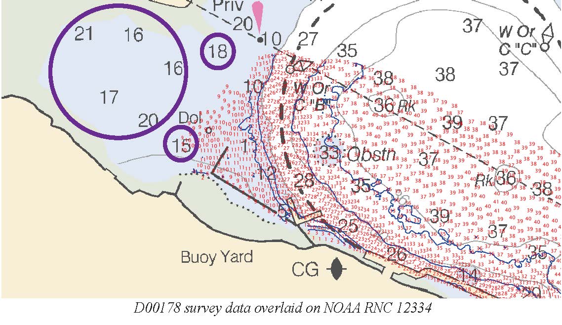
Federal
D00178: NOS Hydrographic Survey , 2013-04-29
National Oceanic and Atmospheric Administration, Department of Commerce —
The National Oceanic and Atmospheric Administration (NOAA) has the statutory mandate to collect hydrographic data in support of nautical chart compilation for safe... -
Federal
Raw continuous resistivity profile data collected by the U.S. Geological Survey in Great South Bay on Long Island, New York, on May 20, 2008
Department of the Interior —
An investigation of submarine aquifers adjacent to the Fire Island National Seashore and Long Island, New York, was conducted to assess the importance of submarine... -
Federal
Assessment of invasiveness of the Orange Keyhole Sponge, Mycale Armata, in Kaneohe Bay Oahu, Hawaii, based on surveys 2004-2005 (NCEI Accession 0002602)
National Oceanic and Atmospheric Administration, Department of Commerce —
The Orange Keyhole Sponge, Mycale armata Thiele, was unknown in Hawaii prior to 1996. First reported in Pearl Harbor, it now occurs in virtually every commercial... -
Federal
PacIOOS Nearshore Sensor 016: Wailupe, Oahu, Hawaii
National Oceanic and Atmospheric Administration, Department of Commerce —
The nearshore sensors are part of the Pacific Islands Ocean Observing System (PacIOOS) and are designed to measure a variety of ocean parameters at fixed points.... -
Federal
RES2DINV format continuous resistivity profile data collected by the U.S. Geological Survey in Great South Bay on Long Island, New York, on May 22, 2008
Department of the Interior —
An investigation of submarine aquifers adjacent to the Fire Island National Seashore and Long Island, New York, was conducted to assess the importance of submarine... -
Federal
H13810: NOS Hydrographic Survey , 2023-10-03
National Oceanic and Atmospheric Administration, Department of Commerce —
The National Oceanic and Atmospheric Administration (NOAA) has the statutory mandate to collect hydrographic data in support of nautical chart compilation for safe...

Official websites use .gov
A
.gov website belongs to an official government
organization in the United States.
Secure .gov websites use HTTPS
A
lock (
) or https:// means you’ve safely connected to
the .gov website. Share sensitive information only on official,
secure websites.