
-
Federal
Shoreline Mapping Program of HEAD OF GREEN BAY TO PESHTIGO POINT, INCLUDING FOX RIVER TO DE PERE, WI, WI1001G-CM-N NGDA recent views
National Oceanic and Atmospheric Administration, Department of Commerce —
These data provide an accurate high-resolution shoreline compiled from imagery of HEAD OF GREEN BAY TO PESHTIGO POINT, INCLUDING FOX RIVER TO DE PERE, WI . This... -
Federal
2016 NOAA NGS Topobathy Lidar: Sugarloaf Key to Big Pine Key, Florida recent views
National Oceanic and Atmospheric Administration, Department of Commerce —
These data were collected by NOAA using a Riegl VQ880G sensor. The data were acquired from October 11, 2016 through October 24, 2016. The data includes topobathy data... -
Federal
NOAA/WDS Paleoclimatology - Grissino-Mayer fire data from La Marchanita - IMPD USLAM001 recent views
National Oceanic and Atmospheric Administration, Department of Commerce —
This archived Paleoclimatology Study is available from the NOAA National Centers for Environmental Information (NCEI), under the World Data Service (WDS) for... -
Federal
H10749A: NOS Hydrographic Survey , Approaches to Port Everglades, Florida, 1998-06-10 recent views
National Oceanic and Atmospheric Administration, Department of Commerce —
The National Oceanic and Atmospheric Administration (NOAA) has the statutory mandate to collect hydrographic data in support of nautical chart compilation for safe... -
Federal
Shoreline Mapping Program of Intracoastal Waterway, Dollar Bay to Johnson Bay, FL, FL1601D-CM-N NGDA recent views
National Oceanic and Atmospheric Administration, Department of Commerce —
These data provide an accurate high-resolution shoreline compiled from imagery of Intracoastal Waterway, Dollar Bay to Johnson Bay, FL . This vector shoreline data is... -
Federal
Shoreline Data Rescue Project of Beaufort Harbor, North Carolina, NC13A03 NGDA recent views
National Oceanic and Atmospheric Administration, Department of Commerce —
These data were automated to provide an accurate high-resolution historical shoreline of Beaufort Harbor, North Carolina suitable as a geographic information system... -
Federal
Shoreline Mapping Program of Little Hickory Island to Doctors Pass, FL, FL1601C-CM-N NGDA recent views
National Oceanic and Atmospheric Administration, Department of Commerce —
These data provide an accurate high-resolution shoreline compiled from imagery of Little Hickory Island to Doctors Pass, FL . This vector shoreline data is based on... -
Federal
Marine Protected Areas (MPA) Inventory 2023-2024 NGDA recent views
National Oceanic and Atmospheric Administration, Department of Commerce —
The NOAA MPA Inventory represents a collection of data compiled from various federal, state, tribal and territorial entities to provide a publicly available source of... -
Federal
Shoreline Data Rescue Project of Everglades City to Venice, CM-7808 NGDA recent views
National Oceanic and Atmospheric Administration, Department of Commerce —
These data were automated to provide an accurate high-resolution historical shoreline of Everglades City to Venice suitable as a geographic information system (GIS)... -
Federal
Shoreline Data Rescue Project of Craney Island, Virginia, EC11B04 NGDA recent views
National Oceanic and Atmospheric Administration, Department of Commerce —
These data were automated to provide an accurate high-resolution historical shoreline of Craney Island, Virginia suitable as a geographic information system (GIS)... -
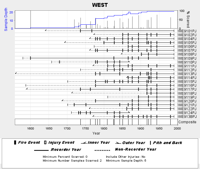
Federal
NOAA/WDS Paleoclimatology - Skinner fire data from WEST (San Pedro Martir) - IMPD MXWES001 recent views
National Oceanic and Atmospheric Administration, Department of Commerce —
This archived Paleoclimatology Study is available from the NOAA National Centers for Environmental Information (NCEI), under the World Data Service (WDS) for... -
Federal
H03223: NOS Hydrographic Survey recent views
National Oceanic and Atmospheric Administration, Department of Commerce —
The National Oceanic and Atmospheric Administration (NOAA) has the statutory mandate to collect hydrographic data in support of nautical chart compilation for safe... -
Federal
H06749: NOS Hydrographic Survey , 1942-09-26 recent views
National Oceanic and Atmospheric Administration, Department of Commerce —
The National Oceanic and Atmospheric Administration (NOAA) has the statutory mandate to collect hydrographic data in support of nautical chart compilation for safe... -
Federal
H05329: NOS Hydrographic Survey , Chesapeake Bay, Maryland, 1933-07-18 recent views
National Oceanic and Atmospheric Administration, Department of Commerce —
The National Oceanic and Atmospheric Administration (NOAA) has the statutory mandate to collect hydrographic data in support of nautical chart compilation for safe... -
Federal
H06397: NOS Hydrographic Survey , 1938-12-31 recent views
National Oceanic and Atmospheric Administration, Department of Commerce —
The National Oceanic and Atmospheric Administration (NOAA) has the statutory mandate to collect hydrographic data in support of nautical chart compilation for safe... -
Federal
H06495: NOS Hydrographic Survey , 1939-12-31 recent views
National Oceanic and Atmospheric Administration, Department of Commerce —
The National Oceanic and Atmospheric Administration (NOAA) has the statutory mandate to collect hydrographic data in support of nautical chart compilation for safe... -
Federal
H07935: NOS Hydrographic Survey , 1951-12-31 recent views
National Oceanic and Atmospheric Administration, Department of Commerce —
The National Oceanic and Atmospheric Administration (NOAA) has the statutory mandate to collect hydrographic data in support of nautical chart compilation for safe... -
Federal
H02153: NOS Hydrographic Survey recent views
National Oceanic and Atmospheric Administration, Department of Commerce —
The National Oceanic and Atmospheric Administration (NOAA) has the statutory mandate to collect hydrographic data in support of nautical chart compilation for safe... -
Federal
H11475: NOS Hydrographic Survey , Approaches to Atchafalaya River and Bay, Louisiana, 2005-08-25 recent views
National Oceanic and Atmospheric Administration, Department of Commerce —
The National Oceanic and Atmospheric Administration (NOAA) has the statutory mandate to collect hydrographic data in support of nautical chart compilation for safe... -
Federal
H11722: NOS Hydrographic Survey , Approaches to Willmington, North Carolina, 2007-06-26 recent views
National Oceanic and Atmospheric Administration, Department of Commerce —
The National Oceanic and Atmospheric Administration (NOAA) has the statutory mandate to collect hydrographic data in support of nautical chart compilation for safe...

Official websites use .gov
A
.gov website belongs to an official government
organization in the United States.
Secure .gov websites use HTTPS
A
lock (
) or https:// means you’ve safely connected to
the .gov website. Share sensitive information only on official,
secure websites.
.jpg)