
-
Federal
CRED Cumulative Map of Percent Scleractinian Coral Cover at St. Rogatien West, 2001
National Oceanic and Atmospheric Administration, Department of Commerce —
This map displays optical validation observation locations and percent coverage of scleractinian coral overlaid on bathymetry. -
Federal
Mosaic of bathymetry derived from multispectral World View-2 satellite imagery of Sarigan Island, Territory of Territory of Mariana, USA.
National Oceanic and Atmospheric Administration, Department of Commerce —
Bathymetric data derived from a multipectral World View-2 satellite image mosaiced to provide near complete coverage of nearshore terrain around the islands.... -
Federal
CRED SVP Drifting Buoy Argos_ID 24958 Data at Southeast Brooks Bank in the NW Hawaiian Islands, 200110-200409 (NODC Accession 0049436)
National Oceanic and Atmospheric Administration, Department of Commerce —
CRED SVP drifter Argos_ID 24958 was deployed in the region of NW Hawaiian Islands to assess ocean currents and sea surface temperature. SVP drifter data files contain... -
Federal
CRED SVP Drifting Buoy Argos_ID 24753 Data in American Samoa, 200307-200407 (NODC Accession 0067474)
National Oceanic and Atmospheric Administration, Department of Commerce —
CRED SVP drifter Argos_ID 24753 was deployed in the region of American Samoa to assess ocean currents and sea surface temperature. SVP drifter data files contain... -
Federal
CRED Cumulative Map of Percent Scleractinian Coral Cover at Ta'u
National Oceanic and Atmospheric Administration, Department of Commerce —
This map displays optical validation observation locations and percent coverage of scleractinian coral overlaid on bathymetry. -
Federal
CRED SVP Drifting Buoy Argos_ID 29105 Data, Gardner Pinnacles in the Northwestern Hawaiian Islands, 200307-200508 (NODC Accession 0049436)
National Oceanic and Atmospheric Administration, Department of Commerce —
CRED SVP drifter Argos_ID 29105 was deployed in the region of NW Hawaiian Islands to assess ocean currents and sea surface temperature. SVP drifter data files contain... -
Federal
CRED SVP Drifting Buoy Argos_ID 30114 Data Gardner Pinnacles, Northwestern Hawaiian Islands, 200209-200210 (NODC Accession 0049436)
National Oceanic and Atmospheric Administration, Department of Commerce —
CRED SVP drifter Argos_ID 30114 was deployed in the region of NW Hawaiian Islands to assess ocean currents and sea surface temperature. SVP drifter data files contain... -
Federal
CRED Cumulative Map of Percent Scleractinian Coral Cover at Palmyra Atoll, 2002-2004
National Oceanic and Atmospheric Administration, Department of Commerce —
This map displays optical validation observation locations and percent coverage of scleractinian coral overlaid on bathymetry. -
Federal
CRED Optical Validation Data at the island of Ofu and Olosega in American Samoa, 2012 to support Benthic Habitat Mapping (TOAD)
National Oceanic and Atmospheric Administration, Department of Commerce —
Optical validation data were collected using the Tethered Optical Assessment Device (TOAD), a sled equipped with underwater video camera, still camera and lights.... -
Federal
CRED SVP Drifting Buoy Argos_ID 24961 Data, South of Necker, in the Northwestern Hawaiian Islands, 200109-200406 (NODC Accession 0049436)
National Oceanic and Atmospheric Administration, Department of Commerce —
CRED SVP drifter Argos_ID 24961 was deployed in the region of NW Hawaiian Islands to assess ocean currents and sea surface temperature. SVP drifter data files contain... -
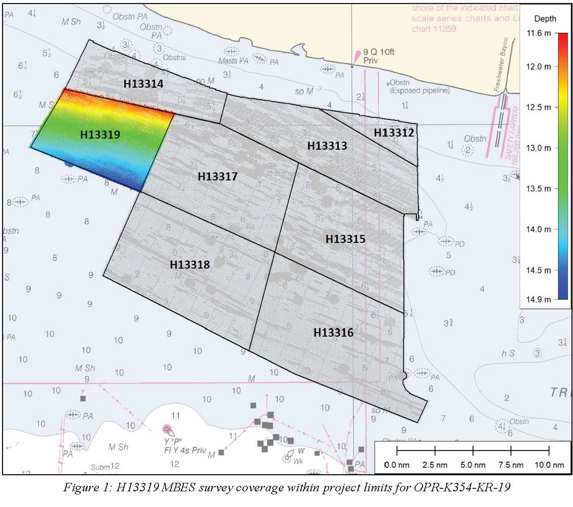
Federal
H13319: NOS Hydrographic Survey , 2020-02-23
National Oceanic and Atmospheric Administration, Department of Commerce —
The National Oceanic and Atmospheric Administration (NOAA) has the statutory mandate to collect hydrographic data in support of nautical chart compilation for safe... -
Federal
H13318: NOS Hydrographic Survey , 2020-03-11
National Oceanic and Atmospheric Administration, Department of Commerce —
The National Oceanic and Atmospheric Administration (NOAA) has the statutory mandate to collect hydrographic data in support of nautical chart compilation for safe... -
Federal
H13304: NOS Hydrographic Survey , 2020-10-22
National Oceanic and Atmospheric Administration, Department of Commerce —
The National Oceanic and Atmospheric Administration (NOAA) has the statutory mandate to collect hydrographic data in support of nautical chart compilation for safe... -
Federal
H13285: NOS Hydrographic Survey , 2019-11-26
National Oceanic and Atmospheric Administration, Department of Commerce —
The National Oceanic and Atmospheric Administration (NOAA) has the statutory mandate to collect hydrographic data in support of nautical chart compilation for safe... -
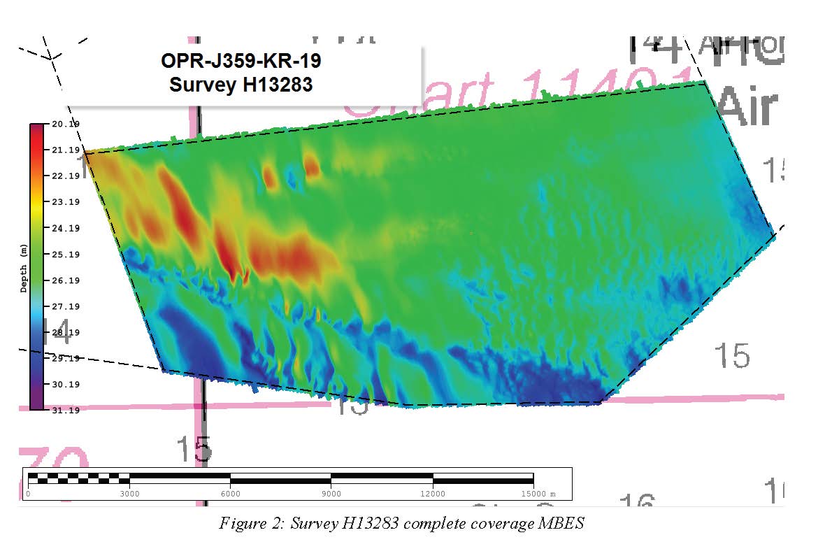
Federal
H13283: NOS Hydrographic Survey , 2019-11-26
National Oceanic and Atmospheric Administration, Department of Commerce —
The National Oceanic and Atmospheric Administration (NOAA) has the statutory mandate to collect hydrographic data in support of nautical chart compilation for safe... -
Federal
H13220: NOS Hydrographic Survey , 2019-09-29
National Oceanic and Atmospheric Administration, Department of Commerce —
The National Oceanic and Atmospheric Administration (NOAA) has the statutory mandate to collect hydrographic data in support of nautical chart compilation for safe... -
Federal
H13178: NOS Hydrographic Survey , 2019-07-24
National Oceanic and Atmospheric Administration, Department of Commerce —
The National Oceanic and Atmospheric Administration (NOAA) has the statutory mandate to collect hydrographic data in support of nautical chart compilation for safe...

Official websites use .gov
A
.gov website belongs to an official government
organization in the United States.
Secure .gov websites use HTTPS
A
lock (
) or https:// means you’ve safely connected to
the .gov website. Share sensitive information only on official,
secure websites.