
-
Federal
NCEI Standard Product: World Ocean Database (WOD)
National Oceanic and Atmospheric Administration, Department of Commerce —
The World Ocean Database (WOD) is the world's largest publicly available uniform format quality controlled ocean profile dataset. Ocean profile data are sets of... -
Federal
National Coral Reef Monitoring Program: Water chemistry of the coral reefs in the Pacific Ocean
National Oceanic and Atmospheric Administration, Department of Commerce —
This collection contains water sample data that are collected and analyzed to assess spatial and temporal variation in the seawater carbonate systems of coral reef... -
Federal
Sea level measured by tide gauges from global oceans as part of the Joint Archive for Sea Level (JASL) since 1846
National Oceanic and Atmospheric Administration, Department of Commerce —
This collection contains the complete holdings of the Joint Archive for Sea Level (JASL) for hourly and daily data that have been quality controlled, assessed, and... -
Federal
National Coral Reef Monitoring Program: Stratified Random Surveys (StRS) of Reef Fish, including Benthic Estimate Data of the Hawaiian Archipelago since 2013
National Oceanic and Atmospheric Administration, Department of Commerce —
The stationary point count (SPC) method is used to conduct reef fish surveys in the Hawaiian and Mariana Archipelagos, American Samoa, and the Pacific Remote Island... -
Federal
FNMOC Wind and Ekman Transport Data, 360x180, Monthly, from 6-hr Pressure
National Oceanic and Atmospheric Administration, Department of Commerce —
Global monthly derived winds and Ekman transports can be obtained for any point on the ocean (Northern Hemisphere: 1967 - present, Southern Hemisphere: 1981 -... -
Federal
Surface ocean radial velocities obtained by HF-radar from stations located along coastal waters of Hawaii, North Slope Alaska, Gulf of Alaska, Puerto Rico/Virgin Islands, eastern U.S./Gulf of America, western U.S., and the Great Lakes
National Oceanic and Atmospheric Administration, Department of Commerce —
This dataset contains surface ocean radial velocities data obtained by HF-radar from stations located along coastal waters of the United States. Radial velocity files... -
Federal
Fisheries One Stop Shop Public Data 2009 - Present
National Oceanic and Atmospheric Administration, Department of Commerce —
The purpose of the Fisheries One-Stop-Shop (FOSS) is to make fisheries dependent information readily available to fisheries managers, scientists and the American... -
Federal
NOAA/WDS Paleoclimatology - Minicoy Island, Lakshadweep, Arabian Sea, 1980-2013 CE, Porites lutea Coral d11B, Sr/Ca, Li/Ca, Mg/Ca, pK*B and pH Data
National Oceanic and Atmospheric Administration, Department of Commerce —
This archived Paleoclimatology Study is available from the NOAA National Centers for Environmental Information (NCEI), under the World Data Service (WDS) for... -
Federal
NOAA/WDS Paleoclimatology - Sea surface temperature and Atlantic Meridional Overturning Circulation of the last 21,000 years
National Oceanic and Atmospheric Administration, Department of Commerce —
This archived Paleoclimatology Study is available from the NOAA National Centers for Environmental Information (NCEI), under the World Data Service (WDS) for... -
Federal
A01 Directional Waves
National Oceanic and Atmospheric Administration, Department of Commerce —
Ocean observation data from the Northeastern Regional Association of Coastal & Ocean Observing Systems (NERACOOS). The NERACOOS region includes the northeast... -
Federal
D00255: NOS Hydrographic Survey , 2018-09-20
National Oceanic and Atmospheric Administration, Department of Commerce —
The National Oceanic and Atmospheric Administration (NOAA) has the statutory mandate to collect hydrographic data in support of nautical chart compilation for safe... -
Federal
Chemical, physical, profile and other oceanographic data collected aboard the GYRE in the Gulf of Mexico from 2010-09-25 to 2010-09-28 in response to the Deepwater Horizon Oil Spill event (NCEI Accession 0074905)
National Oceanic and Atmospheric Administration, Department of Commerce —
Chemical, physical, profile, imagery, laboratory analysis and sediment analysis oceanographic data were collected aboard the GYRE in the Gulf of Mexico from... -
Federal
National Coral Reef Monitoring Program: Stratified Random Surveys (StRS) of Coral Demography (Adult and Juvenile Corals) across the Pacific Remote Island Areas from 2014 to 2018
National Oceanic and Atmospheric Administration, Department of Commerce —
NCRMP CORAL DEMOGRAPHIC DATA HAS NOW BEEN MERGED INTO A PACIFIC-WIDE METADATA RECORD -- PLEASE REFER TO https://www.fisheries.noaa.gov/inport/item/71550 FOR MOST... -
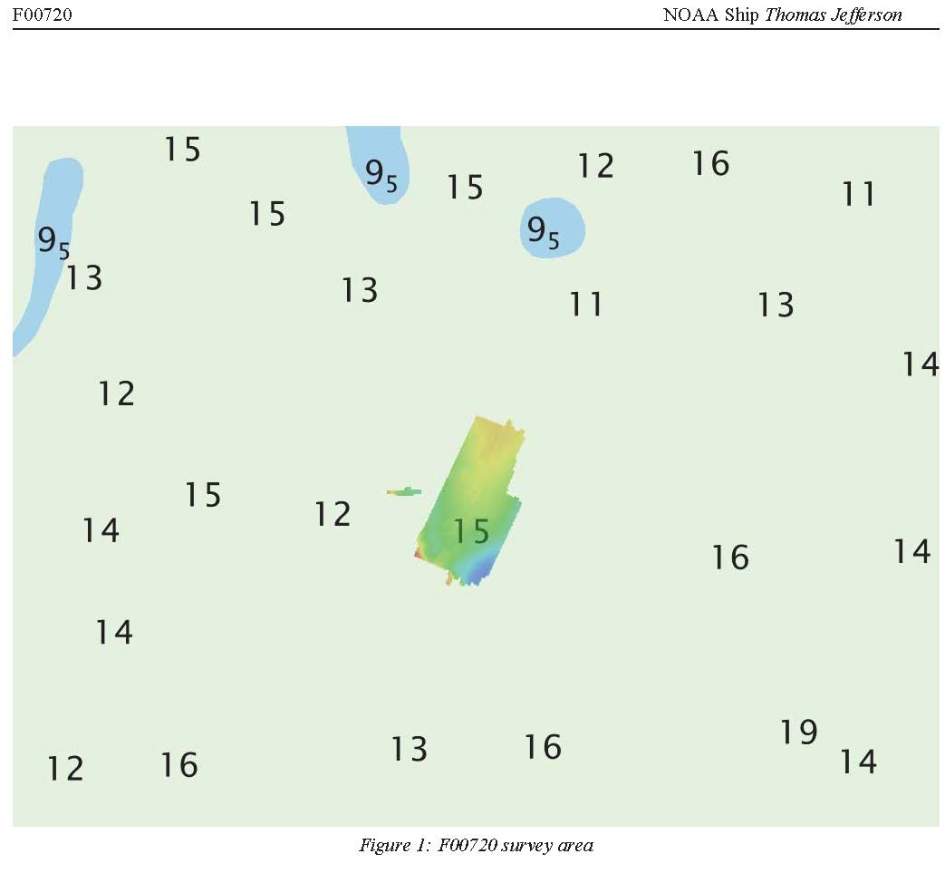
Federal
F00720: NOS Hydrographic Survey , 2018-05-01
National Oceanic and Atmospheric Administration, Department of Commerce —
The National Oceanic and Atmospheric Administration (NOAA) has the statutory mandate to collect hydrographic data in support of nautical chart compilation for safe... -
Federal
Near-real-time surface ocean velocities derived from HF-radar stations located along coastal waters of North Slope Alaska, Gulf of Alaska, Puerto Rico/Virgin Islands, eastern U.S./Gulf of America, Hawaii, Great Lakes, and western U.S.
National Oceanic and Atmospheric Administration, Department of Commerce —
This dataset contains near-real-time ocean surface velocities, also known as total vector velocities, derived from high-frequency (HF) radar stations. The velocities... -
Federal
N01 Accelerometer - Waves
National Oceanic and Atmospheric Administration, Department of Commerce —
Ocean observation data from the Northeastern Regional Association of Coastal & Ocean Observing Systems (NERACOOS). The NERACOOS region includes the northeast... -
Federal
osu035-20090805T0256-delayed
National Oceanic and Atmospheric Administration, Department of Commerce —
Underwater glider observations from along and near the Newport, Oregon, Hydrographic Line (44-deg 39.1' N) collected as part of a series of long-term studies of... -
Federal
osu592-20160823T2031-delayed
National Oceanic and Atmospheric Administration, Department of Commerce —
Underwater glider observations from along and near the Newport, Oregon, Hydrographic Line (44-deg 39.1' N) collected as part of a series of long-term studies of... -
Federal
osu033-20071030T1842-delayed
National Oceanic and Atmospheric Administration, Department of Commerce —
Underwater glider observations from along and near the Newport, Oregon, Hydrographic Line (44-deg 39.1' N) collected as part of a series of long-term studies of... -
Federal
Chemical, physical, profile and laboratory analysis oceanographic data collected aboard the OCEAN VERITAS in the Gulf of Mexico from 2010-06-01 to 2010-06-05 in response to the Deepwater Horizon Oil Spill event (NCEI Accession 0069093)
National Oceanic and Atmospheric Administration, Department of Commerce —
Chemical, physical, profile and laboratory analysis oceanographic data were collected aboard the OCEAN VERITAS in the Gulf of Mexico from 2010-06-01 to 2010-06-05 in...

Official websites use .gov
A
.gov website belongs to an official government
organization in the United States.
Secure .gov websites use HTTPS
A
lock (
) or https:// means you’ve safely connected to
the .gov website. Share sensitive information only on official,
secure websites.