

6 datasets found for "disaster"
-
Federal
Geocoded Disasters (GDIS) Dataset
National Aeronautics and Space Administration —
The Geocoded Disasters (GDIS) Dataset is a geocoded extension of a selection of natural disasters from the Centre for Research on the Epidemiology of Disasters'... -
Federal
Aerial Photographs (from AMES Pilot Land Data System); USGS EDC, Sioux Falls
National Aeronautics and Space Administration —
The aerial photography inventoried by the Pilot Land Data System (PLDS) at NASA AMES Research Center has been transferred to the USGS EROS Data Center. The photos... -
Federal
INFORM Global Risk Index 2019 Mid Year, v0.3.7
National Aeronautics and Space Administration —
The INFORM Global Risk Index 2019 Mid Year, v0.3.7 data set identifies the countries at a high risk of humanitarian crisis that are more likely to require... -
Federal
West Africa Coastal Vulnerability Mapping: Demographic and Health Survey Data Sets
National Aeronautics and Space Administration —
The West Africa Coastal Vulnerability Mapping: Demographic and Health Survey Data Sets present grids of maternal education levels and household wealth based on... -
Federal
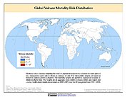
Global Volcano Mortality Risks and Distribution
National Aeronautics and Space Administration —
Global Volcano Mortality Risks and Distribution is a 2.5 minute grid representing global volcano mortality risks. The data set was constructed using historical... -
Federal
HDDS_Baseline_Adhoc
National Aeronautics and Space Administration —
The U.S. Geological Survey (USGS) Emergency Operations, in support of the Department of Homeland Security, provides imagery and resources for use in disaster...
6 datasets found for "disaster"