
-
Federal
Global Landslide Hazard Distribution
National Aeronautics and Space Administration —
The Global Landslide Hazard Distribution is a 2.5 minute grid of global landslide and snow avalanche hazards based upon work of the Norwegian Geotechnical Institute... -
Federal
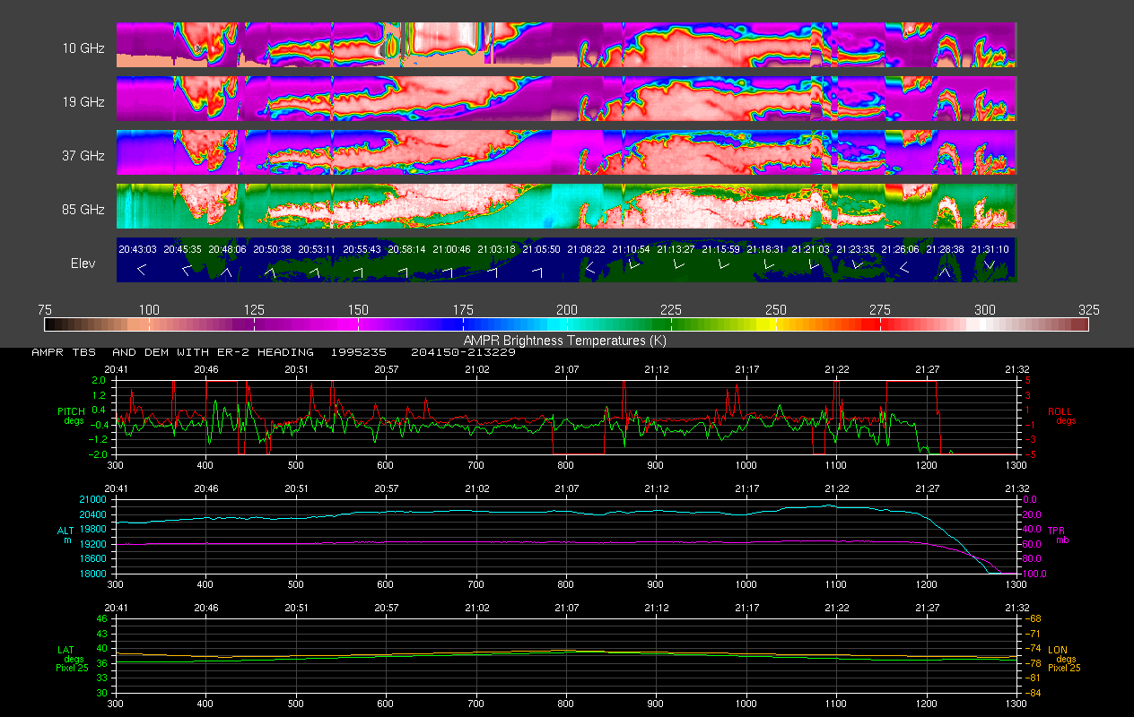
AMPR BRIGHTNESS TEMPERATURE CAMEX-1 V2
National Aeronautics and Space Administration —
The Advanced Microwave Precipitation Radiometer (AMPR) was deployed during the Convection and Moisture Experiments (CAMEX-1) conducted at Wallops Island, VA. AMPR... -
Federal
Global Gridded Geographically Based Economic Data (G-Econ), Version 4
National Aeronautics and Space Administration —
The Global Gridded Geographically Based Economic Data (G-Econ), Version 4 contains derived one degree grid cells of Gross Domestic Product (GDP) data in Grid and... -
Federal
GPM GROUND VALIDATION NASA MICRO RAIN RADAR (MRR) MC3E V1
National Aeronautics and Space Administration —
The GPM Ground Validation NASA Micro Rain Radar (MRR) MC3E dataset was collected by a Micro Rain Radar (MRR), which is a vertically pointing Doppler radar which... -
Federal
TRMM Microwave Imager Precipitation Profile L3 1 month 0.5 degree x 0.5 degree V7 (TRMM_3A12) at GES DISC
National Aeronautics and Space Administration —
The new equivalent for this dataset should be searched for as "GPM_3GPROFTRMMTMI_CLIM". This product contains global monthly means of surface precipitation rate, rain... -
Federal
TRMM Precipitation Radar Rainfall Rate and Profile L2 1.5 hours V7 (TRMM_2A25) at GES DISC
National Aeronautics and Space Administration —
The new version of these data is in GPM-like format (consistent with the GPM Dual-frequency Radar data format), and can be found under the name GPM_2APR. The TRMM... -
Federal
TRMM Precipitation Radar Rain Characteristics L2 1.5 hours V7 (TRMM_2A23) at GES DISC
National Aeronautics and Space Administration —
The new version of these data is in GPM-like format (consistent with the GPM Dual-frequency Radar data format), and can be found under the name GPM_2APR. The TRMM... -
Federal
Legates Surface and Ship Observations of Precipitation Climatology 0.5 x 0.5 degree V1 (RAIN_LEGATES) at GES DISC
National Aeronautics and Space Administration —
The Legates Surface and Shipboard Rain Gauge Observations data set consists of a global climatology of monthly mean precipitation values. A global climatology of mean... -
Federal
SMAPVEX16 Manitoba Station Soil Moisture Data V001
National Aeronautics and Space Administration —
This data set contains soil moisture, temperature, and precipitation data collected at temporary soil stations and the Real-time In-Situ Soil Monitoring for... -
Federal
TROPICS07 L2A Unified Resolution Brightness Temperatures V0.2
National Aeronautics and Space Administration —
The "Time-Resolved Observations of Precipitation structure and storm Intensity with a Constellation of Smallsats" (TROPICS) mission has a goal of providing nearly... -
Federal
TROPICS01 Pathfinder L2A Unified Resolution Brightness Temperatures V1.0
National Aeronautics and Space Administration —
The "Time-Resolved Observations of Precipitation structure and storm Intensity with a Constellation of Smallsats" (TROPICS) mission has a goal of providing nearly... -
Federal
High Mountain Asia Daily 0.05 x 0.05 deg Noah-MP Land Surface Model Reanalysis V001
National Aeronautics and Space Administration —
This data set consists of a water budget reanalysis for the High Mountain Asia (HMA) region spanning the years 2003 through 2020. Estimates are provided for more than... -
Federal
SBU Pluvio Precipitation Gauge IMPACTS V1
National Aeronautics and Space Administration —
The SBU Pluvio Precipitation Gauge IMPACTS dataset consists of precipitation intensity and precipitation accumulation collected using the OTT Pluvio2 weighing rain... -
Federal
Monthly Historical Water Balance Products for the CONUS
National Aeronautics and Space Administration —
This dataset provides daily historical Water Balance Model outputs from a Thornthwaite-type, single bucket model. Climate inputs to the model are from GridMet daily... -
Federal
AIRS/Aqua L2 Near Real Time (NRT) Support Retrieval (AIRS-only) V006 (AIRS2SUP_NRT) at GES DISC
National Aeronautics and Space Administration —
The Atmospheric Infrared Sounder (AIRS) Level 2 Near Real Time (NRT) Support Retrieval (AIRS-only) product (AIRS2SUP_NRT_006) differs from the routine product... -
Federal
Cloud Radar System (CRS) IMPACTS V1
National Aeronautics and Space Administration —
The Cloud Radar System (CRS) IMPACTS dataset consists of calibrated radar reflectivity, Doppler velocity, linear depolarization ratio, and normalized radar cross-... -
Federal
AMSR-E L2 Rainfall Subset, collocated with CloudSat track V002 (AMSERR_CPR) at GES DISC
National Aeronautics and Space Administration —
This is a subset of AMSR-E rain rate product along CloudSat field of view track. The goal of the subset is to select and return AMSR-E data that are within -100 km... -
Federal
GPM DPR Ku-band Received Power L1B 1.5 hours 5 km V07 (GPM_PRL1KU) at GES DISC
National Aeronautics and Space Administration —
Version 07 is the current version of the data set. Older versions are no longer available and have been superseded by Version 07. This product contains the calibrated... -
Federal
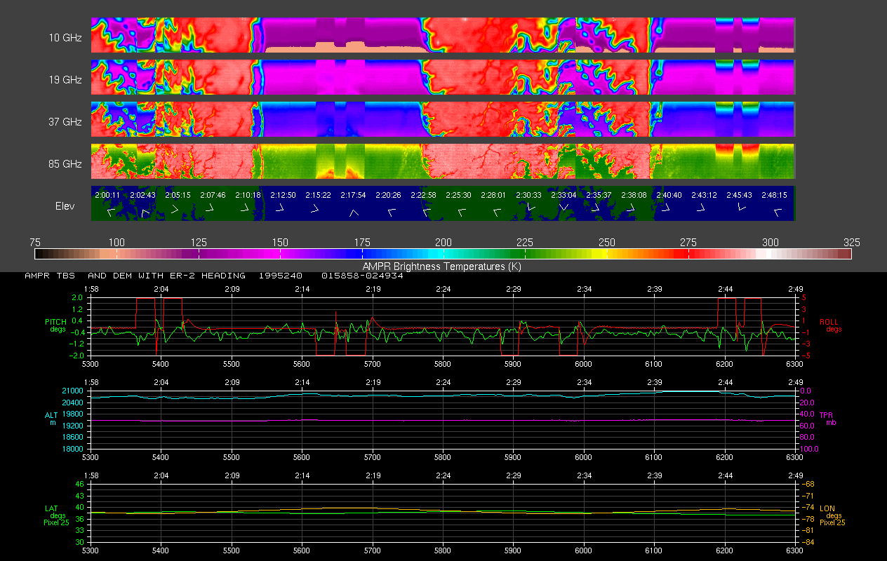
AMPR BRIGHTNESS TEMPERATURE CAMEX-2 V2
National Aeronautics and Space Administration —
The Advanced Microwave Precipitation Radiometer (AMPR) was deployed during the Convection and Moisture Experiment 2 (CAMEX-2). AMPR data were collected at a...

Official websites use .gov
A
.gov website belongs to an official government
organization in the United States.
Secure .gov websites use HTTPS
A
lock (
) or https:// means you’ve safely connected to
the .gov website. Share sensitive information only on official,
secure websites.