
-
Federal
Potential Impacts of Climate Change on World Food Supply: Datasets from a Major Crop Modeling Study
National Aeronautics and Space Administration —
The Potential Impacts of Climate Change on World Food Supply: Datasets from a Major Crop Modeling Study contain projected country and regional changes in grain crop... -
Federal
Global Pesticide Grids (PEST-CHEMGRIDS), Version 1.01
National Aeronautics and Space Administration —
The Global Pesticide Grids (PEST-CHEMGRIDS), Version 1.01 data set contains 20 of the most-used pesticide active ingredients on 6 dominant crops and 4 aggregated crop... -
Federal
Last of the Wild Project, Version 3 (LWP-3): 2009 Human Footprint, 2018 Release
National Aeronautics and Space Administration —
The 2009 Human Footprint, 2018 Release provides a global map of the cumulative human pressure on the environment in 2009, at a spatial resolution of ~1 km. The human... -
Federal
SMAPVEX16 Manitoba CropScan Data V001
National Aeronautics and Space Administration —
This data set contains CropScan observations (solar irradiance and incidence angle) collected for the Soil Moisture Active Passive Validation Experiment 2016 Manitoba... -
Federal
Global Fertilizer and Manure, Version 1: Nitrogen Fertilizer Application
National Aeronautics and Space Administration —
The Nitrogen Fertilizer Application data set of the Global Fertilizer and Manure, Version 1 Data Collection represents the amount of nitrogen fertilizer nutrients... -
Federal
West Africa Coastal Vulnerability Mapping: Commercial Crop Production, 2000
National Aeronautics and Space Administration —
The West Africa Coastal Vulnerability Mapping: Commercial Crop Production, 2000 data set includes 5-minute rasters of crop production in metric tons per grid cell for... -
Federal
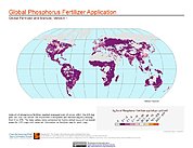
Global Fertilizer and Manure, Version 1: Phosphorus Fertilizer Application
National Aeronautics and Space Administration —
The Phosphorus Fertilizer Application data set of the Global Fertilizer and Manure, Version 1 Data Collection represents the amount of phosphorus fertilizer nutrients... -
Federal
Effects of Climate Change on Global Food Production from SRES Emissions and Socioeconomic Scenarios
National Aeronautics and Space Administration —
The Effects of Climate Change on Global Food Production from SRES Emissions and Socioeconomic Scenarios is an update to a major crop modeling study by the NASA... -
Federal
Aerial Photographs (from AMES Pilot Land Data System); USGS EDC, Sioux Falls
National Aeronautics and Space Administration —
The aerial photography inventoried by the Pilot Land Data System (PLDS) at NASA AMES Research Center has been transferred to the USGS EROS Data Center. The photos... -
Federal
West Africa Coastal Vulnerability Mapping: GPW Version 4 Population Density, Preliminary Release 1, 2010
National Aeronautics and Space Administration —
The West Africa Coastal Vulnerability Mapping: GPW Version 4 Population Density, Preliminary Release 1, 2010, represents the number of persons per square kilometer,... -
Federal
SMAPVEX16 Manitoba In Situ Vegetation Data V001
National Aeronautics and Space Administration —
This data set contains in situ measurements of crop density, height, and biomass collected for the Soil Moisture Active Passive Validation Experiment 2016 Manitoba... -
Federal
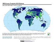
Last of the Wild Project, Version 3 (LWP-3): 1993 Human Footprint, 2018 Release
National Aeronautics and Space Administration —
The 1993 Human Footprint, 2018 Release provides a global map of the cumulative human pressure on the environment in 1993, at a spatial resolution of ~1 km. The human... -
Federal
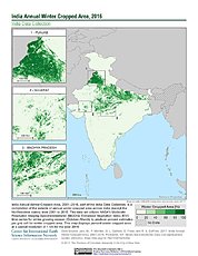
India Annual Winter Cropped Area, 2001-2016 NGDA
National Aeronautics and Space Administration —
The India Annual Winter Cropped Area, 2001 - 2016 consists of annual winter cropped areas for most of India (except the Northeastern states) from 2000-2001 to... -
Federal
Twentieth Century Crop Statistics, 1900-2017
National Aeronautics and Space Administration —
The Twentieth Century Crop Statistics, 1900-2017 data set consists of national or subnational maize and wheat production, yield, and harvested area statistics for all... -
Federal
Groundswell Spatial Population and Migration Projections at One-Eighth Degree According to SSPs and RCPs, 2010-2050
National Aeronautics and Space Administration —
The Groundswell Spatial Population and Migration Projections at One-Eighth Degree According to SSPs and RCPs, 2010-2050, data set provides a baseline population... -
Federal
West Africa Coastal Vulnerability Mapping: GPW Version 4 Population Growth, Preliminary Release 1, 2000-2010
National Aeronautics and Space Administration —
The West Africa Coastal Vulnerability Mapping: GPW Version 4 Population Growth, Preliminary Release 1, 2000-2010, represents positive or negative growth in the number... -
Federal
Groundswell Africa Spatial Population and Migration Projections at One-Eighth Degree According to SSPs and RCPs, 2010-2050
National Aeronautics and Space Administration —
The Groundswell Africa Spatial Population and Migration Projections at One-Eighth Degree According to SSPs and RCPs, 2010-2050 data set provides a baseline population... -
Federal
SMAPVEX16 Manitoba CropScan Data V001
National Aeronautics and Space Administration —
This data set contains CropScan observations (solar irradiance and incidence angle) collected for the Soil Moisture Active Passive Validation Experiment 2016 Manitoba...

Official websites use .gov
A
.gov website belongs to an official government
organization in the United States.
Secure .gov websites use HTTPS
A
lock (
) or https:// means you’ve safely connected to
the .gov website. Share sensitive information only on official,
secure websites.