
-
Federal
India Village-Level Geospatial Socio-Economic Data Set: 1991, 2001
National Aeronautics and Space Administration —
The India Village-Level Geospatial Socio-Economic Data Set: 1991, 2001 is a compilation of the finest level of administrative boundaries in India (village/town-level)... -
Federal
Global Roads Open Access Data Set, Version 1 (gROADSv1)
National Aeronautics and Space Administration —
The Global Roads Open Access Data Set, Version 1 (gROADSv1) was developed under the auspices of the CODATA Global Roads Data Development Task Group. The data set... -
Federal
Spatial Data from the 2011 India Census
National Aeronautics and Space Administration —
The Spatial Data from the 2011 India Census contains gridded estimates of India population at a resolution of 1 kilometer along with two spatial renderings of urban... -
Federal
Historical Urban Population: 3700 BC - AD 2000
National Aeronautics and Space Administration —
The Historical Urban Population, 3700 BC - AD 2000, originally developed by the Yale School of Forestry & Environmental Studies, is the first spatially explicit... -
Federal
OrbView-2 SeaWiFS Global Mapped Remote-Sensing Reflectance (RRS) Data, version R2022.0
National Aeronautics and Space Administration —
The SeaWiFS instrument was launched by Orbital Sciences Corporation on the OrbView-2 (a.k.a. SeaStar) satellite in August 1997, and collected data from September 1997... -
Federal
Last of the Wild Project, Version 2, 2005 (LWP-2): Global Human Influence Index (HII) Dataset (Geographic)
National Aeronautics and Space Administration —
The Global Human Influence Index Dataset of the Last of the Wild Project, Version 2, 2005 (LWP-2) is a global dataset of 1-kilometer grid cells, created from nine... -
Federal
Poverty Mapping Project: Global Subnational Prevalence of Child Malnutrition
National Aeronautics and Space Administration —
The Poverty Mapping Project: Global Subnational Prevalence of Child Malnutrition data set consists of estimates of the percentage of children with weight-for-age... -
Federal
CORONA Satellite Photographs from the U.S. Geological Survey
National Aeronautics and Space Administration —
The first generation of U.S. photo intelligence satellites collected more than 860,000 images of the Earth’s surface between 1960 and 1972. The classified military... -
Federal
Global Cyclone Proportional Economic Loss Risk Deciles
National Aeronautics and Space Administration —
The Global Cyclone Proportional Economic Loss Risk Deciles is a 2.5 minute grid of cyclone hazard economic loss as proportions of Gross Domestic Product (GDP) per... -
Federal
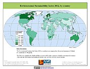
2002 Environmental Sustainability Index (ESI)
National Aeronautics and Space Administration —
The 2002 Environmental Sustainability Index (ESI) measures overall progress toward environmental sustainability for 142 countries based on environmental systems,... -
Federal
JPL TELLUS GRACE Level-3 Monthly Land Water-Equivalent-Thickness Surface Mass Anomaly Release 6.0 version 04 in netCDF/ASCII/GeoTIFF Formats
National Aeronautics and Space Administration —
The monthly land mass grids contain water mass anomalies given as equivalent water thickness derived from GRACE & GRACE-FO time-variable gravity observations... -
Federal
U.S. Climate Risk Projections by County, 2040-2049
National Aeronautics and Space Administration —
The U.S. Climate Risk Projections by County, 2040-2049 data set contains a projection for 2040-2049 risk for the entire contiguous U.S. at the county level with a... -
Federal
Terra MODIS Global Binned Fluorescence Line Height (FLH) - Near Real Time (NRT) Data, version R2022.0 NGDA
National Aeronautics and Space Administration —
The Ocean Biology DAAC produces near real-time (quicklook) products using the best-available combination of ancillary data from meteorological and ozone data. As... -
Federal
Last of the Wild Project, Version 2, 2005 (LWP-2): Global Human Footprint Dataset (Geographic)
National Aeronautics and Space Administration —
The Global Human Footprint Dataset of the Last of the Wild Project, Version 2, 2005 (LWP-2) is the Human Influence Index (HII) normalized by biome and realm. The HII... -
Federal
SMAP L4 Global 9 km EASE-Grid Surface and Root Zone Soil Moisture Land Model Constants V007
National Aeronautics and Space Administration —
SMAP Level-4 (L4) surface and root zone soil moisture data are provided in three products: * SMAP L4 Global 3-hourly 9 km EASE-Grid Surface and Root Zone Soil... -
Federal
MODIS/Aqua Sea Ice Extent and IST Daily L3 Global 4km EASE-Grid Day V061 NGDA
National Aeronautics and Space Administration —
This global Level-3 (L3) data set provides Northern and Southern Hemisphere maps of sea ice extent and ice surface temperature. The maps are generated by compositing... -
Federal
SASSIE Arctic Field Campaign Drifter Hydrography Data Fall 2022 Version 2p
National Aeronautics and Space Administration —
The Salinity and Stratification at the Sea Ice Edge (SASSIE) project is a NASA experiment that aims to understand how salinity anomalies in the upper ocean generated...

Official websites use .gov
A
.gov website belongs to an official government
organization in the United States.
Secure .gov websites use HTTPS
A
lock (
) or https:// means you’ve safely connected to
the .gov website. Share sensitive information only on official,
secure websites.