
-
Federal
ASTER Global DEM NGDA
National Aeronautics and Space Administration —
ASTER is capable of collecting in-track stereo using nadir- and aft-looking near infrared cameras. Since 2001, these stereo pairs have been used to produce single-... -
Federal
Spatial Data from the 2011 India Census
National Aeronautics and Space Administration —
The Spatial Data from the 2011 India Census contains gridded estimates of India population at a resolution of 1 kilometer along with two spatial renderings of urban... -
Federal
India Village-Level Geospatial Socio-Economic Data Set: 1991, 2001
National Aeronautics and Space Administration —
The India Village-Level Geospatial Socio-Economic Data Set: 1991, 2001 is a compilation of the finest level of administrative boundaries in India (village/town-level)... -
Federal
2022 Environmental Performance Index (EPI)
National Aeronautics and Space Administration —
The 2022 Environmental Performance Index (EPI) ranks 180 countries on 40 performance indicators in the following 11 issue categories: air quality, sanitation and... -
Federal
SDG Indicator 7.1.1: Access to Electricity, 2023 Release
National Aeronautics and Space Administration —
The SDG Indicator 7.1.1: Access to Electricity, 2023 Release data set, part of the Sustainable Development Goal Indicators (SDGI) collection, measures the proportion... -
Federal
Global Fertilizer and Manure, Version 1: Nitrogen in Manure Production
National Aeronautics and Space Administration —
The Nitrogen in Manure Production data set of the Global Fertilizer and Manure, Version 1 Data Collection represents the amount of nitrogen manure produced and... -
Federal
Global Annual PM2.5 Grids from MODIS, MISR and SeaWiFS Aerosol Optical Depth (AOD), 1998-2019, V4.GL.03 NGDA
National Aeronautics and Space Administration —
The Global Annual PM2.5 Grids from MODIS, MISR and SeaWiFS Aerosol Optical Depth (AOD), 1998-2019, V4.GL.03 consists of annual concentrations (micrograms per cubic... -
Federal
Population Exposure Estimates in Proximity to Nuclear Power Plants, Locations
National Aeronautics and Space Administration —
The Population Exposure Estimates in Proximity to Nuclear Power Plants, Locations data set combines information from a global data set developed by Declan Butler of... -
Federal
TOVS GLA DAILY GRIDS from NOAA-10 V01 (TOVSADNG) at GES DISC
National Aeronautics and Space Administration —
This dataset (TOVSADNG) contains the TIROS Operational Vertical Sounder (TOVS) level 3 geophysical parameters derived using data from NOAA-10 and the physical... -
Federal
Global Land Survey
National Aeronautics and Space Administration —
The U.S. Geological Survey (USGS) and the National Aeronautics and Space Administration (NASA) collaborated on the creation of the global land datasets using Landsat... -
Federal
SnowEx21 Time Series Snow Pits V001
National Aeronautics and Space Administration —
The data set is a time-series of snow pit measurements obtained by the SnowEx community during the 2021 field campaign. etween November 2020 and May 2021 data from... -
Federal
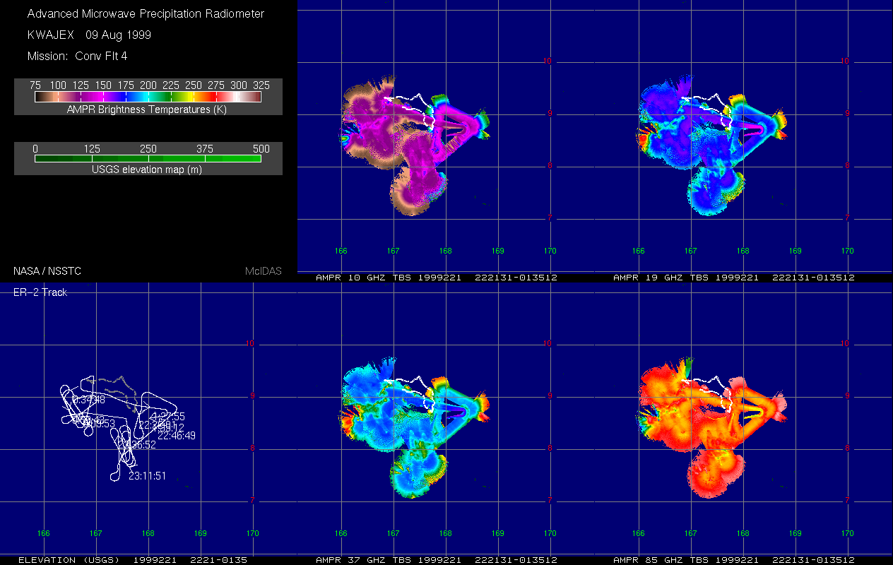
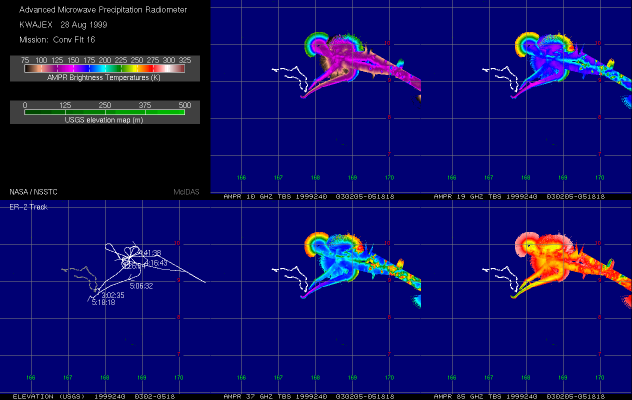
AMPR BRIGHTNESS TEMPERATURE (TB) KWAJEX V1
National Aeronautics and Space Administration —
The Advanced Microwave Precipitation Radiometer (AMPR) was deployed during the First Kwajelein Experiment (KWAJEX), which provided Ground Validation for instruments... -
Federal
ASO L4 Lidar Snow Depth 3m UTM Grid V001
National Aeronautics and Space Administration —
This data set contains 3 m gridded snow depths derived from airborne light detection and ranging, or lidar, measurements of surface elevations. The data were... -
Federal
GOES-R PLT Field Campaign Airborne Visible/Infrared Imaging Spectrometer Next Generation (AVIRIS-NG) V1
National Aeronautics and Space Administration —
The GOES-R PLT Field Campaign Airborne Visible/Infrared Imaging Spectrometer Next Generation (AVIRIS-NG) dataset consists of radiance, reflectance, water phase, and... -
Federal
High-Resolution QuickBird Imagery and Related GIS Layers for Barrow, Alaska, USA, Version 1
National Aeronautics and Space Administration —
This data set contains high-resolution QuickBird imagery and geospatial data for the entire Barrow QuickBird image area (156.15° W - 157.07° W, 71.15° N - 71.41° N)... -
Federal
OLCI/Sentinel-3A L1 Full Resolution Top of Atmosphere Reflectance
National Aeronautics and Space Administration —
The OLCI/Sentinel-3A L1 Full Resolution Top of Atmosphere Reflectance product, S3A_OL_1_EFR is generated from the data aquired by the Ocean and Land Colour Instrument... -
Federal
Africa Climate Mobility Initiative (ACMI): Internal Migration Projections
National Aeronautics and Space Administration —
The Africa Climate Mobility Initiative (ACMI) Internal Migration Projections project internal migration flows at 5-year intervals from 2020 to 2050 for a combination... -
Federal
ASO L4 Lidar Point Cloud Digital Terrain Model 3m UTM Grid V001
National Aeronautics and Space Administration —
This data set provides 3 m gridded, bare-earth elevations (excluding trees) that are used as the baseline for the Airborne Snow Observatory (ASO) snow-on products.... -
Federal
MLS/Aura Near-Real-Time L2 Sulfur Dioxide (SO2) Mixing Ratio V005 (ML2SO2_NRT) at GES DISC
National Aeronautics and Space Administration —
ML2SO2_NRT is the EOS Aura Microwave Limb Sounder (MLS) Near-Real-Time (NRT) product for sulfur dioxide (SO2). This product contains SO2 profiles derived from the 190... -
Federal
OCO-3 Level 2 CO2 prior based on CO2 monthly flask record, global meteorology, and age of air, Forward Processing V11 (OCO3_L2_CO2Prior) at GES DISC
National Aeronautics and Space Administration —
Version 11 is the current version of the data set. Older versions will no longer be available and are superseded by Version 11. The Orbiting Carbon Observatory -3...

Official websites use .gov
A
.gov website belongs to an official government
organization in the United States.
Secure .gov websites use HTTPS
A
lock (
) or https:// means you’ve safely connected to
the .gov website. Share sensitive information only on official,
secure websites.