
-
Federal
NACP North American Forest Dynamics Project: Forest Disturbance and Regrowth Data 14 recent views
National Aeronautics and Space Administration —
This data set provides the results of time-series analyses of Landsat imagery for 55 selected forested sites across the conterminous U.S.A. The output is a pair of... -
Federal
Declassified Satellite Imagery 2 (2002)
National Aeronautics and Space Administration —
Declassified satellite images provide an important worldwide record of land-surface change. With the success of the first release of classified satellite photography... -
Federal
Soil Matric Potential, Dielectric, and Physical Properties, Arctic Alaska, 2018
National Aeronautics and Space Administration —
This dataset provides lab-measured soil properties, including soil water matric potential, soil dielectric properties, soil electrical conductivity, corresponding... -
Federal
Rock glaciers, Upper Engadin, Switzerland, Version 1
National Aeronautics and Space Administration —
The investigated region is called Upper Engadin and is situated in the Eastern part of the Swiss Alps. The area is characterized by a high situated valley floor with... -
Federal
GLDAS Catchment Land Surface Model L4 daily 0.25 x 0.25 degree GRACE-DA1 V2.2 (GLDAS_CLSM025_DA1_D) at GES DISC
National Aeronautics and Space Administration —
NASA Global Land Data Assimilation System Version 2 (GLDAS-2) has three components: GLDAS-2.0, GLDAS-2.1, and GLDAS-2.2. GLDAS-2.0 is forced entirely with the... -
Federal
LiDAR Surveys over Selected Forest Research Sites, Brazilian Amazon, 2008-2018
National Aeronautics and Space Administration —
This dataset provides the complete catalog of point cloud data collected during LiDAR surveys over selected forest research sites across the Amazon rainforest in... -
Federal
National Aggregates of Geospatial Data Collection: Population, Landscape, And Climate Estimates, Version 4 (PLACE IV)
National Aeronautics and Space Administration —
The National Aggregates of Geospatial Data Collection: Population, Landscape, And Climate Estimates, Version 4 (PLACE IV) provides measures of population (head... -
Federal
GLDAS Catchment Land Surface Model L4 daily 0.25 x 0.25 degree GRACE-DA1 V2.2 (GLDAS_CLSM025_DA1_D_EP) at GES DISC
National Aeronautics and Space Administration —
NASA Global Land Data Assimilation System Version 2 (GLDAS-2) has three components: GLDAS-2.0, GLDAS-2.1, and GLDAS-2.2. GLDAS-2.0 is forced entirely with the... -
Federal
VIIRS/NPP BRDF/Albedo Albedo Daily L3 Global 0.05Deg CMG V001
National Aeronautics and Space Administration —
The NASA/NOAA Suomi National Polar-orbiting Partnership (Suomi NPP) Visible Infrared Imaging Radiometer Suite (VIIRS) Bidirectional Reflectance Distribution Function... -
Federal
TES/Aura L2 Ancillary Special Observation Product V007
National Aeronautics and Space Administration —
TL2ANCS_7 is the Tropospheric Emission Spectrometer (TES)/Aura Level 2 Ancillary Special Observation Product Version 7 data product. TES was an instrument aboard... -
Federal
CAR Kuwait Oil Fire Spectral Reflectance L1 V1 (CAR_KUWAITOILFIRE_L1C) at GES DISC
National Aeronautics and Space Administration —
CAR Kuwait Oil Fire mission measured bidirectional reflectance function of smoke from Kuwait oil fires during the Kuwait Oil Fire Smoke Experiment. Measurements were... -
Federal
Delta-X: AirSWOT L2 Geocoded Water Surface Elevation, MRD, Louisiana, 2021, Version 2
National Aeronautics and Space Administration —
This dataset contains Level 2 (L2) AirSWOT geocoded products, including estimated water surface elevation. The AirSWOT instrument is a Ka-band interferometer and for... -
Federal
ABoVE: Reflectance Spectra of Tundra Plant Communities across Northern Alaska
National Aeronautics and Space Administration —
This dataset reports full-spectrum (350-2500 nm) reflectance measurements of diverse plant communities at the plot-level and individual plant species at the leaf-... -
Federal
Arctic Vegetation Plots at Toolik Lake, Alaska, 1989
National Aeronautics and Space Administration —
This dataset provides environmental, soil, and vegetation data collected in August 1989 from 81 study plots at the Toolik Lake research site, located in the southern... -
Federal
MODIS/Aqua Surface Reflectance Daily L2G Global 500m SIN Grid NRT NGDA
National Aeronautics and Space Administration —
The MODIS/Aqua Surface Reflectance Daily L2G Global 500m SIN Grid Near Real Time (NRT) product, short name MYD09GHK, is a seven-band product computed from the MODIS... -
Federal
VIIRS NOAA-20 (JPSS-1) 375m, I-Band Active Fire Product NRT (Vector Data)
National Aeronautics and Space Administration —
Near real-time (NRT) NOAA-20 (formally JPSS-1) Visible Infrared Imaging Radiometer Suite (VIIRS) Active Fire detection product is based on the instrument's 375 m... -
Federal
Probabilistic Freeze-Thaw Record for the Northern Hemisphere, 2016-2020
National Aeronautics and Space Administration —
This dataset provides a probabilistic freeze/thaw (FT) data record from 2016 to 2020 for the Northern Hemisphere derived using a deep learning model (U-Net). The... -
Federal
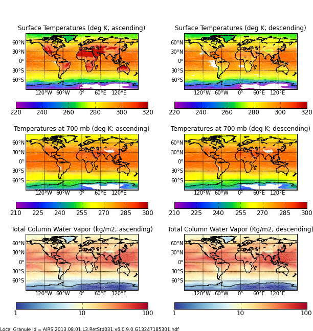
AIRS/Aqua L3 Monthly Standard Physical Retrieval (AIRS+AMSU) 1 degree x 1 degree V006 (AIRX3STM) at GES DISC
National Aeronautics and Space Administration —
The Atmospheric Infrared Sounder (AIRS) is a grating spectrometer (R = 1200) aboard the second Earth Observing System (EOS) polar-orbiting platform, EOS Aqua. In... -
Federal
CLPX-Ground: ISA Corner Site Meteorological Data, Version 1
National Aeronautics and Space Administration —
This data set contains meteorological observations at 36 sites throughout the Small Regional Study Area (SRSA) of the NASA Cold Land Processes Field Experiment (CLPX)...

Official websites use .gov
A
.gov website belongs to an official government
organization in the United States.
Secure .gov websites use HTTPS
A
lock (
) or https:// means you’ve safely connected to
the .gov website. Share sensitive information only on official,
secure websites.