
-
Federal
2020 Cartographic Boundary File (KML), Current Place for Arizona, 1:500,000 recent views
U.S. Census Bureau, Department of Commerce —
The 2020 cartographic boundary KMLs are simplified representations of selected geographic areas from the U.S. Census Bureau's Master Address File / Topologically... -
Federal
Digital Geologic-GIS Map of a portion of Petrified Forest National Park, Arizona (NPS, GRD, GRI, PEFO, PEFO digital map) adapted from a Arizona Geological Survey Contributed Map Series map by Martz, Parker, Thompson and Raucci (2012) recent views
Department of the Interior —
The Digital Geologic-GIS Map of a portion of Petrified Forest National Park, Arizona is composed of GIS data layers and GIS tables, and is available in the following... -
Federal
NOAA/WDS Paleoclimatology - Baisan fire data from Hitchcock - IMPD USHIT001 recent views
National Oceanic and Atmospheric Administration, Department of Commerce —
This archived Paleoclimatology Study is available from the NOAA National Centers for Environmental Information (NCEI), under the World Data Service (WDS) for... -
Federal
2020 Cartographic Boundary File (KML), Current State Legislative District-Lower Chamber for Arizona, 1:500,000 recent views
U.S. Census Bureau, Department of Commerce —
The 2020 cartographic boundary KMLs are simplified representations of selected geographic areas from the U.S. Census Bureau's Master Address File / Topologically... -
Federal
Digital Geologic-GIS Map of the Buell Park Quadrangle, Arizona and New Mexico (NPS, GRD, GRI, CACH, BUPA digital map) adapted from a U.S. Geological Survey Geologic Quadrangle Map by Thaden (1990) recent views
Department of the Interior —
The Digital Geologic-GIS Map of the Buell Park Quadrangle, Arizona and New Mexico is composed of GIS data layers and GIS tables, and is available in the following... -
Federal
2023 Cartographic Boundary File (KML), State Legislative District (SLD) Upper Chamber for Arizona, 1:500,000 recent views
U.S. Census Bureau, Department of Commerce —
The 2023 cartographic boundary KMLs are simplified representations of selected geographic areas from the U.S. Census Bureau's Master Address File / Topologically... -
Federal
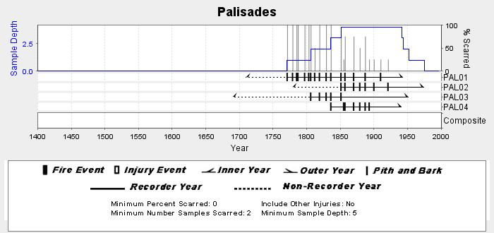
NOAA/WDS Paleoclimatology - Swetnam fire data from Palisades - IMPD USPAL001 recent views
National Oceanic and Atmospheric Administration, Department of Commerce —
This archived Paleoclimatology Study is available from the NOAA National Centers for Environmental Information (NCEI), under the World Data Service (WDS) for... -
Federal
2020 Cartographic Boundary File (KML), Current Secondary School District for Arizona, 1:500,000 recent views
U.S. Census Bureau, Department of Commerce —
The 2020 cartographic boundary KMLs are simplified representations of selected geographic areas from the U.S. Census Bureau's Master Address File / Topologically... -
Federal
2022 Cartographic Boundary File (SHP), Current State Legislative District-Upper Chamber for Arizona, 1:500,000 recent views
U.S. Census Bureau, Department of Commerce —
The 2022 cartographic boundary shapefiles are simplified representations of selected geographic areas from the U.S. Census Bureau's Master Address File /... -
Federal
2022 Cartographic Boundary File (KML), Current State Legislative District-Upper Chamber for Arizona, 1:500,000 recent views
U.S. Census Bureau, Department of Commerce —
The 2022 cartographic boundary KMLs are simplified representations of selected geographic areas from the U.S. Census Bureau's Master Address File / Topologically... -
Federal
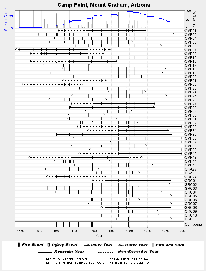
NOAA/WDS Paleoclimatology - Grissino-Mayer fire data from Camp Point, Mount Graham - IMPD USCMP001 recent views
National Oceanic and Atmospheric Administration, Department of Commerce —
This archived Paleoclimatology Study is available from the NOAA National Centers for Environmental Information (NCEI), under the World Data Service (WDS) for... -
Federal
NOAA/WDS Paleoclimatology - Gungle fire data from Josephine Saddle - IMPD USJSS001 recent views
National Oceanic and Atmospheric Administration, Department of Commerce —
This archived Paleoclimatology Study is available from the NOAA National Centers for Environmental Information (NCEI), under the World Data Service (WDS) for... -
Federal
NOAA/WDS Paleoclimatology - Heinlein fire data from San Francisco Peaks (West) - IMPD USSPW001 recent views
National Oceanic and Atmospheric Administration, Department of Commerce —
This archived Paleoclimatology Study is available from the NOAA National Centers for Environmental Information (NCEI), under the World Data Service (WDS) for... -
Federal
2020 Cartographic Boundary File (SHP), Current Block Group for Arizona, 1:500,000 recent views
U.S. Census Bureau, Department of Commerce —
The 2020 cartographic boundary shapefiles are simplified representations of selected geographic areas from the U.S. Census Bureau's Master Address File /... -
Federal
2020 Cartographic Boundary File (KML), Current Block Group for Arizona, 1:500,000 recent views
U.S. Census Bureau, Department of Commerce —
The 2020 cartographic boundary KMLs are simplified representations of selected geographic areas from the U.S. Census Bureau's Master Address File / Topologically... -
Federal
2020 Cartographic Boundary File (KML), Current Census Tract for Arizona, 1:500,000 recent views
U.S. Census Bureau, Department of Commerce —
The 2020 cartographic boundary KMLs are simplified representations of selected geographic areas from the U.S. Census Bureau's Master Address File / Topologically... -
Federal
Digital Surficial Geologic-GIS Map of Tuzigoot National Monument, Arizona (NPS, GRD, GRI, TUZI, CLAR digital map) adapted from a Arizona Geological Survey Open-File Report map by House and Pearthree (1993) recent views
Department of the Interior —
The Unpublished Digital Surficial Geologic-GIS Map of Tuzigoot National Monument, Arizona is composed of GIS data layers and GIS tables in a 10.1 file geodatabase... -
Federal
Digital Geologic-GIS Map of Navajo National Monument and Vicinity, Arizona (NPS, GRD, GRI, NAVA, NAVA digital map) adapted from a U.S. Geological Survey Miscellaneous Investigations Series Map by Haynes and Hackman (1978) recent views
Department of the Interior —
The Digital Geologic-GIS Map of Navajo National Monument and Vicinity, Arizona is composed of GIS data layers and GIS tables, and is available in the following GRI-... -
Federal
Digital Geologic-GIS Map of Casa Grande Ruins National Monument and Vicinity, Arizona (NPS, GRD, GRI, CAGR, CAGR digital map) adapted from a Arizona Geological Survey unpublished digital data map by Richard, Orr, Moore and Ferguson (2006), and Arizona Geological Survey Open-File Report maps by Klawon, Pearthree, Skotnicki and Ferguson (1998), and Huckleberry (1992) recent views
Department of the Interior —
The Digital Geologic-GIS Map of Casa Grande Ruins National Monument and Vicinity, Arizona is composed of GIS data layers and GIS tables, and is available in the...

Official websites use .gov
A
.gov website belongs to an official government
organization in the United States.
Secure .gov websites use HTTPS
A
lock (
) or https:// means you’ve safely connected to
the .gov website. Share sensitive information only on official,
secure websites.