
-
Federal
RADARSAT-1_LEVEL1
National Aeronautics and Space Administration —
RADARSAT-1 Level 1 Amplitude Images -
Federal
USGS Digital Orthophoto Quadrangles
National Aeronautics and Space Administration —
A Digital Orthophoto Quadrangle (DOQ) is a computer-generated image of an aerial photograph in which the image displacement caused by terrain relief and camera tilt... -
Federal
SENTINEL-1B_SINGLE_POL_GRD_HIGH_RES
National Aeronautics and Space Administration —
Sentinel-1B Single-pol ground projected high and full resolution images -
Federal
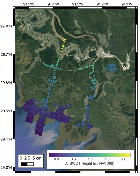
Delta-X: AirSWOT L2 Geocoded Water Surface Elevation, MRD, Louisiana, 2021, Version 2
National Aeronautics and Space Administration —
This dataset contains Level 2 (L2) AirSWOT geocoded products, including estimated water surface elevation. The AirSWOT instrument is a Ka-band interferometer and for... -
Federal
Aerial Photographs (from AMES Pilot Land Data System); USGS EDC, Sioux Falls
National Aeronautics and Space Administration —
The aerial photography inventoried by the Pilot Land Data System (PLDS) at NASA AMES Research Center has been transferred to the USGS EROS Data Center. The photos... -
Federal
LBA-ECO ND-01 Watershed Deforestation from Landsat TM Series, Rondonia, Brazil: 1999
National Aeronautics and Space Administration —
This data set provides estimates of watershed deforestation, as a proportion of the total area of watersheds, in Rondonia, Brazil for 1999. Deforestation maps were... -
Federal
Global Land Cover Characterization Program
National Aeronautics and Space Administration —
The Global Land Cover Characterization Project was established to meet science data requirements identified by the International Geosphere and Biosphere Programme... -
Federal
SENTINEL-1B_DUAL_POL_GRD_MEDIUM_RES
National Aeronautics and Space Administration —
Sentinel-1B Dual-pol ground projected medium resolution images -
Federal
Delta-X: UAVSAR L1 Single Look Complex (SLC) Stack Products, MRD, Louisiana, 2021
National Aeronautics and Space Administration —
This dataset contains UAVSAR Level 1 (L1) Single Look Complex (SLC) stack products for Delta-X flight lines acquired during 2021-03-27 to 2021-04-18 (spring) and... -
Federal
Arctic Vegetation Plots in Northern NWT and YT, Canada, 1965-1966
National Aeronautics and Space Administration —
This dataset provides vegetation, soil, and plot characteristics for 154 study plots located at three sites across the Richardson Mountains, Northwest Territories... -
Federal
ERS-2_LEVEL0
National Aeronautics and Space Administration —
ERS-2 Standard Beam Data Level 0 -
Federal
MODIS/Aqua Water Reservoir Monthly L3 Global V061 NGDA
National Aeronautics and Space Administration —
The Aqua Moderate Resolution Imaging Spectroradiometer (MODIS) Water Reservoir Monthly Level 3 (L3) Global (MYD28C3) Version 6.1 product provides current data for 151... -
Federal
Global Soil Profile Data (ISRIC-WISE)
National Aeronautics and Space Administration —
The ISRIC-WISE International soil profile data set consists of a homogenized, global set of 1,125 soil profiles for use by global modelers. These profiles provided... -
Federal
Delta-X: AirSWOT L3 Water Surface Elevations, MRD, Louisiana, 2021
National Aeronautics and Space Administration —
This dataset contains water surface elevations at selected point locations generated from the AirSWOT data collected during the Spring and Fall 2021 Delta-X... -
Federal
SENTINEL-1A_SINGLE_POL_GRD_MEDIUM_RES
National Aeronautics and Space Administration —
Sentinel-1A Single-pol ground projected medium resolution images -
Federal
SENTINEL-1B_DUAL_POL_GRD_HIGH_RES
National Aeronautics and Space Administration —
Sentinel-1B Dual-pol ground projected high and full resolution images -
Federal
SENTINEL-1B_RAW
National Aeronautics and Space Administration —
Sentinel-1B level zero product -
Federal
SENTINEL-1B_METADATA_RAW
National Aeronautics and Space Administration —
Metadata for Sentinel-1B level zero product -
Federal
SENTINEL-1B_SINGLE_POL_GRD_MEDIUM_RES
National Aeronautics and Space Administration —
Sentinel-1B Single-pol ground projected medium resolution images

Official websites use .gov
A
.gov website belongs to an official government
organization in the United States.
Secure .gov websites use HTTPS
A
lock (
) or https:// means you’ve safely connected to
the .gov website. Share sensitive information only on official,
secure websites.