

3 datasets found
-
Federal
High Mountain Asia 5 Arc-Minute Hydrological Flow Direction for the Headwaters of the Amu Darya and Indus River Basins V001
National Aeronautics and Space Administration —
TEMP: This High Mountain Asia (HMA) data set consists of a 5 arc-minute hydrological flow network for parts of Afghanistan, Tajikistan, Kyrgyzstan, and Pakistan... -
Federal
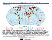
Water Security Indicator Model - Global Land Data Assimilation System (WSIM-GLDAS) Monthly Grids, Version 1
National Aeronautics and Space Administration —
The Water Security Indicator Model - Global Land Data Assimilation System (WSIM-GLDAS) Monthly Grids, Version 1 data set identifies and characterizes surpluses and... -
Federal
Trends in Global Freshwater Availability from the Gravity Recovery and Climate Experiment (GRACE)
National Aeronautics and Space Administration —
The Trends in Global Freshwater Availability from the Gravity Recovery and Climate Experiment (GRACE), 2002-2016, is a global gridded data set at a spatial resolution...
3 datasets found