
-
Federal
ISLSCP II Atmospheric Carbon Dioxide Consumption by Continental Erosion recent views
National Aeronautics and Space Administration —
The Continental Atmospheric CO2 Consumption data set represents gridded estimates for the riverine export of carbon and of sediments based on empirical models. All... -
Federal
JERS-1 Synthetic Aperture Radar, 100-m Mosaics, South America: 1995-1996, R1 recent views
National Aeronautics and Space Administration —
This data set provides ~100-m resolution image mosaics of South America acquired during the low flood season between September and December 1995 and during the high... -
Federal
BOREAS Scanning Lidar Imager of Canopies by Echo Recovery (SLICER): Level-3 Data recent views
National Aeronautics and Space Administration —
Scanning Lidar Imager of Canopies by Echo Recovery (SLICER) data were acquired in support of BOReal Ecosystem-Atmosphere Study (BOREAS) at all of the Tower Flux (TF)... -
Federal
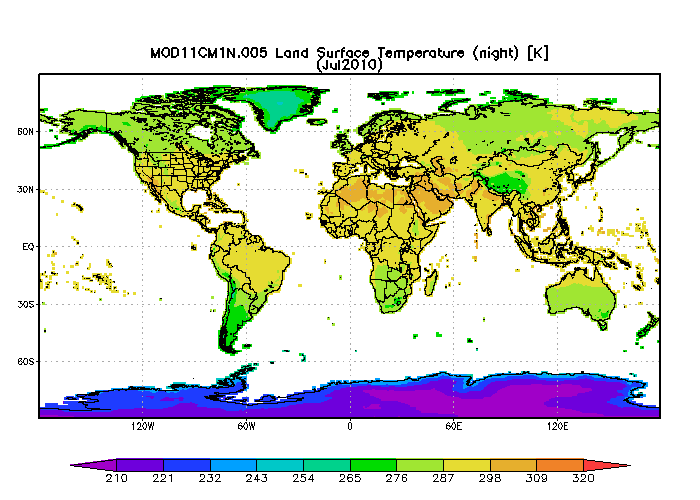
MODIS/Aqua Monthly mean Night-Time Land Surface Temperature at 1x1 degree V005 (MYD11CM1N) at GES DISC NGDA recent views
National Aeronautics and Space Administration —
The dataset contains global monthly night-time land surface temperature averaged within 1 by 1 degree grid cells. The source for the data is MODIS/Aqua MYD11C3... -
Federal
MODIS/Terra Monthly mean Night-Time Land Surface Temperature at 1x1 degree V005 (MOD11CM1N) at GES DISC NGDA recent views
National Aeronautics and Space Administration —
The dataset contains global monthly night-time land surface temperature averaged within 1 by 1 degree grid cells. The source for the data is MODIS/Terra MOD11C3... -
Federal
MODIS/Terra Monthly mean Day-Time Land Surface Temperature at 1x1 degree V005 (MOD11CM1D) at GES DISC NGDA recent views
National Aeronautics and Space Administration —
The dataset contains global monthly day-time land surface temperature averaged within 1 by 1 degree grid cells. The source for the data is MODIS/Terra MOD11C3... -
Federal
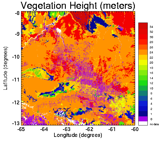
Pre-LBA CABARE Mapped Land Surface and Vegetation Characteristics, Rondonia, Brazil recent views
National Aeronautics and Space Administration —
Surface parameter digital maps of vegetation, soil, and topography were obtained for Rondonia, Brazil, covering the 5x5 degree region bounded by 13-8 degrees S and... -
Federal
MODIS/Aqua Monthly mean Day-Time Land Surface Temperature at 1x1 degree V005 (MYD11CM1D) at GES DISC NGDA recent views
National Aeronautics and Space Administration —
The dataset contains global monthly day-time land surface temperature averaged within 1 by 1 degree grid cells. The source for the data is MODIS/Aqua MYD11C3... -
Federal
Global Soil Types, 1-Degree Grid (Zobler) recent views
National Aeronautics and Space Administration —
A global digital data base of soil properties is available at 1 degree longitude resolution. For each land cell, the data base includes major and associated soil... -
Federal
ISLSCP II Global River Fluxes of Carbon and Sediments to the Oceans recent views
National Aeronautics and Space Administration —
The River Carbon Flux data set represents estimates for the riverine export of carbon and of sediments. This data set includes the amounts of carbon and of sediments... -
Federal
BOREAS Follow-On DSP-01 NBIOME Level-4 AVHRR Land Cover, Canada, Ver. 1.1, 1995 recent views
National Aeronautics and Space Administration —
This land cover product was produced by NBIOME to generate an up-to-date, spatially and temporally consistent land cover map of the landmass of Canada for use by... -
Federal
BOREAS HYD-06 Aircraft Gamma Ray Soil Moisture recent views
National Aeronautics and Space Administration —
Contains the aircraft estimates of soil moisture measured by the gamma ray instrument from HYD06. -
Federal
BOREAS HYD-01 Soil Hydraulic Properties recent views
National Aeronautics and Space Administration —
Contains the hydraulic properties of the soil at each tower flux site determined by the HYD-01 science team. -
Federal
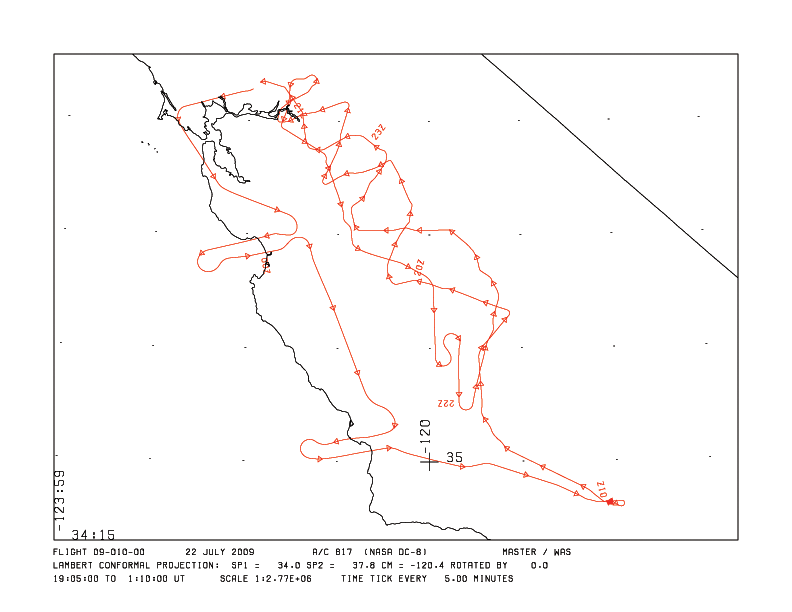
MASTER: HyspIRI Airborne Campaign, California and Nevada, Summer 2016 recent views
National Aeronautics and Space Administration —
This dataset includes Level 1B (L1B) and Level 2 (L2) data products from the MODIS/ASTER Airborne Simulator (MASTER) instrument. The data were collected as part of... -
Federal
BOREAS/SRC AMS Suite A Surface Meteorological and Radiation Data: 1996 recent views
National Aeronautics and Space Administration —
Contains the data collected in 1996 by the AMS suite A instrument set operated by SRC and provided to BORIS. -
Federal
BOREAS/SRC AMS Suite A Surface Meteorological and Radiation Data: 1994 recent views
National Aeronautics and Space Administration —
Contains the data collected in 1994 by the AMS suite A instrument set operated by SRC and provided to BORIS.

Official websites use .gov
A
.gov website belongs to an official government
organization in the United States.
Secure .gov websites use HTTPS
A
lock (
) or https:// means you’ve safely connected to
the .gov website. Share sensitive information only on official,
secure websites.